OpenStreetMap logo OpenStreetMap

Users' Diaries

Recent diary entries

An sve01 / svwd01 vector map

For some time I’ve been looking after a raster map style that’s designed to be a useful “England and Wales rural pedestrian” map, and also to showcase some of the richness of data that might not be obvious from basic “general” map styles such as the ones on OpenStreetMap.Org.

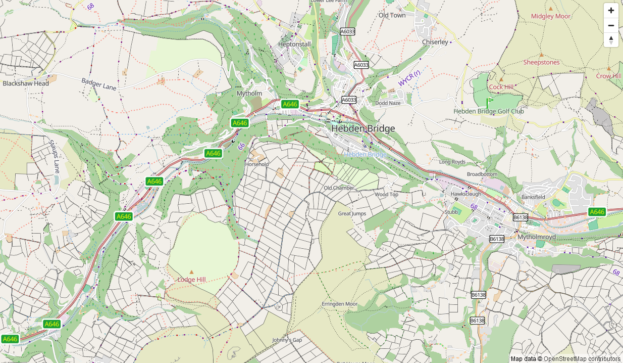
A goal for some time has been an offline version of that map style. At any useful level of detail that requires different technologies to be used, and the first parts of that - a vector map schema and a web map style - are now available (though not yet available offline).

The online version of that map is available here. It’ll take a couple of seconds to appear.

How vector maps work

See full entry

Location: Erringden, Calderdale, West Yorkshire, England, United Kingdom

Na základě dokončení opravy vedení linek MHD jsem mohl začít pracovat na webu, který má za cíl přehledně zobrazoval vedení autobusů, trolejbusů a tramvají ve městě Brně se všemi variantami konečných v aktuálním znění bez výluk kratších než 2 měsíce. Web je statický, založený pouze na HTML, JS a CSS. Projekt je na GitHub, kde rovněž hostuje v rámci GitHub Pages.

Webová aplikace https://mhd-brno.cz je veřejná, nicméně obsahuje funkce, které pomáhají v práci řidičům MHD ve službě na trasách, které běžně nejezdí a potřebují ověřit její vedení, zastávky a orientovat se na trase v souvislosti se svojí polohou, tedy v reálném čase.

Hlavní funkce webu

  • Zobrazení mapy (OSM a ČÚZK).
  • Načítání relací linek Public Transport, kde je jedním z operátorů DPMB pomocí Overpass API.
  • Zobrazení všech variant trsy s možným výběrem varianty, kdy se k ní vypíší i zastávky dle pořadí na trase.
  • Získání a udržování polohy uživatele (typicky řidiče MHD) ve středu obrazovky a natáčením mapy ve směru jízdy. Nejedná se o plnou navigaci, ale pro orientaci vedení linky slouží dobře.
  • Udržování rozsvíceného displaye při aktivní poloze uživatele.
  • Instalace do mobilu jako webová aplikace (PWA). Zde bohužel vlivem známé chyby na straně Apple v systému iOS neakceptuje požadavek na stále rozsvícenou obrazovku. Při otevření webu běžnou cestou v prohlížeči Safari však vše funguje bezchybně.

See full entry

Preface

I created this template to aid project co-ordination in tasking managers, and contributors seeking feeback. It has gone through several iterations; this is the one that I currently use. I think that there will likely be some alterations, because I see some potential impovements, though I haven’t yet received feedback regarding it from mappers.

Following interest in the template I use for validation comments from other validators, I am going to share the current version I use in this diary entry. Please, try it out and share your ideas, experiences, and results.

The template is formatted using Markdown.

Thank you to anthaas for the idea of publishing a diary entry about it.

My experience is in using the HOT TM so there may be some idiosyncratic parts which should be modified to be accurate/function within whichever TM is being used.

I have not yet seen what if any impact this has on 3rd pass validation.

Design Rationale

It was over two years ago now that I (in)validated my first tasks on the HOT tasking manager. I took a break from that until ~ 7 months ago when I started validating some more tasks here and there. Then ~ 4 months ago SColchester put me onto a good project for a beginer validator, and after that I was validating tasks at a significantly greater rate. It was also his comment on a previous diary entry of mine that insired a change in this temlpate.

After (in)validating a greater number of tasks via the HOT TM, I soon found that I was repeating myself quite a lot. For instance, linking to learning resources, events and thanking users for their contributions was very standard. I didn’t exactly fancy writing the same thing over and over, and I wanted to reach more contributors, so I decided to create something that’d make the process more efficient and idealy result in a higher quality of contributions.

See full entry

Posted by juminet on 9 November 2024 in French (Français). Last updated on 16 November 2024.

Mise à jour du taux de complétion des adresses dans OpenStreetMap. Cet article fait suite à une série d’autres articles ici en septembre 2022, en mai 2023, et en mai 2024, où je compare le nombre d’adresses par communes en Wallonie entre la source de référence des adresses (ICAR) et OSM.

Mais cette fois-ci, j’ai aussi mis à jour la source des adresses officielles (ICAR), ce qui fait que la progression dans la complétion des adresses semble reculer! J’ai aussi corrigé le calcul en omettant les adresses OSM dupliquées par un point dans un polygone (typiquement un noeud d’un commerce/horeca qui contient l’adresse et qui se trouve dans un batiment avec la même adresse -> certains adresses étaient comptés en double).

En Wallonie, 1,206,060 adresses sont répertoriés dans OSM, contre 1,829,093 dans ICAR (65.9 %). On était à 64.4 % en septembre 2022 et 67.1% en mai 2023 et 73.2% en mai 2024. La mise à jour de le source des adresses semble faire reculer la complétion, mais pourtant les adresses OSM progressent toujours et à un rythme régulier!

Attention, beaucoup d’adresses officielles sont maintenant définies AVANT la construction des immeubles, typiquement dans les nouveaux lotissements. Cela fait de facto qu’arriver à 100% pour certaines communes n’est pas vraiment pertinent. Dans la commune de Habay par exemple, on a un taux de complétion de 85% seulement alors que l’immense majorité des batiments construits sont dans OSM avec leur adresse: des dizaines voire centaines d’adresses non encore construites sont déjà dans ICAR.

Voici une carte choroplète, montrant, pour chaque commune, le degré de complétion des adresses dans OSM par rapport à ICAR. Les limites de provinces sont soulignées par un trait plus gras.

See full entry

Location: Au Pigeon, Marbehan, Rulles, Habay, Virton, Luxembourg, Wallonie, 6724, Belgique
Posted by dpschep on 9 November 2024 in English. Last updated on 25 January 2025.

In January, I introduced Overpass Ultra v2 and then in June I provided some updates. Today I’m excited to share that Overpass Ultra is now simply Ultra(v3) as it has evolved beyond simply being an Overpass client into a general purpose MapLibre GL JS IDE.

Since my last update, the following features have been implemented, culminating in the release & announcement of Ultra:

  • More extensive documentation
  • The concept of query providers
  • Auto-sorting of paint and layout layer styling directives
  • Fallback glyphs
  • Bundled icons as named sprite sheets
  • HTMLControl to add custom controls, including titles to a map

📘 Documentation

At the end of June, I announced overpass-ultra.us/docs on Mastodon. In addition to basic documentation about Ultra, it includes many Examples which are focused more on Ultra’s capabilities than the specifics of quering Overpass as there are already many resources for how to do that. It also includes a MapLibre Examples section which includes ports of many MapLibre GL JS Examples to help demonstrate Ultra’s capabilities as a MapLibre IDE rather than as an Overpass client.

⚙️ Query Providers

If you’ve kept a keen eye on the afforementioned docs, you’ll have noticed that you can specify the query provider with the type key in the YAML frontmatter

Ultra’s Overpass API support is now merely one of many query providers that are supported. Ultra now implements query providers for the following:

📄 JSON & XML GIS file formats

The geojson, kml, gpx, and tcx providers all work by simply specifying the contents of a document or the URL to a document as the query body.

For example, an in-line GeoJSON query doc (Load query in Ultra)

See full entry

Posted by Pieter Vander Vennet on 9 November 2024 in English. Last updated on 13 June 2025.

Hey all,

If you want to verify your OSM-account and get that nice badge, this is possible.

UPDATE: since june (or was it may?) 2025, the OSM website introduced “social links” in the user profile. You can link your mastodon account in there and save. (*)

Then, on your Mastodon-account, go to Preferences > Public Profile. Under ‘extra fields’, set ‘OpenStreetMap’ to the left and a link to your account to the right.

(*): Previously, one had to add a html-link with rel="me" attribute into the user profile.

Posted by Yoan Baptista on 9 November 2024 in Indonesian (Bahasa Indonesia).

Pengetahuan adalah bagian dari peradaban. Peradaban adalah hasil dari kemajuan. Kemajuan adalah proses dari peradaban. Pengetahuan-peradaban-kemajuan=sejarah.

Sejarah adalah hasil dari pengetahuan-peradaban-kemajuan. Sehingga sejarah adalah Wujud dari kehidupan.

Tak ada sejarah yg tak ada kehidupan. Begitu pula kehidupan yg tak ada sejarah.

🙏🏻 Swastika

Location: Tengkulawar, Manggarai, Nusa Tenggara Timur, Nusa Tenggara, Indonesia

Les données de population sont majoritairement obsolètes.

J’ai un script qui permet la mise à jour des communes (relation et admin_centre) depuis le fichier INSEE avec un changeset par département.

Fichier INSEE: https://www.insee.fr/fr/statistiques/8201904?sommaire=8202287

Discussion: https://forum.openstreetmap.fr/t/mise-a-jour-automatique-des-population-depuis-les-donnees-insee/7524/35

Commentaire du changeset : Update population https://wiki.openstreetmap.org/wiki/Tag:year=2021 https://wiki.openstreetmap.org/wiki/Tag:source=INSEE 2024 #updatePopulation #France puis Update population https://wiki.openstreetmap.org/wiki/Tag:year=2021 https://wiki.openstreetmap.org/wiki/Tag:source=INSEE 2024 https://wiki.openstreetmap.org/wiki/Tag:departement=<ref> #updatePopulation #France

Code source: https://framagit.org/Artefacts/osm-population-france-update

Calling all passionate mappers, open data enthusiasts, and geospatial innovators!

We’re thrilled to announce that the State of Map Kerala 2024 is just around the corner, and we’re extending the deadline for our Call for Proposals!

Do you have a story to tell? An OSM mapping project to showcase? Expertise in open data or geospatial technology to share? We want to hear from YOU! SotM Kerala Call for proposals extended

This is your chance to:
* Inspire the OSM Kerala community with your insights, experiences, and skills.
* Connect with fellow mappers and build valuable connections.
* Showcase your work on a platform dedicated to open mapping and open data.

We’re looking for proposals for:

  1. Lightning Talks (7 minutes): Short, impactful presentations to spark discussion.
  2. Talks (20 minutes): In-depth dives into specific topics related to OSM, open data, or geospatial innovation.
  3. Workshops (120 minutes): Interactive sessions that provide hands-on learning experiences.

See full entry

Location: Pokkode Diary Colony, Pookode, Vythiri, Wayanad, Kerala, 673576, India

OpenStreetMap; State of the Map Kerala 2024

The organizing committee meeting and Welcome Commitee formation will be held on 8/11/24 at 4 PM at the Veterinary University, Pookode, Wayanad. SotM Kerala - Formation of a Welcome Committee Following this, a basic OSM training session will be organized for students of the College of Veterinary and Animal Sciences and NSS volunteers.

Everyone is welcome to attend the meeting.

Location: Pokkode Diary Colony, Pookode, Vythiri, Wayanad, Kerala, 673576, India

It was a bright sunny afternoon in Ohio, but it was getting hard to tell from the smoke in the air.

Our Volunteer Fire Department was dispatched as mutual aid to fight a brush fire that had already burned dozens of acres. Once we got to the staging area and offloaded our brush unit side by side, I hopped in the shotgun/co-driver seat and we ventured into the woods to slowly find our way to the fire. Cell reception became practically non existent as the already mediocre network got bogged down by residents checking on each other. With sat imagery unable to load I thought OSMand and it’s offline data would be able to help us out.

We were making our way past a large pond that would prove to be a vital real world landmark for our vehicles moving to and from the fire. Even though land use was mapped I couldn’t see any useful terrain features. At one point in the past an OSM mapper simply marked the whole area as a big block of “Natural Wood” and moved on. I had to manually pin the landmarks in OSMand to give us bread crumbs to follow.

After a few hours and several hundred gallons of water being shuttled to the fire it was getting dark, but we could see the flames were no longer making progress. A county drone was now buzzing overhead and the operator confirmed that the fire was blocked by a swathe of wetlands. More fire units were stuck on the other side of it since it seemed like the fastest way to the fire from the opposite street, and they had to find their way around.

See full entry

Posted by SColchester on 7 November 2024 in English. Last updated on 12 November 2024.

Missing Maps turned ten years old in November and it may be running a full-blown internship in its tenth year.

Partially to celebrate this tenth birthday Missing Maps member organizations met for two full days in September in Nairobi, Kenya.

2024 MM Gathering
Vojtech Rehak (MSF) top left presenting on day one of the gathering, clockwise onwards around the table: Jorieke Vyncke (MSF), Benjamin ‘Benni’ Herfort (HeiGIT), Nash Naufal (MSF), Paul Knight (British Red Cross), Zacharia Muindi (Map Kibera), Rory Nealon (YouthMappers) and Sam Colchester (HOT) taking photo

What we talked about


A Short History of Missing Maps … the Last Ten Years

We reflected on the fact that on 5 November 2014, HOT, American Red Cross, British Red Cross and MSF launched the Missing Maps Project. Originally stating:

See full entry

Votação de Proposta para tag addr:milestone

Esta proposta é criar uma nova tag addr:milestone=* para se enquadrar nas subchaves disponíveis addr=*, para ser usada em um sistema de endereços (rural) muito comum encontrado em todo o mundo. O objetivo desta etiqueta é incluir especificamente os quilômetros (ou milhas ~ onde quer que seja usado) nos casos em que esses dados fazem parte de um endereço real, fornecendo assim uma “referência” visível para a distância necessária para viajar para chegar a um endereço específico, localização.

Esta etiqueta proposta também contribuiria para manter todos os números relacionados com o endereço claramente visíveis num sistema do “mundo real” que é actualmente utilizado em muitos países.

O Mapador Jorge da Comunidade LATAM Coloquei a proposta para a tag https://wiki.openstreetmap.org/wiki/Key:addr:milestone para votação, osm.wiki/Proposal:Addr:milestone peço que vote e ajude na aprovação dessa tag que será de grande importância para o mapeamento de km em rodovias brasileiras onde precisar ser mapeado o ponto da rodovia marcado como KM.

See full entry

Павильон Росси в Михайловском парке, Санкт-Петербург, 122 части, третье место в СПб. Это один из наших архитектурных шедевров, и представляет собой одновременно и пристань, и садовую беседку для романтических чаепитий.

Я его уже показывал, но теперь он загружен в OSM и отображается на F4 :

Павильон Росси на demo.f4map.com

See full entry