Posted by anti-caveman on 14 July 2024 in Ukrainian (Українська).
Last updated on 18 July 2025.
Контролювати вул Світла щоб не видалили old name ,osm.org/#map=19/50.74767897276036/25.33571601636439
Контролювати вул Світла щоб не видалили old name ,osm.org/#map=19/50.74767897276036/25.33571601636439
Ini adalah notes pertama untuk OSM
.
Tengo un plan reciente, que es mejorar tanto como pueda los datos del mapa de OpenStreetMap de mercado y sus alrededores en Penonomé. El problema actual es la falta de muchos POI, así que quiero añadir todos los POI que vea, preferiblemente con detalles como información de contacto y horarios de apertura. Del mismo modo, marcaré en OpenStreetMap los cruces peatonales, reductores de velocidad, y límites de velocidad que vea. El problema actual de OpenStreetMap es la falta de contribuidores, al menos en Penonomé, no hay muchos. Cada persona adicional suma una fuerza, así que ¡quiero mejorar tanto como pueda!
Recently, I have a plan, which is to improve the OpenStreetMap map data of the mercado and surrounding areas in Penonomé as much as I can. The current issue we face is the lack of many POIs, so I want to add all the POIs I see, preferably with detailed information such as contact details and opening hours. Similarly, I will also mark pedestrian crossings, speed bumps, and road speed limits that I observe on OpenStreetMap. The current issue with OpenStreetMap is the lack of contributors, at least in Penonomé, there aren’t many contributors. Every additional person adds more strength, so I want to improve as much as I can!
我最近有个计划,那就是要尽我所能的改进 Penonomé 的 mercado 及周边区域的 OpenStreetMap 地图数据,现在面临的问题就是缺失了很多 POI,所以我要把我看见的 POI 都加上,最好还能加上详细信息,例如联系方式、营业时间等信息,同样的,我也会在 OpenStreetMap 上标记我看到的人行横道、减速带、道路限速信息等,现在 OpenStreetMap 面临的问题就是贡献的人不多,至少在 Penonomé 没多少贡献者,多一个人就多一份力量,所以我要尽我所能的改进好!
Contáctame / contact me / 联系我: Telegram

Hello, Openstreetmap community! I’m Brazil Singh, Open Mapping Guru, and I’m excited to share the highlights from my recent training session at Jahangirnagar University. As an Open Mapping Guru under the Open Mapping Hub - Asia Pacific, this experience was both enlightening and thrilling, filled with dynamic discussions, insightful training sessions, and endless fun. Here’s a summary of our amazing day together!
The session began at 2 PM with a vibrant atmosphere. We were honored to have several distinguished guests who contributed immensely to the event:
Chief Guest: Dr. Sheikh Tawhidul Islam, Professor at the Institute of Remote Sensing and GIS, Jahangirnagar University
Special Guests:
    Md. Munir Mahmud, Assistant Professor at the Institute of Remote Sensing and GIS, Jahangirnagar University
    Sawan Shariar, Regional Ambassador at YouthMappers and President of OSM Bangladesh
OpenStreetMap Training:
Dear diary, today I made my account. I hope this can count for CAS :skull:
Yesterday was a hectic day and I missed a day of mapping. I will try to make it up.
Today I mapped Duhanas which is a big village in Berat with a population of around 1500.
“#100villagesin100days #day37”
I’ve been using StreetComplete for the past few days now. It’s great fun, but I often run into questions where I’m thinking “Well… I don’t know that any of these options are right.” (Or “If Regina wasn’t a uniquely hot mess, then maybe one of these answers would actually work!” I’m looking at you Albert street rail crossing.) The tagging and questionable-edits channels on the osm-world discord have been massive helps.
It isn’t until you start tagging out in the wild that you start coming up with weird questions that you wouldn’t have thought up otherwise. Like:
My journey into mapping began in 2012 when I was a college student. I started by mapping my village and later expanded to mapping numerous banks as part of my work in 2016-17. This initial exposure sparked my interest in community mapping.
In 2018, I began contributing to OpenStreetMap (OSM) alongside my volunteer contributions on Wikipedia and Wikidata. This involvement allowed me to bridge the gap between platforms by linking Wikidata entries with OSM and vice versa, enhancing the data quality and interconnectivity between these valuable resources.
Joining the Open Mapping Guru Fellowship has been a transformative experience. The fellowship provided me with access to various tools that have significantly enhanced my mapping activities. The tasks during the program helped me learn and expand my knowledge about mapping in OSM. These tasks ranged from mapping amenities using mobile applications like Every Door and remote mapping using JOSM and mapping and validating using the Tasking Manager.
Through this fellowship, I have not only improved my technical abilities but also deepened my commitment to the OSM community. The Open Mapping Guru Fellowship has been a significant part of my journey, and I’m excited about what lies ahead.
I am grateful to HOT and APHub team for this opportunity to be part of such a dynamic and collaborative environment.
As I continue my mapping journey, I look forward to applying the skills and insights gained from the fellowship to make a meaningful impact on the mapping and open data ecosystems.
PROSES ABSENSI
It just feels like yesterday that I started OpenStreetMap Calendar, but that’s maybe because the journey has been mostly smooth sailing. I started it sometime in early summer of 2019, made it more useful by the end of that year by adding calendar subscriptions and an API. In 2020, thanks to the Microgrant, I was able to focus a little bit more on it, so it got time zone support and a wiki integration, which then replaced the old wiki-based calendar in December 2020.
Since then I have teased a few features, but not that much has actually happened: There has been the odd improvement here and there, at some point I had to add minimal moderation tools so that spam can be removed without me having to shell into the database, but other than that OSMCAL lives its own life thanks to the users who use it.
Until today, more than 2800 events have been created:

There is an OSM event happening somewhere, almost every day:
WeeklyOSM informed us recently, that the videos of the recent SOTM FR are now available at https://peertube.openstreetmap.fr/c/sotm_fr_2024/videos.
There are english subtitles that seem to be good enough to get the gist of the video. Which is why I asked ChatGPT to take the RSS feed and create a translated summary so I can pick those that I find most interesting.
I thought this might be interesting for other, so here is the list…
Summary: This presentation by Guillaume Chauvet discusses the use of OpenStreetMap (OSM) data for mapping and improving train stations. It focuses on how OSM data is utilized within and around stations as part of the deployment of Metropolitan Regional Express Services (SERM) projects.
Link to Video: Watch Here
Summary: Located in the picturesque landscapes of Bourbonnais in Allier, L’Abel Destination used OpenStreetMap to enhance its territory. Within a year, the local tourism office staff trained in OSM, contributing detailed data on heritage sites, health services, shops, and local producers. This collaborative project highlights the process from funding to the final CartoGuide publication.
Link to Video: Watch Here
Summary: Nicolas Wurtz presents the story and future of “Carto Graou,” an online public railway map. Using polygons, lines, and points similar to LEGO pieces, the project integrates real-time data, opendata, and opensource elements. Initially aimed at enthusiasts, it has become indispensable and even useful for SNCF employees, with OpenStreetMap playing a crucial role in its success.
Link to Video: Watch Here
ค้นหา สิ่งที่ทุกคนอยากพบเจอในส่วนของการค้นหาข้อมูลเพิ่มเติมของที่เกี่ยวข้องมากที่สุดในแผ่นที่ค้าหา
Kinda ditched OSM last year when school ended. Gonna try to finish micro-mapping my neighborhood at the very least. That was my goal from the beginning and it remains so to this day. This time, though, I truly have absolutely nothing better to do.
After that, who knows? No promises… Probably gonna ditch it again when school starts up again x)
There are a couple I walk by every week, both pretty large.
I’ve tagged them https://wiki.openstreetmap.org/wiki/Tag:natural=beaver_dam ‘cos I found it in some discussion on the wiki somewhere.
Considering so much of Canada is shaped by beaver dams, I think they should get more respect.
(the location for this diary entry is near one of the beaver dams. It was not actually written while near it. If it had been, the beavers would have done their irritated tail-slapping dive to scare me away. It sounds like someone throwing a large rock into deep water.)
The openstreetmap project is the future of free data for resilience to the many problems of development and humanitarian response that we have in our communities. It gives access to a large database produced by enthusiasts, volunteers and people who believe that development or resilience in the face of the crises we face will require the support of such an initiative.
Someone once told me that to be immortal you have to give without expecting anything in return; support voluntary social actions as best you can,
support the initiative by making a donation of any amount, because at the end of the day it’s the gesture and the intention behind the gesture that counts.
http://supporting.openstreetmap.org/donate
or by having an impact on the management and direction of the Openstreetmap Foundation by becoming a member.
https://supporting.openstreetmap.org/#Membership-Categories
I’ve been a volunteer at openstreetmap since 2022 on 28 April and every day I try not only to help the openstreetmap project grow but also to participate in seeking and proposing solutions that could solve the problems we have in Africa, particularly in my country Cameroon, in nutrition, energy, quality education based on our cultures, water and empowering young people to face the challenges of our society. In short, the planning and development of our country
The last couple of days, I’ve been diving into a very sad chapter of Irish history - “industrial schools” which were children’s homes with less than favourable conditions for some of the children.
It stumbled into that rabbit hole, because a friend who went on a spin with me (I don’t drive myself, but I like being dependent on other people that way, because I always learn something from them that I wouldn’t have, if I drove myself) to look for holy wells had mentioned in passing a boys’ cemetery/ burial ground at St. Patrick’s Industrial School near Kilkenny. This school closed at some point after 1965 and the boys were transferred to St. Joseph’s Industrial School within Kilkenny city. St. Joseph’s had been only for girls until then.
I contacted our heritage officer at the local county council trying to find out whether they knew anything about this cemetery (I’m gonna stick with the OSM terminology from now on), but they had no record of it. It was also not marked on the official maps by Ordnance Survey Ireland (or the historical Ordnance Survey maps conducted by the UK government before Ireland’s independence).
Another friend who knew of the location offered to drive out with me and show me. So we went and I took photographs of all the grave markers (Category on Wikimedia), did a bit of mapillary and mapped the area as best I could (way/1298817559) 68 boys and one woman (as I found out later, a matron in her 80s) were recorded as having been buried there. I did a little more research on them which you can read here: https://en.wikipedia.org/wiki/List_of_names_recorded_at_St_Patrick%27s_Industrial_School_Cemetery,_Kilkenny
When we left, my “driver” mentioned that the nuns who ran the establishment (I hesitate to call it a school) also had a cemetery there, but we were pressed for time, so we didn’t visit it that day.
The next day, I cycled out and found the nuns’ cemetery which I also photographed and mapped as a cemetery.
Lo studio completo è disponibile su www.academia.edu.
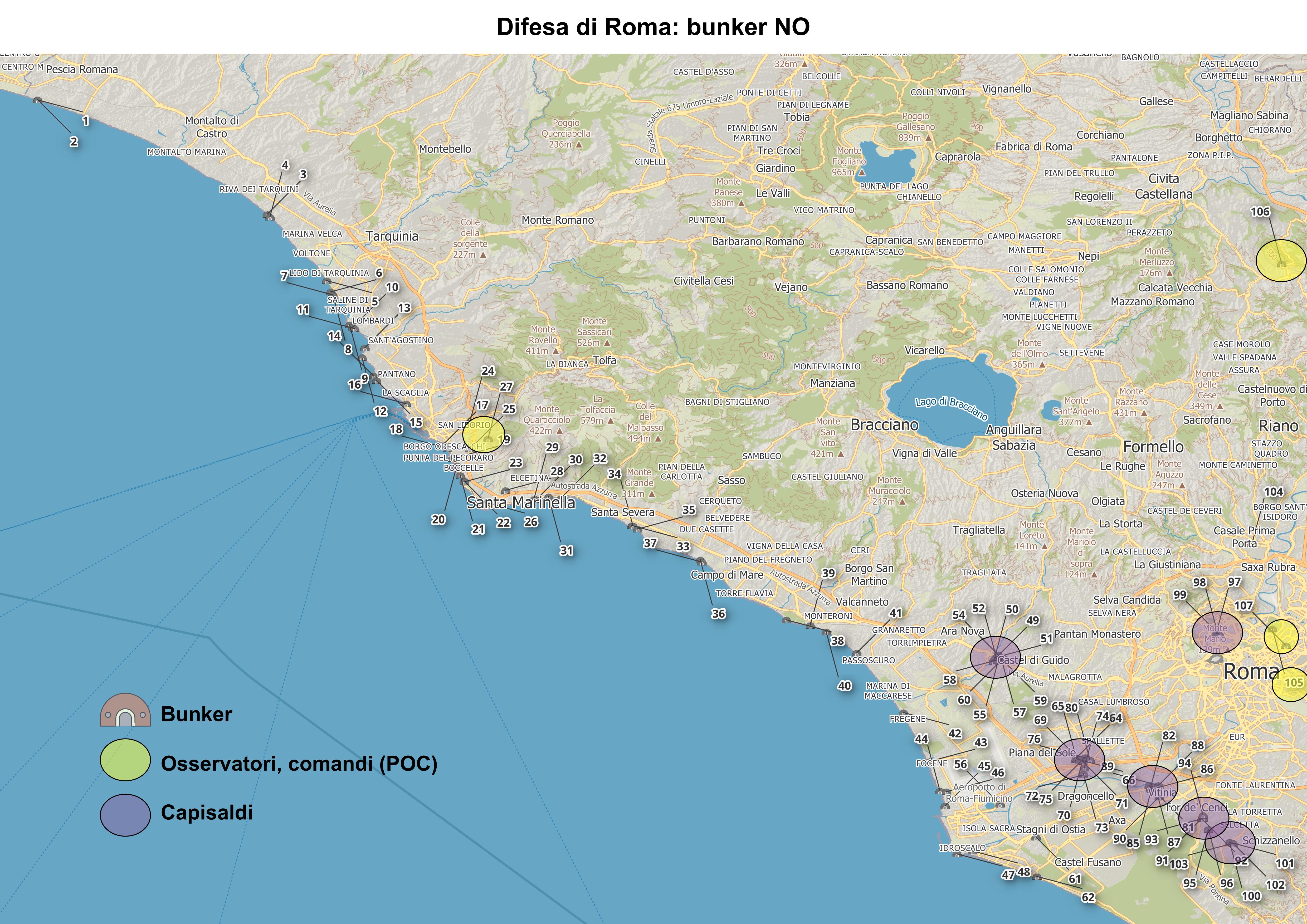
La mappatura è stata costruita mediante l’interpretazione delle immagini satellitari disponibili in JOSM e la documentazione consultabile su Internet riportata nella sitografia e bibliografia. Sono state individuate 108 postazioni militari costruite per la difesa di Roma e per contrastare possibili sbarchi a NO della capitale. Alcune decine di postazioni militari, come i capisaldi di Castel di Guido, Ponte Galeria, Trigoria e Vitinia o i bunker di Villa Torlonia, Ada e Soratte, erano già mappati in OSM altri, in particolare quelli posti lungo la costa tirrenica, sono nuovi.
Figura 1 Mappa dei caposaldi e bunker a NO di Roma.
 Visualizza a schermo intero
The rainy season, from April to June always reminds us that we need to be more than ready, but one would wonder why? We have our brothers and sisters who reside in northern and western provinces who are periodically exposed to the consequences of climate change and experience extreme weather and heavy rain every season.
We have resolved to not sit and wait again, so we have decided to take action, Not the heavy one to uplift or relocate every one in high risk but do what we do the best. mapping!
And our story here demonstrates that if we map together, we will overcome the disasters together. especially landslides upstream causing flooding downstream on a periodic frequency.


