
In case you might have not yet noticed, my current project on OSM is to cover the entire remainder of Vancouver Island with woodland data. I started with my home area of the Comox Valley and am radiating out from there in all directions, eventually finishing up with the area around Cape Scott. Every patch of forest I find in aerial imagery, no matter how expansive, even if the trees are small, will be added.
Users' Diaries
Recent diary entries
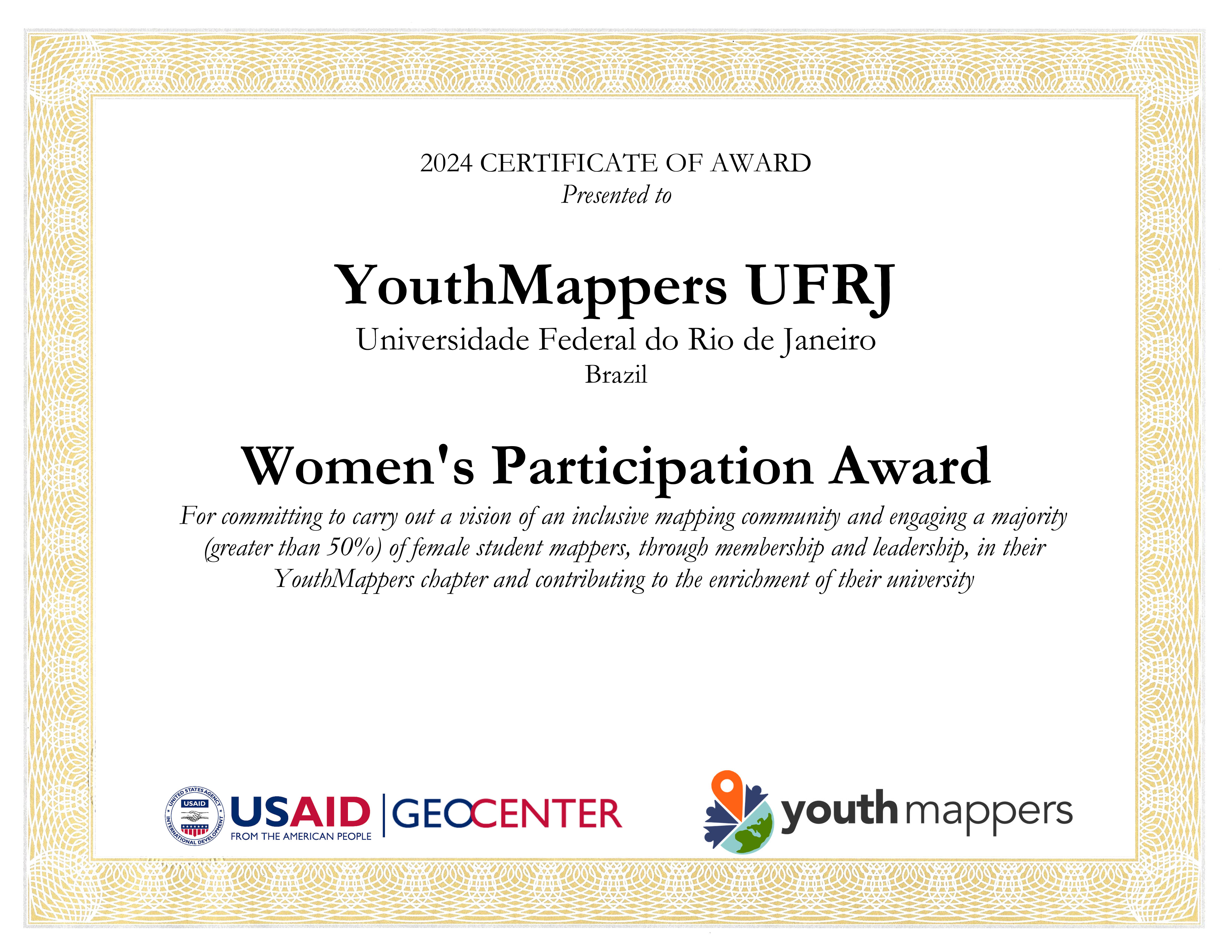
✔ YouthMappers UFRJ receives the Women’s Participation Award!
✔ YouthMappers UFRJ recebe o Women’s Participation Award!
✔ Our participation in the Open Data Day YouthMappers at UFBA 2024
✔ Nossa participação no Open Data Day 2024 do YouthMappers at UFBA
✔ Web map do mapeamento colaborativo para redução de riscos e desastes (RRD)
✔ Web map of colaborative mapping for the Disaster Risk Reduction (DRR)
✔ Mapear POI no OpenStreetMap e exibir dinamicamente com uMap
✔ Mapping POI in OpenStreetMap and displaying dynamically with uMap
✔ V Olimpíada Brasileira de Cartografia incluiu o OpenStreetMap como parte de sua etapa prática
✔ V Brazilian Cartographic Olympiad included OpenStreetMap as part of its practical stage
✔ Geocodificação com OpenStreetMap
✔ Mapeamento humanitário e OpenStreetMap
✔ Nossa participação no State of the Map Brasil 2023
✔ Atualização dos dados populacionais dos municípios brasileiros no OpenStreetMap
Posted by Raquel Dezidério Souto on 9 March 2024 in English.
Last updated on 30 April 2024.
✽✽ Women’s participation is recognized
The international project YouthMappers awarded the YouthMappers UFRJ Chapter (Rio de Janeiro, Brazil) for promoting women’s participation in its activities and organization, corresponding to more than 50% of its membership.
The YouthMappers UFRJ Chapter is an initiative of open collaborative mapping, that results of a partnership between the Virtual Institute for Sustainable Development - IVIDES.org and the Laboratory of Cartography - GeoCart-UFRJ, chaired by Dr. Raquel Dezidério Souto.
On this International Women’s Day, we dedicate this award to all girls and women, hoping that they can achieve their goals!
Posted by Raquel Dezidério Souto on 9 March 2024 in Brazilian Portuguese (Português do Brasil).
Last updated on 30 April 2024.
✽ ✽ Representatividade feminina é reconhecida
O projeto internacional YouthMappers premiou o capítulo YouthMappers UFRJ (Rio de Janeiro, Brasil), pela promoção da participação feminina em suas atividades e organização, correspondendo a mais de 50% de sua membresia.
O capítulo YouthMappers UFRJ é uma iniciativa de mapeamento colaborativo aberto, fruto da parceria entre o Instituto Virtual para o Desenvolvimento Sustentável - IVIDES.org e o Laboratório de Cartografia - GeoCart-UFRJ, sendo presidido pela Dra. Raquel Dezidério Souto.
Neste Dia Internacional das Mulheres, dedicamos este prêmio a todas as meninas e mulheres, que consigam sempre realizar os seus objetivos!
Our participation in the Open Data Day YouthMappers at UFBA 2024
Nossa participação no Open Data Day 2024 do YouthMappers at UFBA
Web map do mapeamento colaborativo para redução de riscos e desastes (RRD)
Web map of colaborative mapping for the Disaster Risk Reduction (DRR)
Mapear POI no OpenStreetMap e exibir dinamicamente com uMap
Mapping POI in OpenStreetMap and displaying dynamically with uMap
V Olimpíada Brasileira de Cartografia incluiu o OpenStreetMap como parte de sua etapa prática
V Brazilian Cartographic Olympiad included OpenStreetMap as part of its practical stage
Geocodificação com OpenStreetMap
Mapeamento humanitário e OpenStreetMap
Nossa participação no State of the Map Brasil 2023
Atualização dos dados populacionais dos municípios brasileiros no OpenStreetMap
Posted by Raquel Dezidério Souto on 8 March 2024 in English.
Last updated on 9 March 2024.
An event to strengthen alliances between mappers from Brazil and Africa
Between March 2nd and 5th, 2024, the event OPEN DATA DAY - Communities mapping communities: Brazil-Africa connection was held in Salvador (Bahia, Brazil), with the participation of Brazilians and Africans, who presented special keynotes and case studies on collaborative mapping, on the themes of sustainable development, gender equity, adequate housing, humanitarian mapping, disaster risk reduction and urban planning.
The YouthMappers at UFBA, producer of the event, also held mapathons, or mapping marathons, in the format of hybrid workshops, where participants mapped collaboratively on-line, using the editor iD for OpenStreetMap.
The YouthMappers UFRJ participated of the event, with the special keynote Collaborative mapping for disaster risk reduction - Case study: Municipality of Maricá (Rio de Janeiro, Brazil), given by its president, Dr. Raquel Dezidério Souto (IVIDES.org).
WATCH the RECORED VIDEO (in Portuguese and English), clicking here.
READ The PDF PRESENTATION FILE (in Portuguese and English), available here.
KNOW about this case study of collaborative mapping here.
Posted by Raquel Dezidério Souto on 8 March 2024 in Portuguese (Português).
Um evento para aproximar mapeadores do Brasil e da África
Entre os dias 02 e 05 de março de 2024, foi realizado em Salvador (Bahia, Brasil), o evento DIA DOS DADOS ABERTOS YouthMappers UFBA - Comunidades mapeando comunidades: Conexão Brasil-África, com a participação de brasileiros(as) e africanos(as), que apresentaram palestras e estudos de caso sobre mapeamento colaborativo, nas temáticas do desenvolvimento sustentável, equidade de gênero, direito à moradia digna, mapeamento humanitário, redução de riscos de desastres e planejamento urbano.
O capítulo YouthMappers at UFBA, produtor do evento, realizou ainda, as mapatonas, ou maratonas de mapeamento, no formato de oficinas híbridas, ministradas ao-vivo pela web, onde os(as) participantes mapearam colaborativamente e utilizando o editor iD para OpenStreetMap.
O YouthMappers UFRJ participou do evento, com a palestra Mapeamento colaborativo para redução de riscos e desastres - Estudo de caso: Município de Maricá (Rio de Janeiro, Brasil), ministrada pela sua presidenta, Dra. Raquel Dezidério Souto (IVIDES.org).
ASSISTA à PALESTRA GRAVADA (em português e inglês), clicando aqui.
LEIA o arquivo PDF da APRESENTAÇÃO (em português e inglês) está disponível neste link.
CONHEÇA mais sobre o MAPEAMENTO, clicando aqui.
Posted by radiotrefoil on 8 March 2024 in English.
Last updated on 4 April 2024.

Introduction
I am writing this tutorial because adding wireless connectivity to the cheapest hobbyist RTK module (Ardusimple simpleRTK2B) is very useful but not trivial for those inexperienced with electronics, and Ardusimple closed down their forums for… some reason. Hopefully this is something anyone can follow to make RTK more accessible to the general hobbyist mapper.
This entry is building on from my previous diary entry “Affordable, High Quality 360 Street Level Imagery using GoPro Fusion and Ardusimple”, I have now been using the rig for a couple years and it is holding up very nicely.
A quick summary is that I used the simpleRTK2B with my phone and GoPro Fusion 360 to make a very cheap and ultra portable street level imagery rig, for Mapillary or Kartaview. It can be used handheld or mounted to a car or bicycle.
The last survey I went on, whilst mostly fine, did bring up some issues regarding the reliability of the USB OTG data connection. This has always been a weak point of the rig in other ways because;
- the USB connection would drain my phone’s battery and make it difficult to charge the phone simultaneously whilst surveying, unless using wireless charger
- the phone always needed to be in close proximity to the simpleRTK2B
- too easy to accidentally disconnect
- The OTG adapter is wobbly in the type-c port
As my Android app of choice “SW Maps” permits a bluetooth connection for the NTRIP corrections, it was the obvious way to go.
Bluetooth module choice
Ardusimple sells the Bluetooth XBEE module for the simpleRTK2B for €34 which is quite expensive. I know you’re reading this Ardusimple! Third party Bluetooth XBEE modules are somewhat cheaper (around $20 AUD), however I had a generic bluetooth UART module laying around so I decided to just solder it in. Similar ones are quite cheap to buy new, for example the arduino HC-06 module goes for around $10 AUD.
Connecting it up

Added sidewalks south of Center Avenue between Hazelwood and Hiland, north of ORB/PA-65. Connected sidewalk to previous additions from Ben Avon.
I plan to extend coverage north of Center Avenue within Emsworth, and south of ORB/PA-65.
Added some parking lots here and there where most obvious, and cleaned up the area around Camp Horne Road & ORB intersection. This area could likely use some more work.
Realigned buildings here and there based on updated aerial photography. Might make another pass because there are quite a few that seem to be several meters out of alignment. I’ll have to check the original data these were derived from, but at least so far it seems that the PEMA imagery is the most accurate and precise available. I’ve cross-checked several notable points against the Allegheny County GIS viewer to confirm alignment to the best of my ability for now.
(All images via WikimediaCommons)
So, I went on a little outing with a friend to look at some historic/ folkloristic sites that I hadn’t been to before. One of them was an old monastic site where there is still a working church with a holy well (https://wiki.openstreetmap.org/wiki/Tag:place_of_worship=holy_well) and high cross (https://wiki.openstreetmap.org/wiki/Tag:historic=high_cross) nearby. When we went to the holy well/ high cross site, I was delighted to see that the site also had a rag tree which hadn’t been recorded on the government’s Historic Environment Viewer.
 Now, there could be several reasons for that which I won’t go into, but it reminded me that rag trees were something I had wanted to map, but of course, there was no tagging scheme.
I had mapped some previously using just https://wiki.openstreetmap.org/wiki/Tag:natural=tree with various other tags, but I thought I needed a tagging scheme that was applicable to other countries and cultures as well.
Posted by se_bras on 7 March 2024 in Spanish (Español).
¡Hola a todos! Quiero compartir con ustedes algunos insights y avances del proyecto en el que he estado colaborando, específicamente en la validación de datos. TASK
La calidad de los datos en proyectos de gestión de riesgos es fundamental para garantizar la fiabilidad y precisión de la información utilizada en la toma de decisiones. ¡Pero también es importante recordar que los errores son oportunidades de aprendizaje!
Estos son algunos de los mensajes que he enviado en el task a las personas con base a los errores de mapeo que he encontrado:
En primer lugar un mensaje de agradecimiento: ¡Gracias a todos por su contribución a este proyecto! ¡Sigamos trabajando juntos en el mapeo colaborativo!
Ahora si:
📝 He agregado construcciones faltantes: Tip: Puedes poner imágenes diferentes para detectar todas las construcciones, sin embargo, recuerda siempre dibujar sobre la capa solicitada.
📝 He modificado la etiqueta de una vía: Recuerda que las unclassified las empleamos para las vías que conectan centros poblados.
📝 He modificado la etiqueta de una vía: Recuerda que empleamos la etiqueta service para vías que conectan a un lugar en específico como casas, industrias, negocios o barrios con acceso privado.
📝 He modificado la etiqueta de una vía: Recuerda que la etiqueta residencial la empleamos para vías en las ciudades o centros poblados.
📝 He encontrado que algunas construcciones compartían nodos: Te recomiendo emplear en JOSM el plug-in Building y presionar la letra Ctrl en tu teclado para evitar que las construcciones se peguen.
📝 He encontrado que algunas construcciones eran muy pequeñas: Esto suele pasar cuando los techos tienen color diferente. Te recomiendo emplear otras imágenes como guía.
Velar por el aprendizaje de los nuevos mapeadores es velar también por la calidad del mapa. ¡Ay que seguir apoyando a los nuevos maperos para seguir mejorando juntos!

Today marks a milestone in the development of OpenStreetMap NextGen. After months of rigorous development, I conducted the 1st OpenStreetMap NextGen performance benchmark, a crucial step towards realizing the vision of a more robust, efficient, and user-friendly OpenStreetMap.
The focus of today’s benchmark was on evaluating static and unauthenticated requests. Since this core functionality is unlikely to change significantly during future development, it’s the perfect time to test it.
Future benchmarks will focus on timing authenticated requests as well as API 0.6.
What was measured
The benchmark analyzed request processing speed, excluding network and client latency. Both osm-ruby and osm-ng support the X-Runtime response header, which tracks how long it takes to process a request and generate a response.
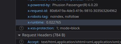
Here’s a general breakdown of a typical static request processing:

بانوير للدراجات الهوائية
2720 m
3520 m
3050 m
Peak Forest
Posted by spwoodcock on 5 March 2024 in English.
Last updated on 6 March 2024.

See pt1 of this series here.
See pt2 of this series here.
A Long Overdue Release
The goal with the Field Mapping Tasking Manager (FMTM) was to adopt an agile development style, making a new release around once per month.
3 months have passed since the last blog post and there was no FMTM release in between!
What gives??
Well, the team has been working extremely hard simplifying usage of FMTM and making it much more usable.
It’s been hard to find a good point to stabilise a release due to so many great and rapidly developed updates!
From this release onwards we plan to follow through with a new version increment every month. Look out for version 2024.4.0 next month.
Public Beta Now Live
- The main goal we have been working towards is releasing a public beta this month.
- The public beta for FMTM is now live on https://fmtm.hotosm.org
- The idea to to have the public test out it’s functionalities & definitely break a thing or two!
- With your valuable feedback we want to make FMTM the best it can possibly be 🙏
Started working on extending sidewalk mapping coverage into Emsworth Borough. I’m working much the same way as I did for Ben Avon, mapping sidewalks using a combination of aerial imagery, street-level photographs (Bing, PEMA, Esri, as well as my own), and in-person survey.
I was somewhat surprised to see that a footpath I have used numerous times going back many years was unmapped, so I added it (marked on the associated map).
I am trying how best to approach the area of Memorial Field (adjacent to Ohio River Boulevard / PA-65). The area currently marked shows as a football field, but the actual usage of the field is also a baseball diamond seasonally. In addition the area is shaped and sized differently than currently shown. Also, there are footpaths around it that are somewhat challenging to see on aerial imagery, so I suspect I will have to do some in-person GPS tracking to get better data. I am debating whether or not to map the pedestrian tunnel that passes beneath ORB/PA-65, as in the past I have been admonished that it is illegal to use. But it’s not physically blocked, nor are there posted signs indicating the access status. I just don’t want someone to wander through it and get into trouble, so maybe I’ll map it and tag it private or something to discourage public use until I can confirm.
I will probably bounce around between sidewalks and other features as I come across them.
kantor polsek manuhing