OpenStreetMap logo OpenStreetMap

Users' Diaries

Recent diary entries

Posted by SomeoneElse on 28 December 2023 in English. Last updated on 6 February 2024.

Norfolk coast near Cley

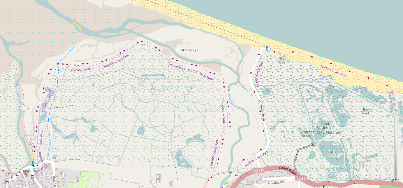
Tidal and non-tidal wetland

A major rewrite here takes into account tags such as natural, reef, wetland, surface and tidal before deciding how to show wetland areas. See the picture above, which is here, and here in OSM.

The beach between high and low tide can be clearly seen here (in OSM, here). There are blue dots in the sand rather than black. A deliberate decision was taken to show more detail for areas above low tide. See e.g. here between Wales and the Wirral (see here in OSM).

Island and islet names

See full entry

Location: Reask, Marhin ED, Kenmare Municipal District, County Kerry, Munster, V92 P681, Ireland
Posted by luziferius on 28 December 2023 in German (Deutsch). Last updated on 25 December 2024.

Ausgangslage

Unser Kenwood-Autoradio im Wohnmobil mit integrierter Navigation (Kenwood DNX450TR, Doppel-DIN-Format) hat das letzte Kartenupdate 2020 erhalten. Die Karten sind nun schon über 3 Jahre alt und zeigen häufig veraltete Geschwindigkeitsbegrenzungen, und es fehlen auch mal Umgehungsstraßen, Kreisverkehre, etc. Kurz, ein Update steht an.

Die Navigationsfunktion im Gerät ist von Garmin, welches als OEM-Partner von Kenwood die Navigationssoftware bereitstellt. Allerdings ist auf der Garmin-Webseite für OEM-Geräte das DNX450TR nicht mehr gelistet. Es gibt also anscheinend keine Kartenupdates vom Hersteller mehr.

Wir wollen auch während der Fahrt nicht vom Mobilfunknetz abhängig sein, entsprechend sind online-Navigationslösungen (Google Maps, etc) keine Alternative. Zusätzlich hat das Gerät keine gute Smartphone-Integration, daher funktioniert die Nutzung von Offline-Navigation auf dem Android-Telefon nicht zusammen mit dem DAB-Radio. Man kann zwar die Sprachausgabe des Telefons auf dem Autoradio ausgeben, hat dann aber kein Radio. Bei Ausgabe über den Telefonlautsprecher regelt natürlich das Radio nicht ab. Also auch keine zufriedenstellende Lösung.

Das teure Radio entsorgen (~ 1000€ Neupreis, wegen des LKW-Modus in der Navigationssoftware (TR = “truck” im Modellnamen)) und durch z.B. ein Gerät auf Android-Basis ersetzen ist ebenfalls nicht zufriedenstellend.

OpenStreetMap für das Kenwood/Garmin Navi?

Es gibt einige Anbieter von Garmin-kompatiblen Kartensätzen, die Liste aus dem OSM Wiki ist gut gefüllt: osm.wiki/OSM_Map_On_Garmin/Download

Aber

Die meisten der gelisteten Quellen sind optimiert für Hiking, MBT, Ski, Radfahren, Wandern, etc. Rendering ist optimiert für Garmin Handhelds mit Displays, die nur 16/64 Farben darstellen können, etc… Manche haben keine Indexsuche, entsprechend keine Adresseingabe, die aber für eine Autonavigation zwingend funktionieren muss. Die meisten angebotenen Karten haben schlicht einen eher inkompatiblen Hauptfokus.

See full entry

Posted by GovernorKeagan on 28 December 2023 in English.

Over the last few days I have been chipping away at validating tasks for the #osmIRL_buildings project.

I have now just finished validating all of Howth. There is still a good bit left in the rest of the county, some of it will definitely be quick due to some areas being rather rural.

Location: Howth Demesne, Ben Eadair A ED, Howth, Fingal, County Dublin, Leinster, Ireland

烦请各位不要动各个厂区内的密集路网图

还有一件事

炼化火坑炼化火坑炼化火坑炼化火坑炼化火坑炼化火坑炼化火坑炼化火坑炼化火坑炼化火坑炼化火坑炼化火坑炼化火坑炼化火坑炼化火坑炼化火坑炼化火坑炼化火坑炼化火坑炼化火坑炼化火坑炼化火坑炼化火坑炼化火坑炼化火坑炼化火坑炼化火坑炼化火坑炼化火坑炼化火坑炼化火坑炼化火坑炼化火坑炼化火坑炼化火坑炼化火坑炼化火坑炼化火坑炼化火坑炼化火坑炼化火坑炼化火坑炼化火坑炼化火坑炼化火坑炼化火坑炼化火坑炼化火坑炼化火坑炼化火坑炼化火坑炼化火坑炼化火坑炼化火坑炼化火坑炼化火坑炼化火坑炼化火坑炼化火坑炼化火坑炼化火坑炼化火坑炼化火坑炼化火坑炼化火坑炼化火坑炼化火坑炼化火坑炼化火坑炼化火坑炼化火坑炼化火坑炼化火坑炼化火坑炼化火坑炼化火坑炼化火坑炼化火坑炼化火坑炼化火坑炼化火坑炼化火坑炼化火坑炼化火坑炼化火坑炼化火坑炼化火坑炼化火坑炼化火坑炼化火坑炼化火坑炼化火坑炼化火坑炼化火坑炼化火坑炼化火坑炼化火坑炼化火坑炼化火坑炼化火坑炼化火坑炼化火坑炼化火坑炼化火坑炼化火坑炼化火坑炼化火坑炼化火坑炼化火坑炼化火坑炼化火坑炼化火坑炼化火坑炼化火坑炼化火坑炼化火坑炼化火坑炼化火坑炼化火坑炼化火坑炼化火坑炼化火坑炼化火坑炼化火坑炼化火坑炼化火坑炼化火坑炼化火坑炼化火坑炼化火坑炼化火坑炼化火坑炼化火坑炼化火坑炼化火坑炼化火坑炼化火坑炼化火坑炼化火坑炼化火坑炼化火坑炼化火坑炼化火坑炼化火坑炼化火坑炼化火坑炼化火坑炼化火坑炼化火坑炼化火坑炼化火坑炼化火坑炼化火坑炼化火坑炼化火坑炼化火坑炼化火坑炼化火坑炼化火坑炼化火坑炼化火坑炼化火坑炼化火坑炼化火坑炼化火坑炼化火坑炼化火坑炼化火坑炼化火坑炼化火坑炼化火坑炼化火坑炼化火坑炼化火坑炼化火坑炼化火坑炼化火坑炼化火坑炼化火坑炼化火坑炼化火坑炼化火坑炼化火坑炼化火坑

As I’ve noted elsewhere, I’m working on moving the JOSM plugin repository from svn to git.

I’ve managed to get something for most authors, but I am still missing attribution information for 47 authors with 95 commits between them.

If you have previously contributed to the JOSM plugin svn repository or the OSM svn repository (which used to include the JOSM plugin svn repository), please reach out to me via OSM messages or email ([email protected], [email protected], or [email protected]) if the attribution for your contributions is missing or wrong.

What I need from you:

  • The name you want your patches to be attributed to
  • The email you want your patches to be attributed to
    • As a reminder, this email will be publicly visible via git history. GitHub and GitLab both have noreply email addresses if privacy is a concern for you.
    • Grant Slater (firefishy) has the map used for migrating http://svn.openstreetmap.org/ to git. This will likely be used as a “last resort”; if the attribution from that conversion is OK, then no action is necessary.
  • Optionally, the timezone offset for your patches (UTC±offset)

Notes on the conversion:

  • patch by <foo> commits have been modified such that the originator (“<foo>”) is shown as the author, while the committer remains unchanged.
  • Doesn’t do much to reduce repo size – git lfs could be used for this prior to the final conversion
  • The dist directory for plugin releases has been excluded from the test repository due to size constraints
  • Does not split plugins into their own repositories. This can be done later.
  • plugin externals were converted to submodules; if a plugin had externals in it, those were not converted

WIP Repositories (please do not fork these; I may rebuild them at any time as I get new attribution information):

Posted by Danysan95 on 27 December 2023 in English.

Earlier this month during Wikidata Data Modeling Days Hannah Bast from University of Freiburg presented QLever, a SPARQL query engine with some really cool features (slides, recording). After a month of using it, in this post I’ll discuss how it’s relevant for the OSM community and my experience so far.

What’s SPARQL and why should we care?

SPARQL is a query language for RDF data, which can come from RDF-native knowledge graphs (there are thousands of them, public and private, the best known in the OSM community is Wikidata) or other sources (for example OSM) converted in RDF with some tool or middleware

SPARQL includes an optional extension for geospatial data, geoSPARQL. Query services implementing it allow to run all kinds of spatial queries with a naming similar to other query languages based on OGC standards (like SQL on PostGIS).

One notable feature of RDF and SPARQL is that they are made from the ground-up for interoperability between different data sources (“linked data”). SPARQL natively supports querying multiple RDF data sources in one single query through “federated queries”. This works by specifying inside the query to the first service the URL of the second service and its query, then specifying how the result should be merged or joined to the data from first service. If the second service is not blacklisted, the first service will handle autonomously the communication, merge the data and return directly the final output.

QLever

QLever and osm2rdf are two projects by the University of Freiburg; they were introduced respectively in 2017 and in 2021 but only recently started getting attention in the OSM world.

osm2rdf is a tool for converting OSM data into RDF. It transforms geometries from OSM’s node-way-relation format to Well Known Text (WKT) and can indirectly materialize containment and intersection relations between elements to improve spatial querying speed. It’s FOSS and extracts of the data it generates are available online.

See full entry

Posted by NorthCrab on 27 December 2023 in English. Last updated on 27 January 2024.

I have started an independent collection of OSM SLA statistics. Approximately once a month, I will publish my results with the aim of enhancing transparency regarding the reliability of OSM services. I use uptime-kuma to run monitoring. I also verify connectivity with non-OSM services (to prevent false positives). The current configuration includes checking the availability of openstreetmap-website and openstreetmap-cgimap (API). Tile layer availability is not currently included in the checks. The health-check resolution is set to 30 seconds, and the checks are executed from a single server in the Hetzner datacenter in Germany. For the endpoint to be marked unavailable, two consecutive checks must fail. This should be well-representative of an average user experience.

Summary

Total API downtime: 2 hours 34 minutes 13 seconds

API SLA: 99.643%

Total website downtime: 43 minutes 15 seconds

Website SLA: 99.900%

Note that some functionalities of the website require API to also be available.

Details

2023-11-30 10:07:24 - 2023-11-30 10:09:40

  • Total downtime: 2 minutes 16 seconds
  • 🚩 API unavailable

2023-11-30 10:16:16 - 2023-11-30 10:21:31

  • Total downtime: 5 minutes 15 seconds
  • 🚩 API unavailable

2023-11-30 21:34:44 - 2023-11-30 21:36:14

  • Total downtime: 1 minute 30 seconds
  • 🚩 API unavailable

2023-12-01 04:27:18 - 2023-12-01 04:29:00

  • Total downtime: 1 minute 42 seconds
  • 🚩 API unavailable

2023-12-01 17:26:20 - 2023-12-01 17:29:20

  • Total downtime: 3 minutes
  • 🚩 API unavailable

2023-12-01 17:45:06 - 2023-12-01 17:50:39

  • Total downtime: 5 minutes 33 seconds
  • 🚩 API unavailable

2023-12-01 17:50:39 - 2023-12-01 18:04:09

  • Total downtime: 13 minutes 30 seconds
  • 🚩 API unavailable
  • 🌐 Website unavailable

2023-12-01 18:04:09 - 2023-12-01 18:06:51

  • Total downtime: 2 minutes 42 seconds
  • 🚩 API unavailable

2023-12-01 18:09:38 - 2023-12-01 18:10:23

  • Total downtime: 45 seconds
  • 🚩 API unavailable

2023-12-01 18:12:25 - 2023-12-01 18:17:09

See full entry

Posted by b-unicycling on 26 December 2023 in English. Last updated on 29 December 2023.

The 30th of November saw the 4-year anniversary of the #osmIRL_buildings project, an ambitious project of the Irish OSM community to map all the buildings on the island. Co. Kilkenny had been the first project to be finished in the task manager in April of 2020, and I thought that it was high time to look at it again.

Since I live in that county, I had noticed missing buildings once in a while being on the road or mapping other things remotely. Relatively new (summer 2022) aerial imagery had been made available by Esri World which wasn’t as clear as Bing, but more recent.

So I decided to make a private task in the task manager and update the whole county by myself. I like to have side quests to make it more interesting, so I decided to also look for unrecorded archaeological sites. The summer of 2022 had been very dry, so crop marks would be more visible on the Esri World imagery. I wanted a private task, so nobody would map any of the tiles, and I might miss something. I usually map the bulk of the other tasks anyway, but I did not want to take any chances. This was going to be the most thorough search for crop marks and other clues to archaeological sites Kilkenny had ever seen. Or so I believe.

All in all, it took me 11 days or 75.5 hours (average time per task multiplied by tasks), but I had excluded Kilkenny city, because I usually have an eye on that all the time.

See full entry

Location: Coolnacrutta, Glashare, The Municipal District of Castlecomer, County Kilkenny, Leinster, Ireland
Posted by GovernorKeagan on 26 December 2023 in English.

I started mapping by updating shop details in my area and have now moved on to helping OSMirl in completing the various tasks to get all of Ireland on the map.

I have also started adding buildings to my home city of Port Elizabeth, South Africa. The majority of the suburb (that I’ve worked on) does not have any of the houses mapped.

Posted by Cristoffs on 26 December 2023 in English.

As always at the end of the year comes the time for summaries and plans for the coming year. Since a great deal of my activities is related to OSM I would like to share my plans with you for the the coming year of 2024. Despite not managing to achieve everything I planned (this year, the previous year), there was still a lot going on. So let’s start with a summary of the events of the year 2023:

  • I managed to conduct workshops and lectures promoting OSM in several new places, including the Wroclaw University of Technology and Adam Mickiewicz University in Poznan.
  • As every year, I promoted OSM’s go at GisDay held at the University of Lodz.
  • I conducted several Mapathons, supporting UN Mappers projects.
  • I established cooperation with colleagues from Croatia actively supporting them in updating data, and testing the use of building data from city resources and Overture Maps.
  • For the first time I took part in SotM, and I intend to participate in such events periodically.
  • The OpenAedMap project has received support from CloudFerro, which has allowed us to expand the functionality of the site, and secure the platform for the future.
  • The OpenAedMap.org project has gained support in the form of signing more patrons. The Center for E-Health, Warsaw University of Technology and the Medical University of Wroclaw have taken patronage of the project. I hope to expand the list of organizations supporting our initiative even further next year

Unfortunately, the list of plans that didn’t work out is much longer than I would like. This is what happens when there is not enough time or resources, and sometimes things just don’t go as intended.

See full entry

Posted by soumendrak on 25 December 2023 in English.

Day-20

Neis sites

  • Neis sites are down for a few days.
  • I started my first topic on Discourse regarding this issue. It looks like a single point of failure and actions need to be taken immediately as so many contributors use Neis’s sites and it is not even open source yet.
  • This website makes the editing more fun and a game-like experience.
  • Surprisingly, I have still been contributing to OSM without the country rankings or main area mapping slowly increasing.
  • The last time I checked before the site went down, I was the top 6th mapper in the last two months.

Every Door

  • I also learned about an app, Every Door, from my OSM Bengaluru Telegram group. We had a mapping party at Yelahanka this Saturday, but I could not join.
  • I localized the Every Door map in Odia language. Let’s see when it will be released to the App.
  • This App can help me maintain my 100-day streak.
Location: Okalipuram, Bengaluru Central City Corporation, Bengaluru, Bangalore North, Bengaluru Urban, Karnataka, 560021, India