خزين العجرمية
Users' Diaries
Recent diary entries
Yesterday I mapped a tiny area with lots of shops, bars, etc. This stretch of 43rd is so dense and diverse, it is really interesting. There are high-end establishments, but also a church and a food bank, convenience stores, a Mediterranean market. Next survey of the west portion of 43rd I think will go quicker as it becomes more suburban.
Some highlights:
-
I realized I need to add bulletin boards to my ‘look-for’ list - I found two of them in this little stretch, at a cafe and a record store.
-
Did not know there was a Mediterranean market so close to my neighborhood!
-
Found an interesting looking cafe I had never heard of (though it was closed at the time - will check out later)
-
Random excrement bag dispenser in a residential area on the way back - it’s silly but I love finding these, like a rare item in a video game :)

De retour après une semaine “de repos” lors de laquelle j’ai dû subir une opération pour me débarrasser d’une hernie récalcitrante (c’était ça la “raison personnelle” de la dernière fois). Maintenant j’ai droit à deux mois de repos lors desquelles je vais probablement passer du temps sur OSM et à faire des vidéos.
Le micromapping est un peu passé au second plan depuis ma rentrée de l’hôpital avec pas mal de changements du côté d’Ougrée après être passé quelques fois par là ces derniers temps, mais c’est toujours là malgré tout.
Quatre vidéos cette semaine, toutes sur OSM même vu que je suis assez limité dans mes déplacements pour le moment (et la météo craint même si j’en avais la possibilité) :
Améliorons Seraing (sur OpenStreetMap) - Épisode 19 (Ougrée et ses chemins vicinaux (encore)) - Version live de ce changeset où je modifie quelques rues et ajoute quelques sentiers sur Ougrée
Améliorons Seraing (sur OpenStreetMap) - Épisode 20 (L’update de la Bête) - Version live de ce changeset où j’ajoute tout un tas d’habitations manquantes sur Ougrée toujours
Améliorons Seraing (sur OpenStreetMap) - Épisode 21 (Les aubettes de la ligne 27) - Version live de ce changeset où… j’ajoute des abris de bus de la ligne 27 et corrige les arrêts de manière plus générale
Améliorons Seraing (sur OpenStreetMap) - Épisode 22 (Les bus du Beauséjour) - Version live (encore une) de ce changeset où je corrige les lignes de bus au Beauséjour
Et voilà pour cette semaine. Je ne sais pas si je tiendrais cette cadence au niveau des vidéos, mais les updates sur OSM devraient continuer à un rythme similaire.
A+
I am making my way along 43rd St in Kansas City, mapping most of the amenities and businesses I see along the way. About two weeks ago, I went from where 43rd breaks off at Gilham then west to Donutology, and today I worked through the stretch between Donutology and west to the nearby QuickTrip across from the Catholic church. I did not get very far because I walked into many of the businesses and chatted with folks, so as not to be suspiciously loitering outside :D
It was really fun to explore places I wouldn’t normally think to go to. I walked into Gigi’s Health Cafe (the proprietor saw me outside and came out to say hi, so I explained what I was doing and showed her the Every Door app where I was entering her business’s info), and also Paris Banh Mi, which looks like not much on the outside, but is really quite lovely inside.
I have lots of photos that I haven’t decided where to upload yet, but that will be its own project later probably. Along with various points of interest, I started taking photos of all the light poles and street cabinets that I notice which are covered with stickers and/or graffiti. Temporary signs fascinate me. Not sure if there’s a place for photos like those on OSM but I’m keeping them for something at any rate.
On my impression of OSM as a newbie: It looks like there are not a lot of active Kansas City mappers, and that anymore, most of the updates are done by businesses or by people who create / use automated tools, and the most active people are the ones getting deeply into the technical side. A lot of the diary entries I see are about conferences and full of dense technical and/or organizational jargon. Lots of businesses and nonprofits seem to be involved.
Posted by Zkir on 22 December 2023 in Russian (Русский).
Last updated on 23 December 2023.

Продолжение. Предыдущие части тут и тут.
Генерализация в масштабах планеты прошла (ну или почти прошла), и мы наконец увидим, как на самом деле отрисован OpenStreetMap.
Итак, отображаются natural=* и landuse=* :
 Если кликнуть по картинке и выбрать из меню “открыть картинку в новой вкладке”, можно рассмотреть ее в большем разрешении.
Если совсем коротко – Европа (что бы под этим словом не понималось) отрисована более-менее прилично, остальной мир – какие-то лоскуты. Евразийцев не завезли, степи и тундру рисовать никто не хочет. С американскими flyby states не лучше :)

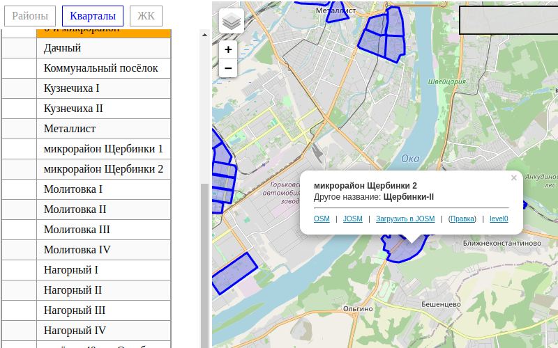
На одной карте удобно проверить правильно ли город разбивается на районы (place=suburb), небольшие кварталы (quarter), а также жилищные комплексы (neighbourhood)
I created my OSM at the beginning of 2023, on December 21, 2023 I created/updated my first map. I guess now this is for the long run.
-

Day 16
I joined OSM back in 2018. Then, there was a movement to use alternatives to Google products. For Google Maps, I found OSM.
Recently, in 2023, I finally started contributing to OSM seriously and continuously. Within around 50 days of contributions, I have already become a member of the OSM foundation and one of the top 10 mappers in India.
I am primarily focusing on:
- Adding buildings in Bhubaneswar, my birthplace area and
- Adding roads in Malkangiri, Odisha.
Today is Day 16 of my 100 days of OSM challenge. Let’s see where I will reach at the end of 100 days.
I have corrected alignments of buildings, shore line, roads for the area from Cherry Hill (NW) to Beaulieu (NE) down to Egmont (SE) and to the airport in the SW.
I’ve added some buildings, deleted others. Made corrections to some and added a few swimming pools. Put in a few roads, tracks, driveways and service roads. Most recently a load of solar panels at the energy company along with associated infrastructure. Fixing the St John’s River as best I could was fun. Not my first or longest and there is likely more to go.
I have reached my first goal: To make a baseline realignment for the SW of Grenada. I might give myself a little break and continue up the west coast to finish St George as the South coast it pretty congested and it will be nice to fix the whole district.

Mapa
This diary is about programming, as my diaries usually are. This diary is about the code, particularly about backend codebase of the HOT Tasking Manager (TM). TL;DR of this diary is: HOT TM code is unmaintainable mess and that will not change. HOT TM developers inherited something they can do nothing about. Please, prove me wrong if you can and end up my frustration.
I will try to find out why Error when trying to split tasks happens, so deep breath and dive.
I suspect backend, so I will omit the note that it could be replicated on chrome browser only. And I will start directly at TasksActionsSplitAPI of backend/api/tasts/actions.py file, because that looks reasonable.
In the first try block I need to find out what is that SplitTaskDTO. I always forgot what “DTO” means. The import line helps and looking into backend/models/dtos/grid_dto.py says it is “DTO used to split a task”. Thanks. But the code looks like the data structure so I merely remember the purpose – just data or alike.
Only the second try left, so let’s see. The comment on the first line says it checks the project exists. I am just curious how it’s implemented, so see backend/services/project_service.py to find out exists method. Side note – I completely misunderstand classes with static methods only. Oh, exists is just Project.exists. How is that implemented? Just curious… See backend/models/postgis/project.py to see that exists is… it looks like a database query. I don’t SQLAlchemy, but note the first database request. I will number them, this one being #1.
We are back at the second try. It looks the main work is done in split_task of backend/services/grid/split_service.py, so see that (static again) method. Well, heh, not funny anymore. But I am not going to give up easily this time. So split_task now.
Posted by mappinglander on 20 December 2023 in Turkish (Türkçe).
Last updated on 27 December 2023.
Geçtiğimiz günlerde Telegram grubunda bununla ilgili mesajlar atılmış, üzerine tartışılmıştı. Bunun üzerine ben de tüm noktaları özetlemek istedim. Şöyle ki;
-
OSMF kullanım şartlarında belirtildiği gibi bu konuda OSMF haklı olarak herhangi bir sorumluluk üstlenmiyor, herhangi bir garanti vermiyor. Sonuçta gönüllü haritacılar olarak yerel yasalara uymak zorundayız, bu bir.
- İkincisi ülkede halihazırda belli bir ölçekten daha küçük ölçekte harita yapmanın yasak olmasını veya herhangi bir haritalama faaliyeti için yüksek miktarda para ödenmesini, bu sayede Basarsoft’un tekelini geçtim; bunun dışında Askeri Yasak ve Güvenlik Bölgeleri Kanunu’nda oldukça geniş yasaklamalar da var askeri bölgelerle ilgili .
-
Üçe gelirsek, şu anda devlet/belediye kaynaklarından haritaya aktarılan çok fazla veri var. Bu verilerin çoğu telif haklı/ticari kullanıma izin vermiyor/lisansı açık kaynak lisansı olsa da OSM ile uyumsuz. Dolayısıyla yasal olarak gri bölgeler oluşuyor, belki biraz da bu tarz durumlarla ilgili çok fazla dava, mevzuat vs. olmadığı için (sonuçta kim Türkiye’de Creative Commons lisansı kullanıp da yanlış kullanan birini mahkemeye verir?). Bu kurumlar “Bak, ama kullanma” politikası güttüğü sürece de bu tarz işleri tehlikeli görüyorum.
- Dört: İkinci maddeden dolayı yerel bir OpenStreetMap organizasyonu/yerel derneği kurulamıyor, allahtan Yer Çizenler bu açığı bir nebze dolduruyor.
Dolayısıyla, birçok devlet kurumuna ve hatta geçtiğimiz seneki Maraş depremlerinde arama-kurtarma takımlarına OpenStreetMap oldukça yardımcı olmuş olsa da, ben de OpenStreetMap’te haritalama yapmayı sevsem de bunun gibi durumlardan dolayı daha az katkı sağlamayı düşünüyorum. Daha önceden de dikkat ediyordum ancak bu saatten sonra da başıma bela almamak için askeri bölgeleri haritalamamayı tercih edeceğim gibi duruyor.

พิมพ์นิยม
“The beauty of a tech journey lies in the shared struggles 🧩”

The quote above is a reminder that success is not a solitary path but a collective triumph over challenges. Everybody struggles 🤷🏽♂️. Tech’s greatest minds that we know today didn’t escape the struggle; they transformed it into the foundation of their success story. How about that?
The journey to breaking into the ever-evolving landscape of the tech industry can be challenging and daunting. From the overwhelming available knowledge to the diverse backgrounds that contribute to the beauty of the industry. You may want to grab a cup of coffee if you can, let’s quickly delve into the shared experiences that unites aspiring open source enthusiasts worldwide :)
The Struggle is Real
Posted by Zkir on 19 December 2023 in Russian (Русский).
Last updated on 21 December 2023.
Запустил импорт планеты в postgis, чтобы посмотреть покрытия для всех стран, но osm2pgsql за сутки планету не переварил. Эх, osm2pgsql такая большая заноза :(

Причем даже не сказать, что комп нагружен.
Posted by Vinber on 19 December 2023 in French (Français).
À l’occasion de la publication de “Se former à OpenStreetMap” sur le site de l’association OpenStreetMap France https://www.openstreetmap.fr/se-former-a-openstreetmap/, quelques retours sur la génèse de ces contenus pédagogiques.
Paru au bulletin officiel de l’éducation nationale, de la jeunesse et des sports, le bulletin officiel spécial n°1 du 22 janvier 2019 fixe le programme d’enseignement de Sciences Numériques et Technologie (SNT) de la classe de seconde générale et technologique.
Dans la thématique Localisation, cartographie et mobilité du programme en annexe, il est fait mention de contenus dans lesquels on trouve la capacité attendue Contribuer à OpenStreetMap de façon collaborative (page 15 de l’annexe ci-dessus).
Février 2019, la découverte pour OpenStreetMap-France
Lors du conseil d’administration des 2 et 3 février 2019, l’association OpenStreetMap France a appris par l’intermédiaires d’adhérents (contributeurs et enseignants) l’existence d’une nouvelle capacité en classe de seconde Contribuer de manière collaborative à OpenStreetMap. Déja évoquée sur le forum en décembre 2018 (https://forum.openstreetmap.fr/t/osm-et-enseignement-snt-en-lycee/2988), la question de la formation des enseignants y est abordée et des pistes d’activités pédagogiques également. Le point sera à l’ordre du jour du conseil d’administration en présentiel suivant (osm.wiki/France/OSM-FR/CA_2019-02-03#Ordre_du_jour_du_CA_physique_2-3_f%C3%A9vrier) sans beaucoup de suites. Aucun contact n’a été pris avec l’association OpenStreetMap France par le Ministère de l’Éducation Nationale.
De “mauvaises pratiques”
It’s wonderful to discover such beautiful and accurate mapping.
I checked my location in the Open Street Map and saw how accurate the buildings were mapped in the vicinity where I live in the province. It gave an accurate sizing of our location, which I found great.

🎊🎉 Rumo aos 30…..