OpenStreetMap logo OpenStreetMap

Users' Diaries

Recent diary entries

Posted by b-unicycling on 27 January 2023 in English. Last updated on 16 February 2023.

As usual, I can’t quite remember how it started, but this week, I was trying to find a list of all the National Monuments of Ireland. The National Monuments Service publishes lists by county which only contain the ones under state care. These lists have made their way to Wikipedia which is a great start. They have their numbers recorded there which I have transferred to OSM under ref:IE:nm for the counties of Kilkenny, Laois and Offaly so far. (the key is recorded on the wiki, of course.)

I have sent an email to the National Monuments Service asking for a list, but so far, no reply. I probably have a reputation there by now…

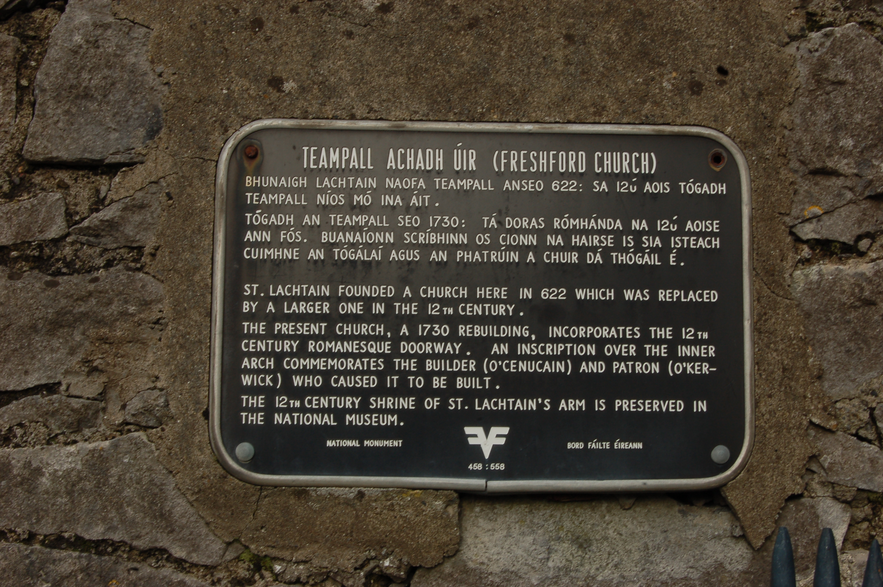
However, I noticed while visiting and taking some pictures of Freshford Church that it has a black plaque (the type of which I had seen before, but never read in much detail) which stated that it was a National Monument.

plaque

See full entry

I decided to continue trying to use JOSM for this area. I added details around the Narraguinnep Fort Historical Site, which was not simple. To add a point, I sit there in add mode and only click once so it doesn’t become a line? Hopefully that is so because that’s what I did. Then tracking down appropriate tags ended up meaning doing the same thing in iD, so not exactly a good use of time.

I continued on to details of the road around the Benchmark lookout. The track type changes halfway along. It’s nearly the boundary of the USGS map quads, so easy to miss, but they actually marked it. The road stops being improved dirt and becomes high clearance right in the middle. I did manage to figure out from JOSM how to mark that. In fact, now things are getting marked with tracktype. Smoothness was always presented, but maybe not as clear.

I decided to continue on with roads. The Forest Service marks various around the area as primary (trapezoid with an extra line markers on the map, maintained to passenger car standards) and secondary (horizontal numbers in a rectangle, should be to passenger car standards) and as 4x4 (vertical numbers in a rectangle, get the truck or even ATV). So how should one apply them? And why are they all marked as county roads, sometimes with segments with alternating numbers? None of it makes sense. I added some and lengthened some and adjusted some as I could see so their routes are all matching reality a bit better.

See full entry

Location: Dolores County, Colorado, United States

O cruceiro do Tabolado

O cruceiro do Tabolado, ou de Refexón, é o único que está nun cruce de camiños. Varal octogonal, sen inscripcións, un pedestal, sen imaxes. No cruce Louredo-Refexón (cara Remuíño, Arnoia)-Tabolado (Louredo, en liña cos barrios dos Veciños e O Pazo). O seu autor foi don Juan Míguez Domínguez. Do mesmo estilo que o da Alfarrapa e A Torre.

Confluencia de camiños

Postos ante o cruceiro (https://cutt.ly/Rb9UofQ), o camiño que sobe cara o pobo e barrio de Louredo (https://cutt.ly/2b9UYVi) queda ás costas (https://cutt.ly/Vb9UJHU), mentres que o do Tabolado (https://cutt.ly/Eb9UFHp) ábrese á man esquerda. Polo primeiro chegas ó peto de ánimas (https://cutt.ly/Rb9U8NJ) e tamén ós restos da escola pía (https://cutt.ly/Yb9Iw9Z). Polo segundo, ás viñas do Pireiro (https://cutt.ly/Bb9UQ6f), Tras do lagar e A Ladeira, ademais da escola do Tabolado (https://cutt.ly/Cb9IQS6), hoxe centro social. Hai un terceiro camiño, o da dereita, Refexón (nos mapas, Refoxón), que baixa cara Remuíño (https://cutt.ly/ob9IRwM) e que empata ca estrada cara Zaparín. Inda que se percorre en coche, hai un camiño que é o vello, quizás hoxe de monte e non practicable (https://cutt.ly/Bb9IUb7), polo que pasaron moitos louredeses no seu camiño ós muíños (https://cutt.ly/Rb9IFTL) do Inquiau (https://cutt.ly/ZYZMwXA).

O nome de cruceiro

Cruceiro do Tabolado, nun cruce de camiños. Moitos din que o cruceiro colócase en lugares así, pero non éa única opción á hora de entender de onde vén a palabra “cruceiro”. Tamén se fala de que poden ser construción en pedra que recordar a cruz procesional. E hainos que macan os límites de poboación (cruz de término).

See full entry

Location: Casa Grande da Canliña, Louredo, Cortegada, O Ribeiro, Ourense, Galicia, 32200, España

This is really just down the road from the last bit. I decided to finally try out JOSM for editing. Everyone’s doing it? It was initially harder to do the simple things. Frustratingly, it wouldn’t let me start a new line rather than adding to an old one as I started adding the trail at the end of the stub of road at the Rio Lado trailhead. This trail was supposed to be a circle on the end of about 2 miles of trail, but I found about 2 miles of trail and, unrelated to the location of the circle, some other random trails. There were even equestrians on one of them. Back to the mapping, I found that joining these various lines was difficult and I even managed to upload one without any tags at all. I went back and fixed things with iD, which isn’t appropriate. It does say that there’s a steep learning curve.

Then I moved on to the Calico National Recreation Trail. This is a motorcycle trail, but it actually does see plenty of hikers and mountain bikers, too. I was aiming at a bunch of peak bagging along its spine, but apparently was too rusty in my packing of my overnight backpack. I tagged Elliot Peak and returned. Then I took a different route up to the mountain spine to tag a few more peaks in an overnight. Sockrider first and the namesake Calico last.

See full entry

Location: Dolores County, Colorado, United States
Posted by SomeoneElse on 25 January 2023 in English. Last updated on 30 March 2023.

This isn’t directly related to OSM, but many times in “software” or “development” OSM channels someone has asked “how do I do X … on Windows 10?”.

The reason that’s often a question is that, for historical reasons, much of the OSM software used to do things has been developed on Linux. That’s great for people working on Linux themselves, and the Apple Macintosh users can normally jury-rig something to run that software too.

Windows users can do the same too, by installing “Windows Subsystem for Linux”. Within Windows, search for “Windows Features”:

In Windows Features, tick the box for WSL and click OK:

See full entry

(Un cuento de san Xoán de Louredo, Cortegada, Ourense)

El cruceiro de O Tabolado, también llamado de Refexón, es uno de los puntos de interés histórico del pueblo de Louredo. En una nota posterior me ocuparé de algunos datos, aquí os comparto un cuento relacionado con él, un fragmento de la tradición oral de los vecinos.

Allí, en el cruceiro de O Tabolado, se encontró un vecino con el demonio y este le recomendó un acto de fe… de fe cristiana.

Ya lo contaban los padres de mis padres, señalando, incluso, el lugar donde esta historia sucedió. En los tiempos en que los louredeses bajaban a Remuíñoa moler el grano del maíz, sucedió que un hombre, cargado con su saco, se encontró a otro, con un pequeño fuego que lo calentaba. Eran tiempos en los que se cargaba con el fruto de la tierra y el trabajo de los labradores, llevándolo desde las casas hasta los molinos de la zona del Inquiau, al paso del río Arnoia por el ayuntamiento del mismo nombre. El camino, en descenso, era una posible vía romana, y había sido recorrido por el padre Sarmiento en el s. XVIII.

Le llamamos Refexón (Refoxón en los mapas) y comienza en un cruce de senderos, donde un sencillo crucero bendice a cuantos le dedican una callada oración. El caso es que el vecino de Louredo iba con el saco a la espalda y pasó ante el cruceiro y el hombre de la lumbre como quien pasa delante de un gato. Unos pasos más allá escucha que el hombre le dice: oye, ya que no me saludas, por lo menos saluda a este que tengo al lado (refiriéndose al cruceiro).

No cuenta la historia si el hombre siguió tal como había entrado, pero sí que, una vez regresado de moler, buscó los restos del fuego que calentaba a aquel misterioso hombre… Y no los encontró. Por lo visto era el demonio que, bajo forma humana, merodeaba el pueblo aquella noche. Descansando del camino y buscando calor ante el relente de la noche, había aprovechado para lanzarle al despreocupado vecino un pío recordatorio.

See full entry

Location: Casa Grande da Canliña, Louredo, Cortegada, Ribeiro, Orense, Galicia, 32200, España

Querying elements from osm and doing practical things with them is really a useful and fun way of code “hacking” for me. In this case, I wanted to show farmers markets with a reactive map like leaflet like I’ve done before in my journal entries. In this case, I wanted to make it easy to browse the times, seasons, and contact info for farmers markets in the Anchorage, Alaska area. I think with some refinement this map could be useful to sellers and buyers to determine which farmers markets they can fit into their schedules.

See full entry

Location: Campbell, Anchorage, Alaska, 99518, United States

GIS data for listed buildings, scheduled monuments (e.g. interesting tumuli) and more can be downloaded from https://historicengland.org.uk/listing/the-list/open-data-hub/, and here are some observations based on my experiments with geoJSON and shapefiles.

The data is under the Open Government Licence so OK for editing OSM.

The download can be kept to a manageable size by enabling “Filter as map moves” in the filter menu (funnel symbol) and then “Toggle filters” when selecting the download.

Vespucci can display a geoJSON layer, show object attributes, and even create preliminary OSM objects from them. But it didn’t work here. I discovered that the downloaded geoJSON uses EPSG:3857 (projected coordinates) whereas the geoJSON standard is EPSG:4326 (latitude and longitude).

An easy way to do the conversion was to go to https://mapshaper.org, “upload” the file (actually it’s processed on the client side), open the console and enter:

-proj from=EPSG:3857 crs=EPSG:4326

and then export.

The resulting geoJSON works well in Vespucci. You can either “Add GeoJSON layer” from the layer menu, or select it in a file manager and open with Vespucci. I could do the whole process above on a modest android tablet.

OSM tags worth thinking about include:

  • heritage = 2
  • heritage:operator = Historic England
  • ref:GB:nhle =
  • listed_status =
  • wikidata =

Note that I’m not suggesting adding anything to the map that can’t be located with a ground survey, and certainly not blindly copying polygons (aside from considerations of verifiable ground truth, these may include a protective buffer around the feature).

See full entry

Posted by Tomas_J on 24 January 2023 in Slovak (Slovenčina). Last updated on 1 July 2025.

Text for visualy impaired: https://sa.tt.com.pl/osmtext/

Missing power lines in Slovakia

https://zabop.github.io/SVKgrid/ https://groups.google.com/g/osm_sk/c/J1IKRplN48o

Wikidata and OSM link: https://wiki.openstreetmap.orgdata.link

Google groups waterways cleanup https://groups.google.com/g/osm_sk/c/vpc9AlUEbD4

Google groups osm addresses https://groups.google.com/g/osm_sk/c/jNbKYEEfKyo

To create river geometry automatically in freeman SK/Vytvorenie návrhu koryta rieky v freemat sk: Create polygon and name it Cry me a river

Category:Slovakian tagging guidelines: osm.wiki/Category:Slovakian_tagging_guidelines

Slovak railways: osm.wiki/Slovakia_railways

Cislovanie trati podla tratovych usekov ZSR: http://www.zsr.sk/files/dopravcovia/zeleznicna-infrastruktura/podmienky-pouzivania-zel-infrastruktury/podmienky-pouzivania-zel-siete-2022/priloha2_3_a-zoznamtrati.pdf

Temporary closure of a highway (till half a year): access:conditional=no @ (2023 Jan 29-2023 Apr 16) motor_vehicle:conditional=no @ (2018 May 22-2018 Oct 7)

Sources/Zdroje: source=Ortofotomozaika SR DMR5: hillshade BW SR source=ZBGIS ❯ Ručne prekreslená budova podľa rastrovej katastrálnej mapy source=ÚGKK SR AKO ❯ Skopírovaná budova z vektorových dát katastrálnej mapy (aktuálne najpresnejšie)

Run forest run - diskusia a návod https://groups.google.com/g/osm_sk/c/YrlB8Q2hg24

AKO budovy

https://groups.google.com/u/1/g/osm_sk/c/oMjY5c0ZBAs/m/suTroDodAQAJ

…postup je taky ze stiahnes uzemie ktore potrebujes z https://ako.vugk.sk/ a potom cez nastroj od Margusa prekonvertujes do osm

https://osm.margus.sk/ako/

Stiahnute a prekonvertovane budovy z AKO: https://osm.margus.sk/ako/data/out/budovy.tar.bz2

Unmapped areas

https://resultmaps.neis-one.org/unmapped#5/47.085/9.800

JOSM

See full entry

A JOSM screenshot of the road network for Rifle Colorado

The problem with remote TIGER review (and solution!)

I recently did a major road alignment update for Rifle, Colorado. With JOSM and the to-do plugin, it only took a few hours and the road data is much improved. Doing the geometry check was time consuming but easy. Checking that the names are all correct? Isn’t that impossible from my desk? Thankfully no!

There are two kinds of name checking that I like to do. The first is to check that they are “sensible”, meaning that they have been expanded and there’s no obvious vandalism. The next is that they are “correct”. Because most road names originated from the TIGER import we shouldn’t use it to cross check for “correctness”. The good news is that the National Address Database has data for huge chunks of the country and provides us with another source to get a sense of how good the road network is named.

The workflow

See full entry

It is very interesting to see the variations in data quality errors in OpenStreetMap per country (Asia Pacific Hub priority countries).

We broke down the type of error per country from OSMOSE and found out some interesting trends.

Like for example, it is noticeable that there are alot of overlapping building errors (~437,652) accounting for the 2nd most common mistake.

As map contributors, we should also put into highest standard the edits we add to OSM. Maybe in the next few months, we can host to bring these errors down.

Furthermore, some types of errors are generally acceptable like “building over agricultural landuse” and local language. Nonetheless, Thankful for Osmose for this powerful tool.

Link to Database

Location: North Fairview, 5th District, Quezon City, Eastern Manila District, Metro Manila, 1121, Philippines
Posted by bradrh on 24 January 2023 in English.

I’ve been updating OSM roads and trails based on the US Forest Service Motor Vehicle Use Maps (MVUM). The USFS MVUM is “the legal instrument that shows where people are allowed to drive”. There are many roads shown in OSM that are not open to motor vehicles, but not properly tagged. There are also few roads and quite a few moto trails missing.

If there’s a road that is not open I just add motor_vehicle=no. It’s possible that it could be access=no, but often it’s still open to bikes & almost always still open to foot or horse traffic. Since all I really know from the MVUM is motor vehicle access that’s all I usually add. I’ll update the ref tag if it needs it.

The data sources I’ve found for this are a nationwide SHP file and geopdf’s for individual forests.

The shapefiles are available here: https://data.fs.usda.gov/geodata/edw/datasets.php?xmlKeyword=mvum Since that’s the whole country, I use ogr2ogr -clipsrc bounds outfile infile [note the backwards order for the files] & clip to a manageable size. The whole state of Colorado seems to be a manageable size. I don’t directly import anything from the shp file, but If I see a fairly long trail or road missing I’ll copy and paste into a josm layer.

A web search of the forest name & MVUM will yield a page like this: https://www.fs.usda.gov/detail/psicc/maps-pubs/?cid=stelprdb5177824 (I just noticed that page has SHP files too.) I convert these to tif & load the image into JOSM. gdal_translate -co TFW=YES file.pdf file.tif JOSM is really sluggish with this so if someone has a better way I’m all ears.

My 1st step is usually to load the geopdf into Qmapshack overlayed with my custom OSM map built with mkgmap. I can fairly quickly see differences this way, easier than in JOSM. Once I know what part of the map needs work I load JOSM with the tiff image and make the OSM changes needed. I’m starting to use the SHP file more & may use the tif less.

See full entry

Realizzazione di una mappa delle utility utilizzando Google Sheet + Mapbox GL JS e controllo dati con Qgis che riporta, suddivise per categoria, le attività (utility) presenti nell’area geografica del Comune di Limone P.te:

  • i dati derivano dal database di openstreetmap e sono aggiornati giornalmente con una query overpass che importa i dati in un foglio di google:

  • sul foglio di google, con la funzione =IMPORTDATA( vengono importati i dati con query csv di overpass turbo modificata grazie a questo turorial; di seguito esempio query

http://overpass-api.de/api/interpreter?data=out:csv(::id,::lat,::lon,::timestamp,::type,""name"",""amenity"",""phone"",""contact:phone"",""contact:mobile"",""mobile:phone"", ""website"",""facebook"",""contact:website"",""contact:facebook"",""email"",""contact:email"";true;"","")] [timeout:20];area[admin_level=8][boundary=administrative][""ref:ISTAT""=""004110""]->.boundaryarea; ( node(area.boundaryarea)[amenity=cafe]; way(area.boundaryarea)[amenity=cafe]; node(area.boundaryarea)[amenity=bar]; way(area.boundaryarea)[amenity=bar]; ); out meta center;")

See full entry

Contenedor de reciclaje marrón para residuos orgánicos Contenedor de reciclaje marrón para residuos orgánicos en la avenida Paloma (ubicación). Fuente: trabajo propio (CC BY-SA 4.0) disponible en Wikimedia Commons.

Publico esta entrada únicamente para recordar cómo añadir los nuevos contenedores de reciclaje para residuos orgánicos a OpenStreetMap. Ya empiezan a verse en buen número por las calles de Málaga.

En muchos casos, estos contenedores han venido a sustituir a alguno de los contenedores de basura tradicionales que ya fueron añadidos al mapa en mayo de 2022. Por tanto, bastará con actualizar el etiquetado de los contenedores existentes: donde antes había tres contenedores de basura, puede que ahora haya dos de basura más uno de reciclaje para residuos orgánicos.

See full entry

Location: 25 Años de Paz, Carretera de Cádiz, Málaga, Málaga-Costa del Sol, Málaga, Andalucía, España

Bing StreetSide is alternative to Google Street View which can be used for OpenStreetMap mapping. There is a MicrosoftStreetside plugin for JOSM but it doesn’t work for me due to dependencies of JavaFX/360 views.

I have managed to use it via Utilsplugin2.

  1. Edit => Preferences (F12) => Utilsplugin2 settings
  2. Add new row with name Bing StreetSide and url https://www.bing.com/maps?cp={#lat}%7E{#lon}&lvl=19.0&style=x.
    In the case of issues one can edit customurl.txt. For Linux/Flatpak it’s located at ~/.var/app/org.openstreetmap.josm/data/JOSM/plugins/utilsplugin2/customurl.txt.
  3. Choose Bing StreetSide in Data => Select custom URL
  4. Now you can see Bing StreetSide via Data => Open custom URL (Shift+H)

If StreetSide is available at given location it will be displayed. Otherwise map is shown with streets colored blue where it’s available.

Bing StreetSide to odpowiednik Google Street View, który można używać do mapowania w OpenStreetMap. Istnieje plugin MicrosoftStreetside do JOSMa, ale niestety u mnie nie działa ze względu zależność od JavaFX/widoki 360.

Poradziłem sobie za pomocą użycia pluginu Utilsplugin2.

  1. Edit => Preferences (F12) => Utilsplugin2 settings
  2. Należy dodać nowy wiersz klikając z nazwą Bing StreetSide oraz url https://www.bing.com/maps?cp={#lat}%7E{#lon}&lvl=19.0&style=x.
    W razie problemów można edytować plik customurl.txt. Dla Linuksa z Flatpakiem jest on w ~/.var/app/org.openstreetmap.josm/data/JOSM/plugins/utilsplugin2/customurl.txt.
  3. Należy wybrać Bing StreetSide w Data => Select custom URL
  4. Teraz można otworzyć Bing StreetSide za pomocą Data => Open custom URL (Shift+H)

Jeżeli w danym miejscu jest dostępny StreetSide to zostanie otwarty. Jeżeli nie to otworzy się mapa z ulicami na niebiesko w miejscach, gdzie jest dostępny.

Posted by watmildon on 22 January 2023 in English. Last updated on 5 February 2023.

A computer screenshot of JOSM showing OSM building outlines and NAD address points shown for several houses with objects needing address data highlighted in red

What now?

In my previous diary entry I demonstrated using a Tableau visualization to find areas of the United States that could benefit from additional address data. If you find some place you’d like to work on, now what?

Getting set up (social)

OSM is a community project. It’s important to make sure mappers know what’s going and it’s always a good thing to give a heads up about plans for any big data changes in an area. Because this dataset is US centric I’ve been using the OSMUS Slack to keep people up to data about what’s happening. Each state has a “local” channel where you can get feedback and find folks to work with.

Always remember, not everything in the dataset needs to be added to OSM. It doesn’t cost anything to leave stuff out but can be quite time consuming to clean up if not done well.

Getting set up (tools)

Here’s what you’re going to need

See full entry

I had been in this area, then run to lower elevations for a storm, then back for some trails I still wanted to do.

Work for mapping began with Hope Lake, where someone had managed to number the trail, but not name it. After the lake, they’d just marked it with a fixme. Yes, it’s the same trail. Then I got to playing with things over the hill and there was more of this very minimal editing to improve. Then I ran into the Colorado Trail. Um. The Colorado Trail is a mess, frankly. Someone decided it should all be named “Colorado Trail (Segment #)”. This is an area where the trail runs along older named trails. The Forest Service went hyphenating the name onto the old name on their maps to keep them both on the map, but it is two different names. Someone had copied it over, including keeping the Colorado Trail on a differently named trail after the Colorado had left it. And then I started running into the segment numbers. Why? Why why why? That’s a whole project in itself.

So I quit that and moved on. I thought about doing the Sheep Mountain trail, which may be informal but is well maintained including an astonishing amount of logging out the old road it follows. Unfortunately, I only joined it halfway along on my way down. I didn’t like the look of the mountain where it goes and took on some easy, if steep, mountain instead. The log at the top indicates Teluride is up here all the time in the summer. I dithered and ultimately did add what I could. There are complete tracks on Peakbagger, so I could potentially add all of it depending on the license there.

See full entry

Location: San Miguel County, Colorado, United States
Posted by DeLouredo on 21 January 2023 in Spanish (Español). Last updated on 28 October 2023.

Hay en Louredo, mi pueblo natal, un peto de ánimas, una construcción popular, centenaria, donde se representa a unas almas en el purificador fuego del purgatorio y, sobre ellas, un angelito en medio de la Virgen del Carmen y san Antonio.

Detalle de las figuras del peto de ánimas

Situado en el barrio de Louredo, apoyado en la pared de una bodega, a un paso de la ruinosa escuela pía y de la bajada cara el cruceiro de O Tabolado, sufrió un cambio de posición. Y es que su situación original era en O Cazapedo, en la esquina del camino que sale de la plaza y la carretera que viene de O Coutiño, cerca de la posición original del cruceiro de A Torre (este se movió desde la esquina en curva, enfrente de la casa “da raiana” hasta la posición actual, pasando A Molinera, enfrente del transformador, a un paso de las casas de Lola y Edita).

See full entry

Location: Barrio de Louredo, Louredo, Cortegada, Ribeiro, Orense, Galicia, España
Posted by mvexel on 21 January 2023 in English.

This is a crosspost from my blog.

I’ve been testing the latest alpha version of the RapiD editor. RapiD is a web-based editing environment for OpenStreetMap that incorporates special layers with map features from other sources you can easily copy over to OSM. Examples include Microsoft’s building footprint data, missing roads generated with machine learning, and open data from government GIS sources.

Because RapiD is not included in the dropdown menu where you can select an editor on the OpenStreetMap website, I created a few bookmarklets1 for myself that I hope come in handy for mappers who want to have quick access to RapiD. They are self-contained and don’t read any content from your browser other than the current URL. If you’re not currently on openstreetmap.org or actively editing in the default OSM web editor iD, the bookmarklets will simply do nothing at all.

I tested these bookmarklets in Firefox and Chrome. You can find the source code here. When a new version of RapiD comes out, I’ll do my best to update the bookmarklets.

  1. The bookmarklets are on a separate page, because this blog’s markdown parser has trouble with the javascript: links.