“OSM Latest changes” (https://rene78.github.io/latest-changes/) got a few improvements:
.png)
“OSM Latest changes” (https://rene78.github.io/latest-changes/) got a few improvements:
.
Создал трек межну смотровыми площадками 57.93657, 55.88472 Смотровая площадка 1 Смотровая площадка #4730463780 57.93652, 55.88628 Смотровая площадка 2 Смотровая площадка #4730463783
Seit 2021 bin ich in der Region unterwegs und trage Daten zu Bildstöcken, Wegkreuzen, Marterl zusammen. Und die werd ich versuchen hier festzuhalten. Da openstreetmap vom Funktionsumfang weniger hergibt wie die Fülle an Info zu den christlichen Flurdenkmälern, beschränke ich mich auf die Positionsdaten und die Unterscheidung Bildstock - Wegkreuz. Marterl am Straßenrand, welche auf Unglücke hinweisen, werde ich im ersten Schritt nicht anführen. Ebenso muss ich erst herausfinden, inwieweit ich Bildbäume in der Karte festhalten kann.
On peut classer les chemins de randonnée par niveau de difficulté (et d’équipement requis) en utilisant l’attribut “sac_scale” :
Voir le détail sur : Key:sac_scale
On peut retrouver tous les attributs relatifs aux chemins de rando sur le wiki Randonnée pédestre
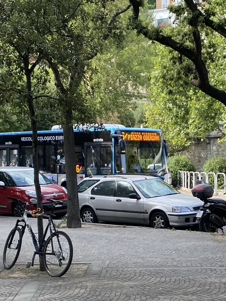
Con il 1 luglio 2022 la Trieste Trasporti (con supervisione di TPL FVG) ha deciso di rinumerare le corse della linea 6 tra Piazza Guglielmo Oberdan ed il Bivio di Miramare co il numero barrato per non creare confusione. Ho proceduto alla rinumerazione aggiungendo la /, è creato anche il nuovo route_master.
Ricordo che le corse deviate per Porto Vecchio, a sostituzione delle linee 80 (soppressa) ed 81 (sospesa nel servizio estivo) non hanno diversa numerazione, tantomeno capolinea rispetto alla 6 “normale”; allego foto scattata da me il 01/07/2022.
 Con il primo luglio entra anche nuovamente in servizio la linea 90 tra Alto Adriatico e Lazzaretto, a rinforzo della linea 7.
One of possible uses of note-viewer is browsing notes in some area. You can do this using the BBox dialog that lets you get notes in a rectangular area. This is similar to how the note layer on the OSM website work and how the editors like JOSM load notes. And it similarly won’t work if the area is too large or not rectangular. So if you want to get notes in a country, you won’t be able to get them easily. But you may know that there are services that show notes for a given country, like the one by Pascal Neis. There you can select a country and get a list of notes filtered by their status.
That’s how you can get a list of notes for a country. But what if you want to see notes on a map? The list doesn’t contain note coordinates so it can’t be done directly. The situation is similar to looking at a list of user’s notes on the OSM website, something that note-viewer was originally written to take care of. Can it handle country lists now? Actually it can handle any list with note ids. In addition to showing webpages with note lists, Pascal Neis’ site also has Atom feeds. It’s going to be easier for us to get note ids from these feeds. And no, unfortunately, they still don’t contain coordinates.
Any list in our case is an XML file, and note-viewer handling it means that it’s possible to come up with selectors for XML elements that contain note ids. If ids are inside some attributes, the names of the attributes also need to be specified. Click on the XML tab in note-viewer and look below the instructions for neis-one.org to see the inputs for selectors and attributes. You won’t have to use them if you only want to get note lists from neis-one.org, just follow the instructions above.
 Zona de estacionamiento reservada para personas con movilidad reducida junto al castillo de Gibralfaro. Fuente: trabajo propio (CC BY-SA 4.0) disponible en Wikimedia Commons.
Se están incorporando al mapa de OpenStreetMap las plazas de estacionamiento reservadas para personas con movilidad reducida disponibles en el municipio de Málaga. Se trata de una importación realizada a partir de datos abiertos del Ayuntamiento de Málaga.
This diary is for recording my progress on the program and show the effect after every edit.
1: Z-index is added to the way with the selector [partOfActiveRoute] to make the target route float on the top of the map.
on 29/06/2022 i started on remote mapping of entebbe municipality inorder to clean up the map so that it be ready for those who wish to use it and also to prepare for the fieldwork where by healthcare facilities can be added on it after capturing them by use of ODK hence helping the community to identify the locations of these facilities
CTO / Head of R&D @ Libraesva. IT security / free flight safety @ FIVL and EHPU. Expert @ CEN and UNI.
Esse foi meu primeiro projeto de importação semi-automatizada. Na maioria das vezes prefiro usar o MapRoulette para poder conferir os dados e corrigir se necessário. Isso acaba dando um pouco mais de trabalho mas isso é melhor para dados mais complexos como escolas, postos da policia, clínicas e outros dados.
Como estou sempre procurando novas bases de dados que possam ser usadas para melhorar o OSM acabei encontrando o GeoDourados, que é uma base bastante rica de dados sobre a cidade de Dourados, alem de contar com ortofotos de alta resolução.
Mandei um e-mail para os responsáveis pedindo permissão para usar os dados no OSM e, apesar de ter enviado mais de 10 e-mails para cidades diferentes, a única que respondeu foi Dourados. Por isso gostaria de agradecer ao Departamento de Geoprocessamento de Dourados, em especial ao Ênio Alencar, por ter dado suporte com esse projeto.
De todos os dados possíveis para utilização no OSM, decidimos começar pelas árvores, visto que além de ser um dado útil, seria mais simples de importar inicialmente. Não há duvida da importância das árvores para o ambiente das cidades, além de promover conforto nos dias mais solarizados também servem para absorver os ruídos produzidos nas grandes cidades.
Caso queira saber mais sobre arborização e o OSM na ultima terça feira houve um webinar sobre o OSM e arborização urbana para comemorar o dia da árvore link
O trabalho de importação só foi possível com a ajuda do Matheus Gomes que teve todo o trabalho administrativo, pedindo permissão da comunidade, escrevendo na Wiki e preparando os dados para serem importados. Sem ajuda sua ajuda não saberia nem por onde começar, obrigado!
Com os dados já prontos e com autorização, tive que começar a limpar áreas de conflito que já tinham árvores mapeadas. Usei o overpass turbo para baixar esses dados e comparei com os dados que seriam importados.
{Insert standard apology about poor english from non-native speaker here}
So, I've found this beautiful thing, the OSM, I'm feeling so inspired and motivated - finally a platform where I can make contribution and fixes knowing that my efforts will not be in vain!
I'm currently living in Gyumri, Armenia, and maps here... have issues. On Google Maps, seems that building were autogenerated from satellite images - there are obvious errors, missing buildings, nonexistent buildings, buildings with weird geometry, buildings that are crossing roads or each other, roads that in reality are footpaths, footpaths that are ending abruptly (because they are partly hidden by trees on satellite image) - you name it. Addresses are absent on 90% of buildings. In my city, all you can do in Google Maps - 'add missing place' or 'add missing address' ('fix road' option in my area is not available), by filling some form and hope that it will be accepted by somebody someday. But where should I add address if the building itself is not present on the map!?
I love it
依據高雄市政府觀光局2022.06.27發布政府開放資料 其中包含壽山國家自然公園轄管山區及高雄觀音山範圍之通訊標示 https://khh.travel/zh-tw/event/news/4565 總計61處,經比對有1處坐標有問題(已經向高雄市觀光局詢問) 其餘多數壽山國家自然公園內多是補充電信業者資訊(之前已建置遠傳和台哥大,這次多新增中華電信和亞太電信) 至於高雄觀音山為本次新增項目。
台灣政府最早由林務局羅東林區管理處與電信業者合作測試及設置通訊牌誌,並請RUDY協助匯入OSM中,隨後經累積林務局各林區管理處、玉山國家公園、雪霸國家公園、壽山國家自然公園管理處、新北市政府相關單位建置之通訊資料已達1300處,台灣登山迷途案件占山域救援案件近5成,本次增加可以補充相關電信業者,讓民眾知道哪裡可以通報,提升台灣民眾登山安全。
Hey ihr Lieben,
ich hätte gerne eine abfrage die mir die wasserwanderrastplätze in Brandenburg anzeigt.
Ich bin sehr neu in diesem Forum und nicht besonders technikaffin. Wenn mir jemand zeigen könnte, wie die abfrage aussieht, wäre ich sehr dankbar.
Un projet occupe une poignée de contributeurs OSM en Belgique: l’import des batiments, c’est-à-dire compléter tous les batiments à partir des données officielles et ajouter la référence de ces données officielles aux batiments existants.
Depuis des contacts initiés fin 2021 avec le service public de Wallonie (SPW), cet import est également disponible pour la Wallonie, sur base des données du PICC: la base de référence pour les batiments en Wallonie.
Cet article expose brièvement la méthodologie suivie et des premiers résultats sur 3 sections administratives de la commune de Neufchâteau, principalement en repérant des nouveaux batiments et des batiments détruits.
À ma connaissance, il n’y a pas eu d’état des lieux récents de la complétude des batiments en Belgique. D’une manière générale, la majorité des batiments ont été cartographiés, souvent à la main, sur base d’images aériennes (ou du fond de plan du PICC en Wallonie). Les contributeurs trouvent en cherchant un peu des communes où il manque davantage de batiments que d’autres, ou bien des endroits où les batiments devant avoir une adresse n’en ont pas. On pourrait faire une analyse plus détaillée par commune pour estimer le taux de complétude des batiments.
Quoiqu’il en soit, voici une carte de l’état d’avancement de l’import: http://umap.openstreetmap.fr/fr/map/building-import-status_714473#8/49.792/5.823; Attention, comme dit plus tôt, une majorité de batiments ayant déjà été cartographiés par le passé, cette carte ne renseigne que sur l’import récent des batiments ainsi que l’ajout des références officielles.
Dès aujourd'hui je vais écrire des journaux dans le fonctionnement lors de faire du vélo.
Denpasar
Hi, everyone!
Since this is a diary, I’ll try to keep it that way.
I am from Nepal & a Software Engineering undergraduate student at CODE University in Berlin, Germany since 2019.
That makes me a non-EU international student. Like most students in technology, I also work part-time at a startup for experience and other perks.
I like the process of creating a tech product, particularly ideation sessions, user stories & figuring out tech problems.
There were a few students who completed GSoC at our university and organized a session sharing their experiences. That made me curious. I found OpenStreetMap(OSM) from the list of organizations, mapped my home, and liked the product.
You can find my application here
Geo-referenced image viewer
User story
An OSM user takes photos of different restaurants, supermarkets, and other cafes from his/her phone on a given day
The user now wants to update the opening and closing hours of one of the restaurants with help of the photos he/she took some time ago
By dragging and dropping (or importing) those photos in the iD editor, the user wants to see all the photos on the OSM & fill out the business hours (opening and closing) side-by-side
A pictorial representation of the user story can be found here
Github or


