J’ai créé mon salon sur BigBlueButton, le lien se trouve ici: @HugoC01
Users' Diaries
Recent diary entries
RETEX: Encounters Along My Mapping Walks
(translation by ChatGpt)
to be continued, maybe:
- journal entry (upcoming): Existential Questions About My Encounter with Panoramax
- journal entry (upcoming): Existential Questions About OSM and the Wikimedia World
- journal entry (upcoming): My First Experiences With an RTK Rover and an RTK Base
My urban recycling trek is now complete (at least regarding the attempt to map all voluntary drop-off points in the GPS&O intercommunality). I still need to clear up some fixme tags. This journal entry isn’t about mapping information but simply about a few encounters I had during my walks. They are just brief flashes of emotion, smiles, or frustration.
To understand the atmosphere of these encounters, picture me as:
- 70 years old, usually in shorts (except below 11°C)
- with a backpack (20L)
- always carrying at least one hiking pole in one hand and a camera in the other
- sometimes with a pole sticking out of my backpack holding a GNSS antenna at head height
The Best of the Best: Hunting for AEDs
in a micro-crèche
2025-09-08 in Médan I’m looking for a micro-daycare facility to verify the presence of an AED (Osmose suggestion). I wander a bit around the assumed location at the end of a residential cul-de-sac and eventually identify the daycare. I hesitate to enter the garden and ring the doorbell when an educator opens a ground-floor window, leans out, and asks whether I’m looking for something and if she can help (a polite way of saying “we’re watching, please move along”).
We exchange a couple of rather friendly minutes during which I silently give up on asking whether I may come in to photograph the AED (didn’t seem very wise). Instead, I hand her my phone and ask if she can photograph the AED on their wall (at least we both know she will avoid putting any children in the frame).
Posted by oldnab on 9 December 2025 in French (Français).
RETEX : Rencontres au fil des randonnées cartographiques
à suivre peut-être :
- entrée de journal (à venir) : Questions existentielles sur ma rencontre avec panoramax
- entrée de journal (à venir) : Questions existentielles sur OSM et le monde Wikimédia
- entrée de journal (à venir) : Mes premières expériences de rover RTK et de base RTK
Mon trekking urbain recyclage est maintenant fini (en ce qui concerne la tentative de cartographie de tous les points d’apport volontaire de l’intercommunalité GPS&O.). Il me reste à régler certains fixme.
Cette entrée de journal ne concerne pas des informations cartographiques mais simplement quelques rencontres que j’ai faites au cours de mes marches. Il s’agit juste de brefs éclats d’émotion, de sourire ou de colère.
Pour comprendre l’ambiance de ces rencontres, il faut m’imaginer :
- 70 ans, en short en général (sauf en dessous de 11 degrés Celsius)
- avec un sac à dos (20l)
- toujours au moins un bâton de marche dans une main et un appareil photo dans l’autre.
- parfois une canne sortant du sac à dos et portant (à hauteur de ma tête) une antenne GNSS
Le must : la recherche des DAE
dans une microcrèche
2025-09-08 à Médan
Je cherche une micro-crèche pour vérifier l’existence d’un DAE (suggestion Osmose). Je tourne un peu autour du lieu supposé au bout d’une impasse résidentielle et finis par identifier la crèche. J’hésite à entrer dans le jardin et à sonner à la porte lorsqu’une animatrice ouvre une fenêtre (rez-de-chaussée), se penche à l’extérieur et me demande si je cherche quelque chose et si elle peut m’aider (façon de me dire “nous sommes vigilantes, passez votre chemin”).

It was a lovely day outside today. I added some fire hydrants along East Almond, and also adjusted the crossing at Almond and Center, which I believe must’ve been edited based on out-of-date aerial imagery. The previous nodes and ways specified unmarked, uncontrolled intersections for all but one crossing, which matches the existing Bing imagery. I walk through this area all the time, though, and the city installed more stop signs and painted the remaining three crossings with yellow ladder crosswalks some months back. So, I’ve updated the map to reflect this.
Some of the hydrants along (or just off of) Almond were Clow hydrants, as I’ve seen before, but instead of a more recognizable model number, these all just read “5” underneath “Clow”. A quick search didn’t turn up any “Clow 5” hydrants, although it is, admittedly, hard to Google, and I was outside on my phone when I searched.
That being said, I did another quick search just now on my computer, and I found a PDF that mentions a “Clow #5” hydrant. Mystery solved! I tagged these as “model: 5” at the time, so there’s nothing to do!
Posted by Raquel Dezidério Souto on 9 December 2025 in English.
Do you know how to map access points to the beach?
Check out the tagging scheme that we have developed for mapping access to beaches and other coastal recreational areas
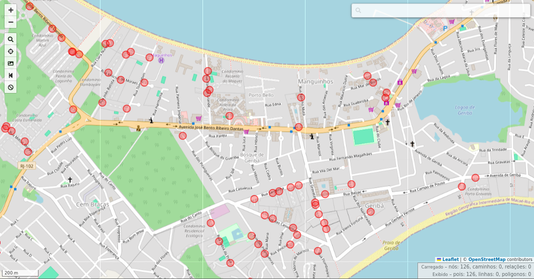
Manguinhos Bay, Armação dos Búzios, Rio de Janeiro, Brazil, viewed in the overpass turbo, filtering tag barrier=gate (red). Mapa data © OpenStreetMap contributors, Nov. 15, 2025.
Collaborative mapping of beach access with OpenStreetMap
I participated as a Keynote Speaker in the II Beach Access Network (BAN) Research Workshop, held between August 18 and 20, 2025, at Casa da Ciência, Rio de Janeiro (Brazil), and showed how to map beach access points with OpenStreetMap. Now you can read the text about the tagging scheme and some details of this mapping.
Download the text
New development completed and occupied.
Consists of:
1 - 7 Norman Close, ST. ALBANS, AL1 2DW
1 - 5 King Offa Terrace, Wallingford Walk, ST. ALBANS, AL1 2EL
18A - 18B Abbots Avenue West, ST. ALBANS, AL1 2EJ
While I mapped driveways years ago in my neighborhood, I didn’t include access tags. I saw that later someone added access=private tags, and I thought nothing of it assuming it was the correct tag. So now when I just mapped scores of them in the neighborhood additions, I just now had the thought to look on the wiki for the tag definition.
As said by the wiki, the definition of access=private:
Public access is not allowed. Access is granted with individual permission only. Examples: A driveway with a no trespassing or keep out sign; A company parking lot for employees only. “Individual permission” has been interpreted to also include delivery people making a delivery to a resident or drivers picking up a resident by request.
Most of that makes sense - but in the examples, why would it specify a driveway would need a “No Trespassing” or a “Keep Out” sign? Just wondering if I need to retag some driveways in line with common (or changing) practice, or at least having more confidence in tagging them correctly.
地震があったね 震度6強 12月9日
قمت بتعديل جديد وقمت بإزالة بعض الأماكن التي بالفعل تم نقلها إلى مكان آخر ولا يوجد تغيير في الخريطه هل تأخذ وقت طويل في تنزيل بيانات الجديده؟ كل ما اتطلع اليه هو تقديم بيانات دقيقه فقط للمستخدمين
Posted by theorangetheme on 7 December 2025 in English.
Last updated on 9 December 2025.
Not much to report today. I stopped by Play Coffee with a friend and added some POI tags while we were in line. There’s always something to map if you have a little downtime!
I also discovered that the building Cali Tacos is in has no POIs to speak of, so I’ll focus on adding those next, along with ever more fire hydrants. (I found some possibly interesting information about Van Deventer fire hydrants, but I’m not sure it’s enough to answer the question firehydrant.org posed about whether or not it was a company or just a licensed design.) In fact, the geometry on the map just shows one singular building, which is true, but there are individual units for each business. I think it makes sense to break them up, I just need to make sure I’m doing it correctly.
Using a phone running Android OS as a data collector for an RTK-enabled GNSS receiver, I ran into a fairly small but annoying inconvenience with getting data files from it on a Windows machine.
On Windows, you can’t mount a phone’s file system as an actual removable drive (don’t confuse that with seeing its file system in the File Explorer), so automating it with built-in command-line file tools isn’t an option. File paths to the data folders of Android apps are ridiculously long, so traversing them manually is another hassle.
However, it’s still possible to do that using the Android Debug Bridge tool, a part of the SDK Platform Tools.
After installing SDK Platform Tools, you should be able to use the adb command in PowerShell or classic Command Prompt batch files.
Knowing the full path to a folder where your data collector app (LocusGIS, SW Maps, etc.) stores files you need to download regularly, you can get a list of that folder’s contents by calling adb shell ls command with the full path to that folder as a parameter.
Downloading a file is as easy as calling adb pull with the full path to the file you want to download. This process can be made more or less interactive if you create a script that lists all the folder contents, then prompts you for a name, and then downloads the file by the name you entered. The target file name or path can also be specified as another parameter. It’s even easier if the data collector app uses the same filename every time, or if you save it under the same name.
For all that to work, you’d have to enable USB debugging on your mobile device and grant permission for the Windows machine to use it when you first attempt to utilize the adb. However, it would save you the hassle of switching on the File Transfer mode every time you want to access the phone’s file system.
x

Initial Situation
In the forum, a user reports that a road on Crete is not being displayed completely. It quickly becomes clear that the German style is being used for rendering.
Openstreetmap.de operates two tile servers. On both of them, the tiles are faulty. It would be quite a coincidence if this were a hardware issue or a specific data import problem. Therefore, it is very likely that the cause lies within the German style itself.
The only difference between the two road segments is that the visible part contains one additional tag, namely maxspeed:
First Attempt
In the first attempt, I added a tag, namely the surface surface, to the missing segment and forced the German server to re-render the tiles. As a result, the previously missing part of the road appeared. This brought me one step closer, but it is not a solution yet.
Second Attempt
The German style is based on the standard openstreetmap-carto style, which is used on openstreetmap.org for OpenStreetMap maps. It adopts the basic rendering but selectively modifies certain elements to make them more readable for Germans.
I was curious whether the missing road segments were also absent in the original style. Therefore, I rendered them using that style. For this, I used render_single_tile.py and retrieved the necessary information by right-clicking on the corresponding tile at https://tile.openstreetmap.de.
First, I rendered with the German style, where – as expected – the road section was missing:
render_single_tile.py --zxy 17 74577 51762 --stylefile openstreetmap-carto-de/osm-de.xml --outputfile site/rendersinglefile/1.png
Then with the original style, where the rendered tile was also incomplete:
render_single_tile.py --zxy 17 74577 51762 --stylefile openstreetmap-carto/mapnik.xml --outputfile site/rendersinglefile/3.png
Hello, guys. I am trying to map a neighborhood of León, in Spain. I need a lot of help, as there are plenty of buildings not mapped or not mapped correctly, so any help would be much appreciated. This is the note where you can see the area that I am working on right now. note/5052568#map=15/42.59710/-5.56225&layers=N

Name:
2025 12 06 37,50 #SchwarzerBulle DE NW Etwas krank Rad gefahren
Fahrt:
2025 12 05 42,30 #SchwarzerBulle DE NW Schwarzer Bulle Testfahrt Nordrandweg und Terranova Speedway
Sziasztok!
Az élet sodor, gyakran mint egy hurrikán. Ugyan kevés olyan időm akad, amikor OSM-el tudok picit foglalkozni, gyakran fut át a fejemen, hogy ezt-azt megnézek a térképen a környezetemből és majd javítom, szerkesztem, ha eltér. Nyilván ettől sokkal kevesebbszer érek oda, de azért párszor már összejött.
Továbbra is érdekel és fogok is szerkeszteni.
Néha még a JOSM-ot is frissítgetem az aktuális verzióra, akkor is, ha közben mégis az ID-n egyszerűbb és gyorsabb valamit igazgatni. A kis dolgoknál ez így is marad, de ha nagyobb varázslat szükséges, a JOSM is jó, látom, ha nem is sűrűn, de még mostanában is frissítették.
Az OSM továbbra is kedvenc koncepció a szememben és örülök, hogy jó ideje stabil és fejlődik.
Üdv, V.
It was another beautiful, sunny day in Orange. I’m toying with the idea of conjuring up some sort of regular Saturday mapping activity, solely so I can use the word “Mapurday”, even though I’ve mapped at least one thing every day for the last five days. I’m sure that will slow down a bit once I re-balance the other parts of my life (although I did add a bench in Riverside last night while waiting for a friend to arrive; it doesn’t take much to contribute!). I’m not sure if it will be just for myself, or I want to try to get other local mappers involved.
It was a productive day! My goal was to add more fire hydrants along Palmyra, and to catch one I had somehow missed along Almond. I can’t say it’s representative, but so far, the manufacturers have all been one of:
- Rich Valve Co. (or Rich Manufacturing Company; I’ve seen both and other variations in newspaper clippings)
- M. Greenberg’s Sons
- Long Beach Iron Works
- Clow (Valve Company)
There’s also one Van Deventer, which firehydrants.org says could be a company, but it could also just be a fire hydrant produced under license. I plan to do a little newspaper digging to see if I can learn more.
Orange Street Barbershop
I added the Orange Street Barbershop to the map. I’ve been correcting several missing or otherwise out-of-date business POIs in addition to my quixotic hydrant mapping quest. The previous salon for 120 S Orange St was long since closed, so I updated it for the new business. I also noticed that the entire building was marked as the salon (now barbershop). I switched this to an individual node because the Orange Street Barbershop is technically suite B; there’s a suite A with doors set a bit back into a covered part of the building, but they don’t seem to be for anything useful.

YIPPIEEEEEEEEEE! I’m already at 65 edits! This is the start of something very great and beautiful. Speaking of great and beautiful, I love my girlfriend so much!

Es absolutamente maravilloso.