
Hello OSM friends! I’m Bhausaheb…… from Nashik, working in GIS Industry as an GIS Engineer. Recently, I have been mapped new buildings around my locality using ID Editor.
Users' Diaries
Recent diary entries

(My first diary entry, am I doing this right?)
I’ve been mapping my beautiful town for now 1.5 or more years. I discovered OSM through a Polish youtuber talking about motorways, and at first I made some small changes, not knowing what I got myself into. Through the years, I’ve fixed the landuse, updated all of the POIs, kept up with constructions, repairs, etc., and did all sorts of detailing.
I’ve reached a point where… I need to move outwards. There is not much left to do except wait for something to close, open or change.
It’s been a heck of a ride. I would like to give the Polish OSM community a warm thank you for helping me out in sticky situations.
Link for the map, go explore!
Hello OSM friends! I’m Pratap from Mumbai, working in GIS. Recently, I mapped new buildings in my locality using iD editor and did QA checks with OSM Inspector. I’m excited to share my learning with the community

안녕하세요
가산동 라이브 방송 스튜디오 세븐시스템 입니다 페북 체크인 관련건으로 만지작 거리다 여기까지 오게 되었네요
즐거운 하루 되세요
질문요 ! 오픈스트리트맵 앱은 없나요? 아이폰 스토어에서 검색해도 안나오는거 같던데

Lifecycle Tagging
Lifecycle tagging is the representation of the temporal state of an object (e.g., whether it is under construction, demolished, or abandoned). Since there is no single convention universally accepted by the community, different and inconsistent schemes have developed, making automatic interpretation and uniform data management difficult. In many map editors, there is no section dedicated to editing this lifecycle, which makes it even more difficult for new users to understand how to use the system.
The goal of this project is to devise and implement a method for applying lifecycle tagging in a way that is simple, intuitive, and does not interfere with existing tagging practices.
PR can be viewed here.
Study
Before fully committing to the development of a new interface, a study was conducted to assess which tagging schema is the most popular, consistent and suitable for integration into the iD editor. Many other editors have been. Full study available here.
I also tried many of the existing editors and checked how they supported lifecycle editing.
Proposed Standard
오늘부터 합류하겠습니다! 화이팅!!
Posted by ignaciolep on 4 September 2025 in Spanish (Español).

Después muchas pruebas, les comparto un método para realizar las correcciones de manera masiva y controlada. Este flujo de trabajo es el más simple, rápido y seguro que pude lograr.
⚠️ MUY IMPORTANTE:
- Seguí las instrucciones paso a paso. El orden de los reemplazos es importante.
-
No mezcles las dos tareas (
networkyref). Hacelas por separado y subilas en changesets distintos.
Requisitos:
- Un editor de texto que soporte “Buscar y Reemplazar” con expresiones regulares (RegEx). Notepad++ es perfecto para esto.
- JOSM instalado y actualizado.
Tarea 1: Normalizar la etiqueta ref
🎯 Objetivo: Quitar los prefijos “RN” y “RP” de la etiqueta ref en todas las relaciones de ruta.
Paso 1: Obtener los datos desde Overpass Turbo
Vamos a descargar un archivo .osm que contiene únicamente las relaciones que necesitan ser corregidas.
- Andá a overpass-turbo.eu y pegá la siguiente consulta.
-
Modificá la línea
{{geocodeArea:...}}para poner la provincia en la que querés trabajar (recomendado).
[out:xml][timeout:180];

// Reemplazá "Jujuy" por la provincia que quieras.
{{geocodeArea:Jujuy,AR}}->.searchArea;

// Para buscar en toda Argentina (puede ser muy pesado y lento)
// area(3600286393)->.searchArea;

(
  rel(area.searchArea)
     ["route"="road"]
     ["ref"~"^R[NP]"];
);

out meta;
- Hacé clic en “Ejecutar”. Ante el aviso de “Datos incompletos” hacé clic en “Mostrar datos”
- Una vez que termine, descargar los datos como OSM XML, andá a “Exportar” > “datos OSM sin procesar”. Guardá el archivo como
refs_para_editar.osm.
Paso 2: La Edición Masiva en Notepad++ (en 2 reemplazos)
Posted by raphaelmirc on 3 September 2025 in Portuguese (Português).
📢 Venho compartilhar com vocês o Material de Apoio do Projeto Mapeia Crato/CE 2025.
Neste material, você encontra um passo a passo completo para o mapeamento das edificações (buildings) utilizado no projeto, organizado de forma prática e acessível. O conteúdo está disponível em três formatos: ODT, PDF e uma apresentação em MP4, para que cada mapeador possa escolher a melhor forma de aprender e aplicar.
👉 O material pode ser baixado diretamente no site do projeto:
Posted by raphaelmirc on 3 September 2025 in Portuguese (Português).

🚀 Venho compartilhar o Material de Apoio do Projeto Mapeia Crato/CE 2025!
📂 Disponível em ODT, PDF e MP4 🏠 Passo a passo para mapear edificações (buildings) 🌍 Pode ser usado em qualquer projeto com dados do Open Google Buildings ⚡️ Fluxo de trabalho simples e produtivo
📥 Baixe agora: umbraosm.com.br/projeto-mapeiacrato
SIWES Diary – Day 1 Date: 2nd September, 2025 Organization: Unique Mappers Network, Nigeria National Office: Suite 7, Mapathon Center, UNIPORT Mall, Abuja Campus, University of Port Harcourt
Activities:
-Reported to the National Office of Unique Mappers Network and settled into the Mapathon Center.
-Was introduced to the organization’s vision, mission, and the role of open mapping in sustainable development.
-Met fellow IT students including Favour, Alexander and Salvation, who are also undergoing their internship.
-Created an OpenStreetMap account and was tasked to locate my community and count the number of buildings. Many buildings were not visible, so using aerial imagery and my local knowledge, I edited the map by adding missing buildings.
-Since the office router had no internet subscription, I used my personal data for mapping and contributions.
-Received four major tasks for the internship period:
-
Watch the video “The Magic of Maps and Mapping” (YouTube link-https://youtu.be/5MyCtvSBATI?si=g6TM60pmY_oolnT) and reflect on how mapping can be applied to geology.
-
Work on mapping buildings in my community, since the area is not yet globally visible on OpenStreetMap.
-
Research and design an open mapping project that addresses at least five Sustainable Development Goals (SDGs).
-
Participate in research-related tasks assigned by the organization.
-Later in the day, I met the National Coordinator, Dr. Victor N. Sunday, who gave me a formal orientation. He emphasized the importance of my contributions and provided me with a WhatsApp link to join the National Community and Internship groups. Observations/Learning Points:
-Understood the operational structure of Unique Mappers Network and how it collaborates nationally on geospatial projects.
-Learned the importance of open data contribution to global platforms like OpenStreetMap.
Der Datensatz “WMS LGL-BW ALKIS” enthält liegenschaften und Hausnummern.
TL;DR;
Auszug Rechtliches in https://www.lgl-bw.de/Produkte/Open-Data:
Die offenen Geobasisdaten und Geodatendienste der Vermessungsverwaltung Baden-Württemberg können unter den Bedingungen der Datenlizenz Deutschland - Namensnennung - Version 2.0 (http://www.govdata.de/dl-de/by-2-0) unentgeltlich genutzt werden. Die Namensnennung hat in folgender Weise zu erfolgen: “Datenquelle: LGL, www.lgl-bw.de, dl-de/by-2-0”.
Details
Es gelten die Nutzungsbedingungen aus den Metadaten
Dort ist die liberale https://www.govdata.de/dl-de/by-2-0 zitiert, als auch die (nicht so liberale) AGB
Zu Luftbildern gibt es eine Freigabe zur Nicht-Nennung.
Lesenswert ist auch die Anfrage.
Im Tagungsband der FOOSGIS 2025 steht auf Seite 56: Baden-Württemberg gehört zu den Bundesländern, die mit Inkrafttreten der Durchführungsverordnung ihr Open Geodata-Angebot um ALKIS [10] erweitert haben. * Lizenz (Download und Dienste): Datenlizenz Deutschland – Namensnennung – Version 2.0 (DL-DE→BY-2.0) [11]
Nach der stehen die Daten im Geoportal unter der “Creative- Commons-Lizenz CC-BY 3.0”.
Laut osm.wiki/DE:Permissions wurde eine Anfrage bei der LGL BW zur Radkarten nicht beantwortet.
Posted by tukangsampat on 2 September 2025 in English.
In 2025 alone I found vandalism incidents specifically targeting map of Indonesian parliament compound twice, in March and now in late August. Thankfully these are all restored.
What made me sad that some Indonesians don’t understand the OpenStreetMap at all, what they only know in their head is political activism. They do by erasing - or editing - the place of institution they despise. Not really sure if these incidents are unique to maps in Indonesia or there’s international example of politically motivated vandalism of OSM maps?
Posted by tukangsampat on 2 September 2025 in Indonesian (Bahasa Indonesia).
Last updated on 6 September 2025.
Memang repot menghadapi sebagian netizen Indonesia yang sepertinya menyalahgunakan peta sebagai alat perjuangan politik ketimbang bantuan navigasi dan informasi.
Selama delapan bulan terakhir, vandalisme bernuansa politik sudah dua kali terjadi: Maret 2025, dengan mengubah batas wilayah negara (yang mungkin gampang diketahui oleh pengurus OSM); dan Agustus 2025 dengan mengganti dua tempat menjadi reservoir.
Target utamanya kalau tidak lain dan tidak bukan kompleks DPR/MPR, khusus untuk Agustus 2025 juga menimpa peta kawasan Polda Metro Jaya (DKI Jakarta). Jika anda punya ketidakpuasan politik di Indonesia, jelas OpenStreetMap bukan tempatnya dan yang anda hadapi adalah dihukum oleh pengurus OpenStreetMap. Mungkin ini satu-satunya vandalisme bernuansa politik di OpenStreetMap
(Update 06/9/2025 - sebenarnya bukan, cek kolom komentar di diari versi Bahasa Inggris, dimana disebut terjadi vandalisme besar-besaran di peta Rusia dan Ukraina terkait perang, serta kasus vandalisme peta TMP Fort Bonifacio di Filipina akibat politik domestik).
Jika anda berpolitik, cobalah untuk menulis di media sosial dan jangan bikin repot orang lain.

Styles for vector tiles are typically written in the MapLibre GL style language. These definitions exist in JSON, which, for various reasons, is not a good language for humans to write in. Software called Charites preprocessed my Street Spirit style to improve readability. This helped a great deal and removed the two largest pain points: no comments and only one file.
Charites’ main features are:1
- letting you write in YAML instead of JSON,
- importing other YAML files into the main one,
- and the use of simple variables to allow common style constants to be set once.
I made use of the first two features, but I still found myself limited by them. I still faced issues where the project’s structure revolved around the styling language rather than what makes sense to a cartographer.
A good example of this was road layers. With Charites I had to have separate files for each layer, so I had separate files for each of the thirteen layers. With glug I was able to have one file for the twelve layers that drew the casings and fill, and one file for the road text layer. This kept related definitions in the same place, which makes everything more readable.
Expressions are essential for writing performant MapLibre GL styles. A simple expression example is filtering to only show labels of larger areas. A filter property such the one below does this.
{"filter":
[">=",
["get","way_area"],
['*', 750, 6126430366.1, ['^', 0.25, ["zoom"]]]
]}
This JSON doesn’t allow comments, so you have to hope it’s obvious from the text what is happening.[2]
Charites lets this be reformulated to YAML
filter:
  - '>='
  - [get, way_area]
  - ['*', 750, 6126430366.1, ['^', 0.25, [zoom]]] # Only show areas larger than 750 pixels at current zoom
It’s a bit better, but the comment shows a limitation of the language. Filtering by area is a very common task. It shouldn’t require a comment to explain the basic math. With glug this instead becomes
OSM Accounts
same login:
https://wiki.openstreetmap.org/wiki/User:XXX
https://community.openstreetmap.org/u/XXX

different login:
https://www.openstreetmap.org/user/XXX
Integrations:
Services
- Github
- Umap
- Facilmap
- Overpass
- Geojson.io
Desktop Applications
- josm
- gnome-maps
Android Applications
… TODO
Posted by DressyPear4 on 1 September 2025 in Brazilian Portuguese (Português do Brasil).
Last updated on 23 November 2025.

Desenhá-los de forma individual, além de correto, proporciona um visual mais agradável.
À primeira vista pode parecer desafiador, devido à quantidade e disposição dentro de uma planta solar.
Desenhar um painel e iniciar um processo de copiar e colar não é uma boa prática, pois é muito difícil acertar a posição para que fiquem espaçados e alinhados entre si.
Então, como fazer?
Gridify
Desenhar o contorno de um bloco e usar esse plugin garante tamanho e espaçamento iguais para todos.
- Para o caso em que os espaços têm a mesma largura dos painéis, a contagem é:
T x 2 - 1(ondeTé o total de blocos). - Para o caso em que os espaços têm o dobro da largura dos painéis, a contagem é:
T x 3 - 2.
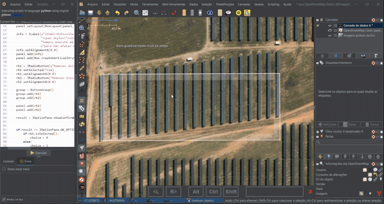
Um ponto negativo do Gridify é que não há opção para adicionar apenas os blocos necessários, sendo preciso remover manualmente os blocos que ficam nos espaços internos — uma tarefa bem trabalhosa se houver muitos painéis.
Então, como agilizar?
Scripting
ตำหนักแพหรือท่าราชวรดิฐ
Posted by RobotFK on 1 September 2025 in German (Deutsch).
Last updated on 2 September 2025.
Wenn mal nicht klar ist was gemacht wurde die folgende Url nutzen und die Changeset ID am ende anhägen:
https://facilmap.org/#q=changeset%20
Wiki Eintrag dazu.

Hi everyone, this is the update on the final phase of my project in adding transliteration support to Nominatim’s search results! A quick refresher: this project focused on adding transliteration as an option to users who did not understand the local language of a name, in which an understandable tag was not available.
Background
For background, you can check the overview of the project and the midterm report down below:
The bulk of the work can be found in these pull requests:
- Locales and result class refactorization
- Locales documentation update (for refactored code)
- Transliteration integration
Detailed Report of the Project
The detailed version of the report can be read here (version pending Github Commit).
What I did
- Integrated transliteration into Nominatim so search results in unfamiliar scripts (e.g. 北京市) can be displayed in a user-readable form (e.g. Beijing).
- Built a pluggable transliteration framework supporting Latin script via unidecode, with prototypes for Cantonese, Simplified Chinese, and Traditional Chinese.
- Refactored the
Localesclass and results pipeline for clearer responsibilities, modularity, and maintainability. - Introduced a
languages.yamlconfiguration file for language normalization and country-language mapping. - Implemented new logic for parsing browser language headers, including handling of ambiguous codes like zh.
- Wrote extensive unit tests and updated GitHub workflows for optional dependencies.
- Added documentation to explain the new localization and transliteration system.
Possible Next Steps
A summary of a few possible next steps are below:
- Improve regionalization (e.g. Hong Kong and Macau, which Nominatim does not yet recognize as independent from China).
- Refine fallback logic when multiple languages are present.
- Extend the non-Latin transliteration framework with more language-specific implementations.
- Expand testing for robustness and reliability.