Japan 🇯🇵🇯🇵🇯🇵
Users' Diaries
Recent diary entries

It would seem that wine bars match the description for an “amenity=pub”.
It resonates strangely.
I have used bar in the past but feel kind of dirty for doing that because they often are not lively and standing room only.
They are more like cocktail lounges than bars but how are cocktail lounges tagged?
Even cocktail lounges seem more like pubs than bars.
These “bars” sans lively atmosphere in possession of available and comfortable seating are another creature.
What is the alternative?
Posted by Melhorias no Piemonte on 16 February 2024 in Brazilian Portuguese (Português do Brasil).
Visando o importante Município de Saúde, um grande polo turístico e econômico regional. O Município é também o mais importante para a história da região, pois foi nele que os primeiros índios Payayas chegaram e fundaram seus povoados, e posteriormente, os bandeirantes paulistas. Em meio a Mata Atlântica e Grota, a vegetação é verde e encantadora. Saúde é um grande município agricultor, com foco nas bananas, trigo, leite, mel, caqui, etc… Saúde também é repleto de minérios, por isso, existe diversas mineradoras legais, e infelizmente, ilegais. Infelizmente, o contrabando de minério é muito comum em Saúde, e acaba adoecendo os cidadãos que trabalham em meio ao perigo da mineração ilegal. Além de contaminação dos rios, que foi o que aconteceu com o Rio Payaya, devido a uma mina ilegal de diamante.
Saúde é um importante município da Região Piemonte Norte da Chapada Diamantina, em contexto de história, religião, natureza, turismo, economia e influência.

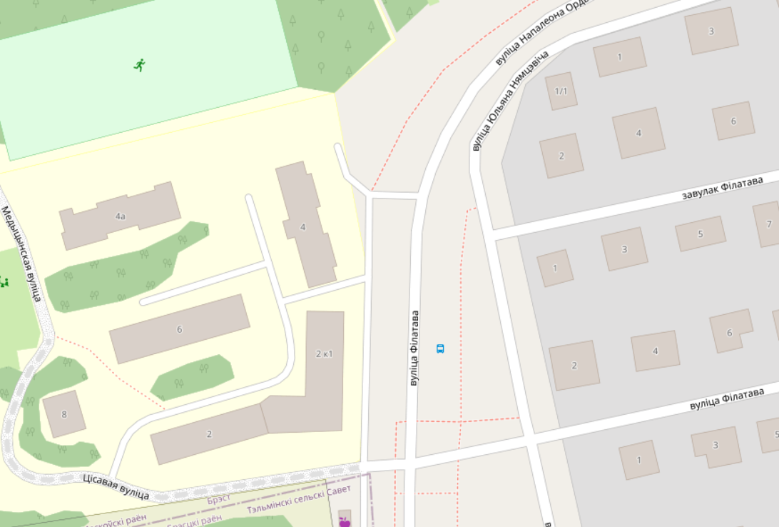 На скриншоте присутствуют:
- улица Наполеона Орды
- улица Филатова
- переулок Филатова
- улица Тисовая
- улица Медицинская
- улица Немцевича
И у зданий весьма неочевидная принадлежность к улицам. Не каждый Друзь сможет в эту логику.
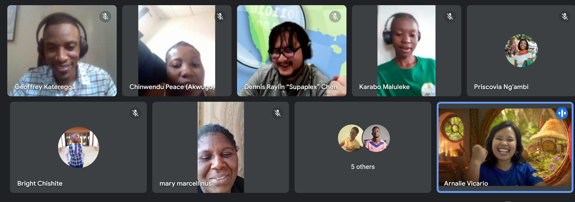
We had a meeting with Arnalie on the membership drive in OSMF.
Posted by Brazil Singh on 14 February 2024 in English.

YouthMappers at Eastern University recently organized a dynamic and engaging day-long session focused on the theme ‘Connecting with Community: Let’s Switch to Mapping.’ The event, held on February 07, 2024, at Eastern University, brought together students, and community members to explore the power of mapping in community development and engagement. The session featured a diverse range of topics, including Community Development, Leadership Training, Women’s Participation, Problem-Solving, Kobo Toolbox, Data Collection and Analysis. Led by Youthmappers Regional Ambassador, Amena Rashid Bania, the session provided valuable insights and practical skills for participants to enhance their understanding of mapping technologies and their applications in community initiatives. In addition to the informative sessions, the event also included hands-on workshops on Mobile Mapping conducted by regional ambassador Nishan Ariyal, and Mapping Techniques led by Brazil Singh, President of YouthMappers at Eastern University, Bangladesh chapter. Brazil Singh, a prominent figure in the OpenStreetMap (OSM) community, is recognized as an Open Mapping Guru Fellow in the Asia Pacific Region, bringing a wealth of experience and expertise to the session. Guest Speaker Sawan Sahriar, regional Ambassador of Youthmappers, graced the event with his presence and delivered an inspiring talk on OpenStreetMap and Mapping Tasks. His insights and knowledge added a valuable dimension to the session, inspiring participants to explore the possibilities of mapping in community engagement.
Posted by arnalielsewhere on 14 February 2024 in English.
my prolonged OSM diary about my experienced as an OSMF board member. Apologies for the delay!
Some background and tips to prepare as a board member
I joined the OSMF Board in Dec 2022 and this is my first time to hold a board member position! You can check my manifesto and answers to board election questions. I’d like to go back to this to check my progress and what needs to improve.
Since it is a new role, it really is intimidating at first! Even though I have talked with other open community and geo board members, it is different once you are in!
Some of the best tips I got are:
- Talk with leaders and people you know who have board member experience, learn from them and would be good if they can support / mentor you :)
- There is a free board member essentials available online (e.g. this Nonprofit Board Essentials from disasterready.org) so better try it and have an assessment of you board member potentials (don’t get too pressured, you will learn as you go!)
- Be a board member while you still have the time and capacity :) I am a full time mother and working woman so it was a hard decision to make; but then I realize, if I want to be a board member, I’ll better do it now since I have the capacity and interest! :)
- Two years seems like a long time but not really! You will have ideals and goals so better make that best out of it!
- Also remember, change takes time. Don’t overfrustrate yourself ;)
What happened in 2023, then?
Last year came by so fast. I am not so proud of what I have accomplished as a board as I have had some health challenges. It was a learning experience (the success and failures) for me!
With support from fellow board members, working groups, and community members, in 2023, we have accomplished:
1.Local Chapters Application revisions
Posted by arnalielsewhere on 14 February 2024 in English.
Providing updates! The OSM Wiki of the OSMF Membership Drive Campaign 2024 Plan is in the wiki: osm.wiki/OSMF_Membership_Drive_2024
We will also provide updates and have a space for feedback in the Community Forum using this thread: https://community.openstreetmap.org/t/updates-osmf-membership-drive-campaign-2024/109280
First Volunteers Meetup - 3 Feb
After a successful and overwhelming response on the Call for Volunteers, we held our first volunteers meetup last 3 Feb!
Posted by Longhorn256 on 13 February 2024 in English.
Last updated on 19 February 2024.

I’m currently in the process of tagging historical highways in Venango County. Unfortunately, there’s no online database or public PennDOT sources for old legislative routes in Pennsylvania other than historical County Type 10 maps. I will attempt to use this diary to create a listing of old legislative routes and their modern LRS equivalents within Venango County as I add the appropriate old_ref:legislative tags to OpenStreetMap and add the road to Open Historical Map.
History and Description
Legislative routes were formed from the Sproul Road Bill in 1911 and existed until 1987 when the current location referencing system became in use.
Database
This week’s weeklyOSM #707 wonders aloud whether Flørauden is the most heavily tagged node in OSM. Why wonder when OSM query engines like QLever can tell us for certain?
In fact, at a mere 283 tags, this lighthouse is a featherweight compared to the top ten nodes, which are all https://wiki.openstreetmap.org/wiki/Tag:place=country nodes weighed down by linguistic and diplomatic considerations. The most heavily tagged node of any kind has a well-known name, alt_name, official_name, and old_name in many languages.
Excluding https://wiki.openstreetmap.org/wiki/Tag:place=country, most of the top ten nodes are https://wiki.openstreetmap.org/wiki/Tag:place=city and https://wiki.openstreetmap.org/wiki/Tag:place=continent nodes. But the node in sixth place caught my attention: some 250 tags on a children’s clothing store, mostly about payment methods. One is only left to wonder if a customer, paralyzed by all the options, may resort to bartering. This vandalism was removed three weeks ago, but QLever hasn’t updated to a newer Turtle extract that contains the fix.
Excluding all https://wiki.openstreetmap.org/wiki/Key:place nodes, the now payment-ambiguous clothing store, and a duplicate Sri Lanka node that was accidentally stripped of its https://wiki.openstreetmap.org/wiki/Tag:place=country tag (now fixed)… the other most heavily tagged nodes are all seamarks – lighthouses and lighted beacons.
Flørauden was 16th among seamarks until it shot up to the top a couple weeks ago. Now, with 27 different seamark:light objects tagged on it, no other seamark comes close to it in the number of seamark:light:* subkeys.

- I. Naprawianie uwag i problemów wypluwanych przez OSM. W większości nowe tagi dla przejść dla pieszych i wikidata dla niektórych obiektów, poza tym, różne drobne poprawki. =^..^=
- II. Mapowanie południowo-środkowych części miasta; bezdroży, dróżek, wału i terenów zalewowych. =^..^=
- III. Dokładniejsza lokalizacja i dodane metadane obiektów w okolicy strzelnicy sportowej “Reduta” =^..^=
- IV. Dodano POI w okolicy strzelnicy. =^..^=
- V. Naniesiono na mapę nieistniejące wcześniej drogi i nasypy. =^..^=
͡⎚Ꮂ ͡⎚
What appears are two separate man-made geoglyphs, 300m x 500m (human) and 200m x 200m (bull), of what appears to be etched on a gently graded terrain is a human and a bull oriented north to south. The two figures is targeted with several concentrically oriented Nazca lines.
14°47′38″S, 75°4′15″W -14.7940031, -75.0709680 Nazca, Province of Nasca, Ica, 11401, Peru
The figures suggest a man-made geoglyph of a human being chased by a bull which appears to be in pursuit of him It is very unclear why the bear is chasing him. The man appears to be carrying a blanket, wearing lose fitting outfit and wearing shoes. The bull behind him has long pointy horns and appears to be drawn as if he is chasing him.
Awaiting better mapping to confirm additional linework.
Along with the inhabitants, bulls have been recorded in these local areas.
Ich, opasto,war altershalber längere Zeit nicht mehr aktiv. Nun wollte ich mich mal wieder einschalten. Also Firefox aufgerufen, Konto OSM aufgerufen, Benutzername und Passwort sind schon voreingestellt, Anmelden: Nun heisse ich plötzlich dan34 und habe mit den dort gezeigten Beiträgen nichts zu tun. Ich bin also mit richtigem Benutzername und meinem dazugehörenden Passwort bei einem falschen Benutzer gelandet. Ist mein Benutzername wegen meiner längeren Abwesenheit freigegeben worden und dan34 hat sich zufällig mit demselben Benutzernamen und Passwort neu angemeldet? Sehr unwahrscheinlich! Anderer Zugang: osm.org/ rechts oben ist opasto voreingestellt, gehe zum heimatstandort: Der wird korrekt gefunden. Auch andere Daten über diesen Zugang stimmen. Nun habe ich meinen Eintrag für OSM in Firefox untersucht: Und der lautet jetzt tatsächlich osm.org/login?referer=%2Fuser%2Fdan34 Wie kann sowas geschehen?? Nach meiner Erinnerung habe ich mit dan34 nie etwas zu tun gehabt. Ob ich irgendwann mal einen Beitrag von dan34 gelesen habe? Dies übersteigt mein Erinnerungsvermögen.

تولید کننده شستی آسانسور
KGV- Am Wiesenquell e.V.
Posted by Raquel Dezidério Souto on 12 February 2024 in Portuguese (Português).
Last updated on 8 March 2024.
Our participation in the Open Data Day YouthMappers at UFBA 2024
Nossa participação no Open Data Day 2024 do YouthMappers at UFBA
Web map do mapeamento colaborativo para redução de riscos e desastes (RRD)
Web map of colaborative mapping for the Disaster Risk Reduction (DRR)
Mapear POI no OpenStreetMap e exibir dinamicamente com uMap
Mapping POI in OpenStreetMap and displaying dynamically with uMap
V Olimpíada Brasileira de Cartografia incluiu o OpenStreetMap como parte de sua etapa prática
V Brazilian Cartographic Olympiad included OpenStreetMap as part of its practical stage
Geocodificação com OpenStreetMap
Mapeamento humanitário e OpenStreetMap
Nossa participação no State of the Map Brasil 2023
Atualização dos dados populacionais dos municípios brasileiros no OpenStreetMap
Posted by Raquel Dezidério Souto on 12 February 2024 in English.
Last updated on 15 February 2024.
Information for the disaster risk reduction (DRR) in the Municipality of Maricá (Rio de Janeiro, Brasil)
Contextualizing
This web map is part of the development research that aims to provide a mapping platform for official and collaborative data, within the scope of disaster risk reduction (DRR), as this type of catastrophic events is increasing its frequency of ocurrence in the state of Rio de Janeiro (Brazil) in the last years. The municipality of Maricá is the pilot area of interest (AOI). The reader can also visit the dynamic map of this same area of interest at uMap.
The mapping and development of the collaborative platform are coordinated by Dr. Raquel Dezidério Souto (IVIDES.org), in cooperation with a group of mappers of the YouthMappers UFRJ. To keep contact, please, send an email to [email protected] or answer this form.
Posted by Raquel Dezidério Souto on 12 February 2024 in Brazilian Portuguese (Português do Brasil).
Last updated on 30 April 2024.
Informações para redução de riscos e desastres (RRD) no município de Maricá (Rio de Janeiro, Brasil)
Contexto
Este web map faz parte da pesquisa em desenvolvimento, que visa disponibilizar uma plataforma de mapeamento dos dados oficiais e colaborativos, no âmbito da redução de riscos e desastres que têm ocorrido no estado do Rio de Janeiro (Brasil), tendo o município de Maricá como área de interesse (AOI) piloto do projeto. Visite também o mapa dinâmico desta mesma área de interesse no uMap.
O mapeamento e desenvolvimento da plataforma colaborativa são coordenados pela Dra. Raquel Dezidério Souto (IVIDES.org), em cooperação com o grupo de mapeadores do YouthMappers UFRJ. Para entrar em contato, envie e-mail para [email protected] ou preencha este formulário.
Yesterday I mapped two parks along 43rd which I decided would be the final portion - 43rd does continue east of I-435 but in the interest of some kind of coherent boundary to my city mapping, I’m keeping it within the bounds of I-435. The parks had several amenities like sports courts, picnic shelters etc. On the way between one park and another, I encountered a bar owner who wanted to chat. He noticed me taking a photo of a downed pedestrian signal button and complained about all the accidents that happen outside his bar - including the one that led to that particular damage. I reported it on the city’s 311 app and asked him if he was aware of the app - he wasn’t, so I showed it to him in case he wanted to report more accident damage in the future. A kind old man driving through one of the parks asked me if I was with Parks and Rec, and said he hoped they would add a public restroom to the park one day. I told him I agree, but explained I was just doing a hobby and not with Parks and Rec.
Several times when I have added milk churns stands to the map in Latvia, I have noticed ponds in the vicinity of farms. For a while, not knowing much about Latvian culture, I thought they were for keeping fish for a balanced diet.
But today, after having added two more MCS, I decided to ask my trusted Latvian on Instagram, the lady who has the account which features Latvian milk churn stands. She explained that rural farms often still have a sauna and that people also like ice water bathing, so it’s convenient to have your own pond on the farm. The little sauna hut (not mapped much in Latvia, but in Finland as https://wiki.openstreetmap.org/wiki/Tag:building=sauna, https://wiki.openstreetmap.org/wiki/Tag:building:use=sauna and https://wiki.openstreetmap.org/wiki/Tag:building=sauna_hut) is often surrounded by trees and a bit away from the farm house in case of fire.
I had added a few ponds here and there, but I’m delighted to see how many are already mapped in Latvia - over 14,000!
