Spent all morning updating speed limits from 30mph to 20mph in Port Talbot, Goytre, Cwmavon, Margam, Sandfields and Baglan.
Users' Diaries
Recent diary entries
Posted by مراجع محمد الفاخري on 9 December 2023 in Arabic (العربية).
مسجد
Posted by charles chilufya on 9 December 2023 in English.
Last updated on 19 September 2024.
A PRECIOUS STONE WORTHY CELEBREATED A CASE OF STATE OF MAP AFRICA 2023.

The State of the Map Africa (SotM Africa) is a bi-annual regional conference that celebrates the culture of open mapping, open data, GIS, and its impact across Africa. The OSM community in Uganda hosted the first SotM Africa conference in 2017. In 2021, It was hosted in Abidjan and Grand-Bassam in Ivory Coast. The 2021 conference planned in Nairobi, Kenya was virtually hosted (online). This year’s conference was hosted in Yaoundé, Cameroon under the theme “Open Mapping as a Support Tool for Local Development in Africa“ [https://2023.stateofthemap.africa/about] The OSM Africa community has rapidly grown in recent years and as a way of embracing Africanism, SotMAfrica has been practised since 2017 and is regarded as the biggest gathering for all OSM African communities. Again this year from 30th November to 2 December 2023 the African biggest gathering was hosted in Yaounde, Mbankomo - Cameroon.
سلاّح الترير
سلاح الضليم
سلاح الجرار
عقيرة انخيخيط
عقيرة اصفيات
اعلايمات الدفة
Posted by Mwakisole Janeth E on 9 December 2023 in English.
Hello, my name is Janeth Mwakisole and I’m from Tanzania.
I had the opportunity to attend the State of the Map Africa conference in Yaounde, Cameroon from 30th November to 2nd December 2023. This conference was about celebrating and showcasing the culture of open mapping in Africa. I learned a lot about the significance of open mapping in supporting sustainable community development. One of the crucial things I grasped is the value of data-based decision-making. Open data is a dependable and efficient tool, especially in communities that have limited resources. By utilizing open mapping and the information it provides, communities can make well-informed decisions that optimize their scarce resources and contribute to long-term progress.
One of the things I found particularly interesting was how open mapping can contribute to climate resilience because it is related to my career background. I also learned about waste management and how it can be improved through open mapping. Of course, there are a lot of things to share, and I have mentioned only a few of them.
During the conference, I met and connected with people from different countries in Africa and worldwide. For example, I met Geoffrey Katerrega from Uganda, Kennedy Jomokela, and Charles Chifulya from Zambia, and many more from Cameroon and other parts of the world.
I had the opportunity to moderate and participate in the panels at the conference, which was a completely new experience. I’m grateful for the chance I was given, and I believe, through what I have learned at the conference, I’ll be able to make fruitful impacts in my community and further develop my career.

Dear OpenStreetMap Community and fellow mappers,
As we say goodbye to 2023, I reflect on a year of growth and development in the OpenStreetMap project.
This year has seen substantial increases across various metrics:
- Nodes: Increase of 731,936,003 since last year (9.09% annual increase, over 2 million daily)
- Ways: Increase of 83,077,150 (9.21% annual increase, over 200 thousand daily)
- Relations: Increase of 1,183,690 (11.37% annual increase, over 3,000 daily)
- Registered users: Increase of 1,161,850 (12.25% annual increase, over 3,000 daily)
These statistics, accessible here and here, not only quantify our growth but also demonstrate the dynamic evolution of our project.
Beyond these numbers, the real essence of OpenStreetMap lies in its community. The launch of our new community discourse has fostered more vibrant and quality discussions than ever before, thanks to the dedicated efforts of our moderation teams in maintaining a constructive and respectful environment. The migration of all old forum content was a major effort by the Operations Working Group.
The board, in collaboration with the communications working group, has enhanced transparency and engagement through more frequent blogging, and community consultations on major projects. We also updated our mission statement to better reflect the OSMF’s actual work.
Since late 2020, successive boards have been shaping the OSMF’s first strategic plan, informed by extensive feedback from OSMF members and the broader community. This plan, finalised in September, provides a clear direction on future endeavours in key areas like technical infrastructure, community development, institutional development, and financial governance.
Today I participated in the training on road classification where I gained additional knowledge on different types of road classification in Java OpenStreetMap (JOSM). [email protected]

At present, farming_system is used in Nepal to mark bari and khet , referring to specific farming practices in the area. I am proposing to use this tag with jhum to mark farmland in NE India / Myanmar where traditional jhum shifting cultivation (slash-and-burn farming) is practiced.
These are fields which are essentially permanent farmland, but which are left to re-wild for some years before being used again. Contrary to some beliefs about the method, the entirety of the jungle is not used for this type of farming. Instead, it is always the same fields that the communities cycle between.
Expansion of this tag to include jhum could enable greater tracking of such fields as part of ongoing scientific analyses of this methods of farming and their impact on the environment. Use of the farming_system tag does not affect rendering, or interfere with any other tags. As farming_system is already in wide use in Nepal but otherwise unused, it is the ideal option for tagging jhum land use.
edit: Discussion on the tagging forum here: https://community.openstreetmap.org/t/proposal-for-farming-system-jhum/106877/4
Posted by raphaelmirc on 8 December 2023 in Portuguese (Português).
workshop on how to map in the ID editor with theoretical and practical classes for beginners promoted by UMBRAOSM
-
Download - pdf presentation https://drive.google.com/file/d/1Qt3nfRD5MsiF2L8aSjzmY62WcL2P2Za9/view?usp=sharing
-
Download - Power Point Presentation https://docs.google.com/presentation/d/1kY_wCqNBS3dwXlYO9gQdRay6YIcFFWYD/edit?usp=sharing&ouid=107624488849324458499&rtpof=true&sd=true Mapeando com o Editor ID do Openstreetmap oficina de como mapear no editor ID com aula teorica e pratica para iniciantes promovida pela UMBRAOSM
 ##Mapping with the ID Editor from Openstreetmap
Posted by okadatsuneo on 8 December 2023 in Japanese (日本語).
Last updated on 9 January 2024.
今年の話題と言えば、chatGPTですね。
日常生活では使おうと思うことはほとんどないですが、overpass-turboのクエリを作るのに使ってみたというどなたかの投稿を見て、「なるほどそういうところでも使えるのね」と思い使ってみることにしました。以来いろいろ使っていますので、簡単な紹介を。
overpass-turboのクエリを作る
簡単なものであれば、ウィザードなどを使えばすぐにできますが、ちょっと凝ったことをしようと思うと、よくわからなくなったりして。 chatGPTはoverpass-turboのクエリについても教えてくれました。
例えば、「値が日本語になっているタグを検索するにはどうしたら良いか?」 一回で望むような回答にならなくても、何回か聞き方を変えるなどして答えがわかりました。
例えば、’cuisine’の場合は
nwr["cuisine"~"[ぁ-んァ-ン一-龯]"]
と書きます。このカッコ内の文字の範囲が日本語の範囲だそうです。
これで値が日本語になっているオブジェクトを検索できました。 これで検索して、”cuisine:ja”に変更したり、”cuisine”の方は英字の値に書き換えたりしてみました。(とりあえず西日本のみ)
プログラムを書く
GTFSやGBFSのファイルをOSMにインポートするために、適切なデータ形式に変換する必要があるのですが、手作業ではとてもじゃないけど無理ですね。
普段はプログラミングに縁がなく素人の自分は、昨年まではネットをいろいろ検索してpythonやGoogle Colaboratoryの使い方を調べながらなんとか少しずつ書いていたのですが、今年からはだいぶん楽になりました。
「こういうデータでこういう処理をしたい」とchatGPTに聞けば、すぐにコードを提示してくれます。 途中までコードを書いてこの先の処理を作りたい時は、途中までのコードとそこから先にやりたいことを書けば、教えてくれます。 自分のデータに合わせてコードを提示してくれるので、非常にわかりやすいですね。
一通り動くコードができあがったら、コード全体をコピペして、「改善すべき箇所があれば教えて下さい」と問えば、より適切なモジュールを使った形や汎用的な書き方を教えてくれます。
これで、素人でも比較的簡単にコードを書くことができるようになりました。
英文作成
インポートの手順の中でwikiページを作成したり、import-MLやコミュニティフォーラムでアナウンスする必要があるので、どうしても英語がついて回ります。
今まではGoogle翻訳などで、日本文を英文に翻訳したりしてなんとか凌いできましたが、英文としてはどうしてもブツ切りで稚拙な感じがするけど仕方ないなと思っていました。
chatGPTを使えば、英文が一通りできた時にそれをコピペして「直すべきところがあれば教えて」と問えば、より自然で文法的にも修正された英文を提示してくれます。
もちろん全部を鵜呑みにすることはできなくて、ちょっと言い回しがおかしいなと思うところは採用しなかったりしますが、これで英文の作成もより良いものになります。
以上、簡単な使用例でした。

Han pasado 15 años desde que comencé a aportar en este proyecto (comencé en el 2008), en un inicio el mapa en Perú solamente tenía unas cuantas calles de la capital. Durante estos años he conocido a algunos mapeadores que posteriormente dejaron de tener actividad.
Durante estos años también he aportado en la organización de jornadas de mapeo, organización de eventos locales y latinoamericanos como el SotM LatAm 2017, evento sobre Gestión popular de riesgos de desastres y OpenStreetMap LATAM 2022, eventos organizados por el gobierno peruano como el Mapatón 2023 del CONIDA. Además de hacer traducciones de la web de OSM y el software JOSM (yo soy el que traducía los mensajes que salen al abrir JOSM), también de la documentación en la wiki de OSM.
Además como parte de la organización del grupo de usuarios en Perú también estuve viendo la gestión de la web, grupo de telegram, sala de matrix, gestor de tareas, lista de correos, etc.
Desde unos años atrás también he estado revisando y corrigiendo de manera diaria las ediciones realizadas en Perú y revirtiendo vandalismo que se realizaba en Perú o en áreas mas grandes que involucraban a Perú (como el vandalismo a nombres en ruso que hicieron en Latinoamérica hace unos meses). Sin embargo desde hace unos meses atrás estas actividades de vez en cuando me hacían cuestionarme si estaba dedicando demasiada parte de mi tiempo al proyecto. Pero no fue hasta hace un mes en que esta idea tomo mas fuerza luego de obtener una respuesta de parte de un miembro del DWG a un ultimo reporte, en el que se menciona que no se puede revisar los enlaces de mi reporte por ser demasiados (a mi también me tomó demasiado tiempo tener que hacer esa revisión para generar el reporte) y que finalmente todo el reporte quede aparentemente en la nada y el usuario reportado siguió como si nada.
Posted by spwoodcock on 7 December 2023 in English.
Last updated on 21 February 2024.

To GDAL or not to GDAL
GDAL is an incredible geospatial library and underpins so much of what we do, including our databases (PostGIS).
However, sometimes it might be a bit heavyweight for what we are trying to achieve.
Installing it as a base system dependency inevitably installs everything - there are no options.
Install size is especially important when building container images, that we want to be as small as possible for distribution.
GDAL in PostGIS
PostGIS uses GDAL for most of it’s geospatial processing, including reading and writing various geospatial file formats.
FMTM is starting to use FlatGeobuf format for various purposes (OSM data extracts, storing submissions).
It also uses a PostGIS database as part of the software stack.
So today I thought: why not just use the geospatial processing built into PostGIS for reading and writing flatgeobuf data?
The solution was surprisingly painless!
Database Access
First we need a way to access the database.
مضخة سالم بوحش
Posted by Nakaner on 6 December 2023 in German (Deutsch).

Seit Samstag können die stimmberechtigten Mitglieder der OpenStreetMap Foundation über drei der sieben Vorstandsposten entscheiden. Informationen zu den Kandidaten findet ihr im OSM-Wiki.
Wahlverfahren
Gewählt wird nach dem Single-Transferable-Vote-Verfahren. Das heißt, die Wähler ordnen die Kandidaten nach ihrer persönlichen Präferenz. In jeder Auszählungsrunde wird geprüft, welcher Kandidat schon mehr Stimmen hat, als anhand des Quorums erforderlich wären. Falls es einen gibt, gilt er direkt als gewählt. Falls kein Kandidat genügend Stimmen hat, wird der Kandidat mit den wenigsten Stimmen gestrichen und die Stimmen seiner Wähler auf die Zweitstimmen verteilt. Es lohnt sich nicht entgegen der persönlichen Präferenz abzustimmen, weil der Vorzugskandidat geringe Chancen hat, wie es etwa beim Mehrheitswahlrecht oder einem Verhältniswahlrecht mit Fünf-Prozent-Hürde der Fall wäre. Es hat auch keinen Nutzen, die euch unliebsten Kandidaten gar nicht auf dem Stimmzettel einzutragen.
Bei der OSMF wählen die Mitglieder keine Personen in bestimmte Ämter (Vorsitzender, Stellvertreter, Finanzvorstand, Schriftführer, Beisitzer), sondern nur Personen in das “Board”. Die Zuständigkeiten werden in der ersten Sitzung festgelegt.
Der Vorstand ist kein Parlament, auch wenn mittlerweile viele Entscheidungen nur mehrheitlich, nicht einstimmig getroffen werden. Die Vorstände sind aufgrund des britischen Companies Act nicht ihrem Gewissen oder ihrem Wählerklientel verpflichtet, sondern dem Wohle des “Unternehmens”. In der Praxis müssen die Personen zusammenarbeiten können. Einzelne Vorstände, deren Interessensgebiete wenig mit den tatsächlichen Bedürfnissen und Nöten der OSMF zu tun haben, behindern die produktive Arbeit. Zudem müssen sie müssen dazu fähig sein, ehrenamtlich ein nicht geringes Zeitbudget auf die Vorstandsarbeit zu verwenden.
Meiner Meinung nach sind folgende Themen in den kommenden Jahren für die OSMF von Bedeutung (unsortierte Liste):
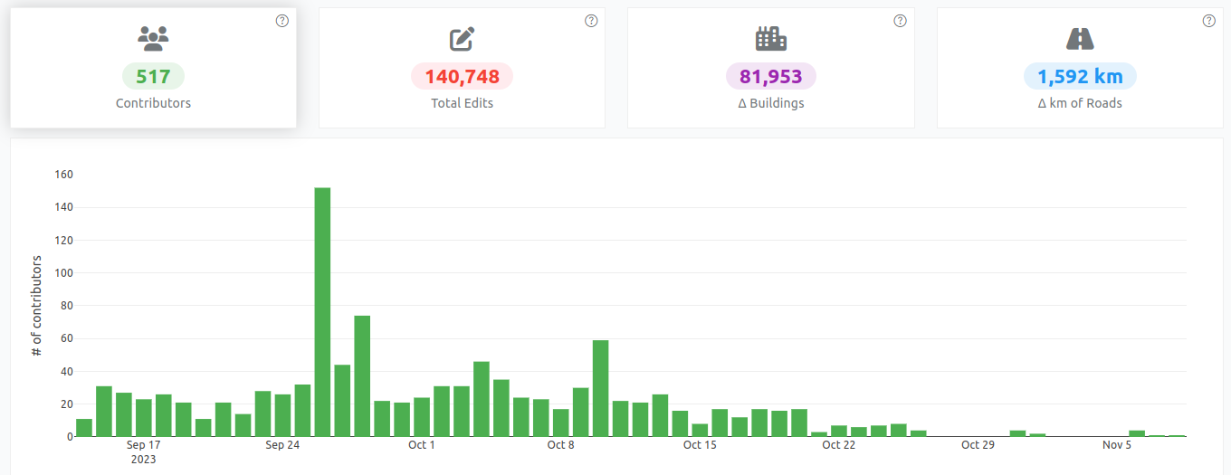
Posted by pedrito1414 on 6 December 2023 in English.
Activation info:
Activation: Libya Floods 2023
Activation Declared: Sep 14, 2023
Activation Concluded: Nov 9, 2023
Debrief Conducted by: Pete Masters, HOT, Activation Lead
Relevant statistics