لولب ام اخويط
Users' Diaries
Recent diary entries
Lấy vị trí khu công nghiệp Tân tạo
Video showing the easiness of streetcomplete
Link to the original message in mastodon.social
Short video showing the easiness of using https://www.openstreetmap.org/user/streetcomplete to improve OpenStreetMap and all projects which rely on it e.g. #cyclosm
Link to a Peer2Tube video on urbanists.video
Feel free to spread the video to promote Streetcomplete use!
Introduction
Many paths, tracks and even small streets are missing from OSM. And yet, these paths are often used by Strava users, who upload their traces there. So I thought it would be interesting to use these data to improve OSM.
That’s why I wrote a Python program which, by analyzing Strava data, is able to detect missing paths in OSM, then generate files to create MapRoulette challenges so that each missing path can be added to OSM.
What is Strava?
According to Wikipedia, Strava is a website and mobile application used to record sports activities via GPS. Its members use devices such as a GPS watch or smartphone to record their running activities, and send these to Strava. Currently (2023), there are over 100 million members.
Strava heat maps
On its website, Strava publishes a heat map showing the aggregation of all its users’ tracks.
Example:
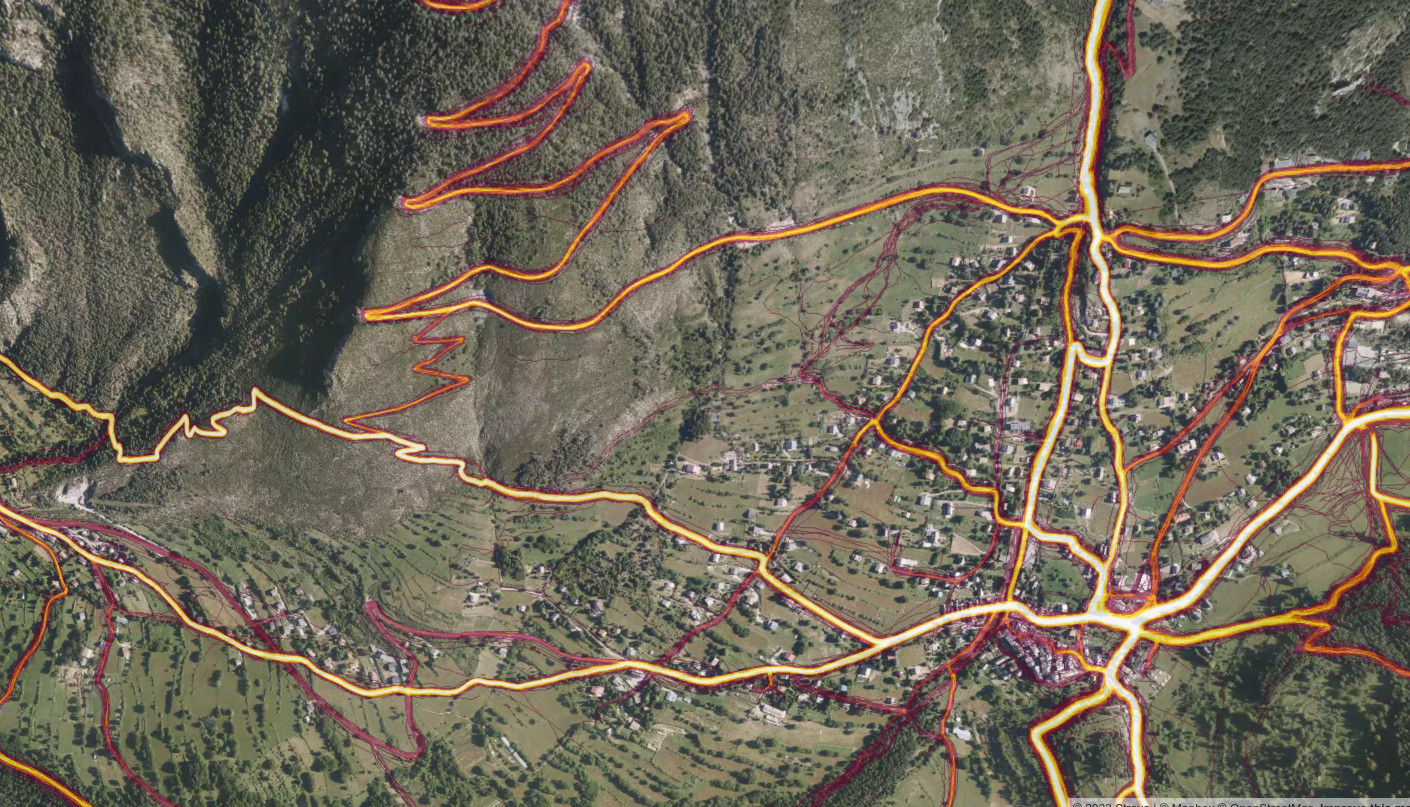
The more a route is ridden, the brighter its track appears on the heatmap.
Posted by Eden Oluigbo on 5 December 2023 in English.
Last updated on 10 December 2023.
👋🏼 Hello and welcome to my blog space where I share everything about my journey with Outreachy, HOTOSM and more. Thank you for joining me on this exciting journey! I am very excited to be part of the Outreachy program and If you’re interested in knowing the rest of my story, which I am willing to share it all :), please subscribe to my posts, so you get notified every time I publish a blog on my journey. Just like everything that ever existed, there’s always a beginning. So let’s zoom🔍 out a little bit to where it all began 😊.

Introduction
My name is Eden Oluigbo. I am a full-stack developer, artist and creator living in Abuja, Nigeria. I'm an open-source advocate and love contributing to the improvement of open source software. I started an active contribution to open-source projects in 2022. I joined different communities, made contributions and got PR merges (that excitement of having your PR merged never gets old haha😁).
Why Outreachy?

This is a cross post from the HOTOSM blog.
As Community Strategist and Research Lead at HOT, I would like to take a closer look with you all at the evolving landscape of OpenStreetMap (OSM) contributors, especially in the context of local knowledge and its crucial role in our mapping efforts.
Summary
Our recent study reveals a trend in local knowledge contributions in OpenStreetMap: a small but dedicated number of local mappers, making up just about 3% of contributors who are in the area mapping, is responsible for approximately 75% of the detailed mapping contributions.
This significant finding underscores the vital role of local knowledge and expertise in creating comprehensive and accurate maps, especially in humanitarian and unmapped/under-mapped regions. Despite a general decline in new OSM contributors, the impact of this core group of local mappers remains profound and indispensable for the future of the project.
We would like to engage researchers and mapping communities to unveil what are the implications of these numbers and the opportunities to use them to better support mappers.
The Spark of Inquiry: Simon Poole’s Analysis
Our journey began with Simon Poole’s important observation: a 20% drop in new OSM contributors. This sparked intense discussions within our team and motivated us to investigate further, particularly focusing on regions where HOT is actively involved.

eryrey

Another year, another Pista ng Mapa 2023 in Tacloban City!
Hosted by UP Visayas Tacloban YouthMappers, it’s a gathering celebrating open mapping, data, and an unforgettable journey. I am grateful to the organizing team for the scholarship grant and the chance to present. Thank you, UP Tacloban Youthmappers, for the warm welcome and for keeping our surroundings pristine.
The conference was a three-day journey packed with eye-opening lightning talks. From Leanne Caye D. Obispo’s “Data: A Story to Tell” to Sir Denrazir Atara’s spatial analysis of tree species, each session was a revelation. Erika Del Rosario Pauline Jen Madrona’s drone training and Oriel Jay Ibañez’s insights on community development through drone imaging were inspiring. Sir Ben Hur Pintor’s discourse on data management and Ms. Dinnah Feye Andal’s introduction to Mapillary were eye-openers. And oh, the endless field trip—such a blast! where I can say I shall return to Tacloban
Meeting old friends, making new ones on social nights, connecting with mentors again like Sir Mikko Tamura, Ms. Feye Andal, Leigh Lunas, Sir Ben Hur, and Sir Aimon, and connecting with the local YouthMappers chapters were a highlight! This was my 2nd Pista ng Mapa 2023, a great adventure with a small team with Dora (Me), yet the knowledge gained, networks built, and friendships forged were beyond measure. Here’s to hoping next year brings even more from our chapter.
I look forward to creating new memories and deepening my mapping passion at the next Pista ng Mapa (also SotM, manifesting!). Huge thanks to everyone who made this event an unforgettable experience!

Thank you

Asante sana
Your participation in 2023 GIS Day Conference was hugely appreciated
"Geospatial technology stands as a cornerstone for fostering a robust digital economy in Tanzania,serving as a catalyst for achieving sustainable development that will secure a prosperous future for forthcoming"
Dr. Moses Nkundwe Mwasaga, DG ICT Commission
Throughout the conference, we witnessed over 200+ participants gathered at the Tanzania Commission for Science and Technology (COSTECH) in Dar es Salaam to exchange knowledge and participate in dialogue on utilising geospatial technology for sustainable development in Tanzania.
The conference brought together geospatial enthusiasts, leaders, and practitioners across industries, the private and public sector, academia, and civil society organizations to promote changes that can be made at the community, producer, and government levels for sustainable development.
Engaged participants included:
Posted by well33ru on 4 December 2023 in Russian (Русский).
Где находится: г. Владимир, на расстоянии 300 м к западу от пересечения ул. Мира и Октябрьского пр-та, 50 м к югу от ул. Мира.
Описание: Объект природы “Источник” – стабильный и концентрированный сброс подземных вод. Относится к группе вод нисходящего типа. Примерный расход равен 0,2 л/сек. Недавно источник был благоустроен. В процессе облагораживания было установлено в качестве каптажной камеры железобетонное кольцо. Оно выделяется на 0,8 м над поверхностью и защищено железной крышкой. Для защиты воды от загрязнений была установлена металлическая труба. Для стекания воды был поставлен на высоте 20 см от трубы специальный резервуар, под которым выложен на деревянный пол. Возле источника установлены 2 беседки – одна с четырехскатной крышей, покрытой металлочерепицей, вторая - с двускатной крышей и удобной скамьей для комфортного отдыха. Вода из источника образует небольшой ручей, который спускается вниз по склону. Доступы к источнику оборудованы широкой бетонной лестницей с улицы Мира, имеется грунтовая тропа, с последующим прохождением по деревянным мосткам. Для местных жителей прилегающих районов Владимира это место является источником питьевой воды.
Основной целью обустройство природного памятника является сохранение уникального гидрогеологического объекта, являющимся источником питьевой воды для горожан. Еще одним приоритетом проекта считается поддержание гидрологического режима территории.
Факторы, представляющие угрозу для родника на улице Мира
Idk wtf this shit is or why I’m on here trying to figure it out.. but hey, whatever!!!🙃🙃😻😻🤣🤣🤦🏻♀️🤦🏻♀️🌻😸👀

Une semaine calme sur OSM avec seulement quelques petits updates de micromapping vraiment. C’est toujours un objectif actuel, en tout cas pour certains coins de Seraing, mais le temps libre m’a fait un peu défaut et donc c’est tout ce que j’ai fait.
Au niveau des vidéos, j’ai également été un peu plus lent avec seulement deux nouvelles cette semaine :
Ce randonneur se balade sur le tracé du tram vicinal 713 à Seraing et part sur une tangente - Deuxième partie de la randonnée du 19 novembre où je me balade sur un ancien tracé de tram vicinal… et m’énerve un peu à cause d’un trio de motards que je rencontre par trois fois ce jour-là
Ce cycliste part sur les traces de l’ancien tram vicinal 456 à Seraing (et Neupré un tout petit peu) - Une “vieille” vidéo ici (elle date d’avril 2023) où je prends le même tracé en VTT (et en entier) jusqu’au “finish” devant une barrière à Neupré. Je mentionne cette vidéo ici vu que ça a aussi un rapport avec la dernière qui est…
Ce mappeur OpenStreetMap fait un débriefing de sa dernière vidéo et explique sa logique pour mapper - Le contenu est dans le titre, mais j’explique pourquoi j’ai mappé une partie du vicinal 713 d’une certaine manière sur OSM, ce que je ferais si je me décidais à faire le Bois de la Neuville un jour, et aussi pourquoi j’ai mappé un chemin à Rotheux différemment que le tronçon du 713 malgré une situation similaire. Je m’attends à quelques critiques ici pour être honnête, mais je voulais un peu exposer ma logique dans cette vidéo
Une semaine un peu plus light donc. Il reste deux vidéos “live” de cette randonnée qui devraient être plus simples à éditer, et la semaine qui vient semble plus calme donc je devrais reprendre un peu plus mon micromapping sur OSM.
A+
مضخة بالغنية
شركة سلوق الخير للابقار
Posted by مراجع محمد الفاخري on 2 December 2023 in Arabic (العربية).
اديار عيت بوالدروقي
منطقة ظهر بوحميدة
حكفة عيت بوالدروقي الجدارية
بئر العمية
دفة الشاعر
مقطوعة اقويطين الخلفية