
What’s this for?
Users' Diaries
Recent diary entries
~~~This blog is also posted on my Medium account here ~~~
We often talk about how OpenStreetMap contributes to various initiatives like disaster responses, urban planning, land use analysis, and research. However, I believe we’re not doing justice to OSM by not sharing how it has profoundly impacted our personal lives. As OSM celebrates its 19th birthday, I’d like to offer my story as a birthday gift — a glimpse into how OSM has transformed me. I hope you find my journey an enjoyable read!
I became a part of OSM in 2015, just a few days after completing my final university examination. To be honest, I joined because I found myself with time on my hands, waiting to secure a job opportunity. Little did I know that this decision would mark the beginning of a transformative journey.
I got introduced to OSM by Geoffrey Kateregga, when the Ramani Huria, (Swahili for Open Map) a HOT-led project was kicking off in Tanzania. The project involved over 150 students & fresh graduates from the University of Dar es Salaam and Ardhi University to map flood-prone areas of Dar es Salaam, and this is where OSM started transforming me!
I made my first map edit at the campus ground, and it sounds trivial but I was super excited after Geoffrey mentioned that, anyone in the entire world can be able to see what I mapped, validate and actually use that! Honestly, it’s that thrill that keeps me engaged with OSM even today — yes, it’s that powerful! haha.
I’m lucky sometimes to find something just like this. Uhhh. It was tough. https://osmcha.org/changesets/139739372
before

Posted by LySioS on 10 August 2023 in French (Français).
Last updated on 17 August 2023.
Intro
J’ai découvert il y a quelques jours l’initiative de la commune de Pontevedra, en Espagne, d’implanter sur son territoire des cartes de temps de déplacement à pied entre les différentes zones d’intérêt de la commune. Cette initiative date de 2011 et s’inspire du graphisme schématique des plans de métro.
Cela s’appelle un metrominuto.
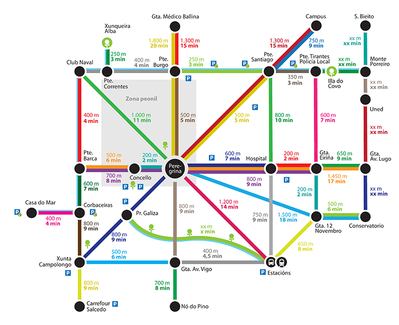
le metrominuto originel, source: https://metrominuto.info/
L’intérêt est de valoriser un autre mode de déplacement que la voiture en affichant le temps réel de parcours à pied entre 2 endroits de la ville, ces derniers étant souvent surestimés.
Cela permet, en additionnant les différentes valeurs temps des segments empruntés d’avoir une idée approximative de son temps de trajet.
Depuis, ce projet a fait des émules. Quand on recherche metrominuto sur internet, la plupart des plans qui ressortent sont espagnols. En France, on peut citer la ville de Toulouse et tout récemment, Saint-Brieuc.
Types
On the 9th of August 2023, I participated in the State of the Map Africa scholarship committee in reviewing the application submitted by members of OSM Africa for sponsorship to this year conference that to be held in Cameroun.
Posted by Piotr Strębski on 10 August 2023 in Polish (Polski).
Last updated on 15 August 2023.

 Projekt “OpenStreetMap dla zwierząt domowych” - mapowanie miejsc związanych ze zwierzętami domowymi: schroniska, gabinety i lecznice weterynarii, parki/wybiegi dla zwierząt, krematoria, cmentarze… Pamiętamy także o państwowej inspekcji weterynaryjnej i Towarzystwie Opieki nad Zwierzętami!
Schronisko dla zwierząt
(oznaczenie na mapie - obowiązkowo) amenity=animal_shelter
(dla jakich zwierząt - opcjonalnie) animal_shelter=*
(nazwa miejsca, jeśli istnieje - opcjonalnie) name=*
(godziny otwarcia - opcjonalnie) opening_hours=*
(numer telefonu - opcjonalnie) phone=*
(adres e-mail - opcjonalnie) email=*
(strona internetowa - opcjonalnie) website=*
Gabinet/Lecznica/Klinika/Szpital weterynaryjny
(oznaczenie na mapie - obowiązkowo) amenity=veterinary
(dla jakich zwierząt - opcjonalnie) pet=* (zobacz: pet=*)
(nazwa miejsca, jeśli istnieje - opcjonalnie) name=*
(godziny otwarcia - opcjonalnie) opening_hours=*
(numer telefonu - opcjonalnie) phone=*
I thoroughly enjoyed my involvement with the FMTM testing team, where I gained invaluable experience in data collection within Shyira Sector, Nyabihu District, located in the picturesque western province of Rwanda. Working alongside a remarkable team from Rwanda, I was inspired by the diverse and enthusiastic individuals I had the pleasure of collaborating with. The Rwandan terrain, delectable cuisine, and engaging interactions with members of the HOT community left an indelible mark on my memory.

Create, Cultivate & Thrive: Are We Doing Enough?
Resilience is the ability of a community to continue to live, function, develop and thrive after a crisis. Key elements of enhancing resilience include maximizing social cohesion, collaboration, empowerment, participation and consideration of local characteristics and issues. This means dialogue within, and inputs from, the community itself. Skilled volunteers within the community are then to take the responsibility to rebuild relationships — within the community, with the external stakeholder i.e. organizations, and governments, to revive the buzz again and again, where it was left behind. These relationships form a solid foundation on which other community volunteers can create positive change, by improving their skills and abilities for better contribution. Fresh thinking is also needed more than ever because volunteers have unique attributes that make them essential and put them at the heart of the restoration process.
Like most community-based resilience volunteering, volunteering with the OpenStreetMap community is also uniquely flexible. People from all backgrounds sign up to support a wide range of initiatives, activities & organizational efforts across social, economic, health, logistics, environmental development & humanitarian crisis response by enriching open & sharable geo-data repository through the OpenStreetMap platform. We know from experience that it works as a great support in every context and adds value to every type of program, from Disaster risk reduction & response, public health, protection, wash, education, information management & logistic support, by fueling evidence-based interventions. The approach is universal and adaptable nowadays; community capacity development, operation & program management, mentoring & leadership are the key components to strengthening & sustaining activism.
After giving the “How to become an OSM pro” talk at CCC last year, I will give two talks at CCCamp23 next week:
Introduction to OpenStreetMap
This covers what OSM is (not), why to map, where to map, what to map, and how to map. Perfect to get your friends started with OSM!
Querying OpenStreetMap with Overpass-Turbo (cancelled)
Introduction and examples of using the [Overpass Query Language](osm.wiki/Overpass_API/Overpass_QL) and [Overpass-Turbo](https://overpass-turbo.eu/) to fetch data from the OpenStreetMap database. Can be used for mapping, quality assurance, or research
Edit: There is an Overpass talk at CCCamp already, so I’ll do mine some other time.
⚠️ The talks will not be recorded
The exact time is not yet announced, keep an eye on the (self-organized) schedule, or follow me https://www.openstreetmap.org/user/[email protected] on Mastodon. See you at the camp!
Posted by raphaelmirc on 9 August 2023 in Brazilian Portuguese (Português do Brasil).
9 August
In 2023 the project birthday, the OpenStreetMap 19th Anniversary Birthday party will be celebrated on or around 9th August 2023 in cities all around the world!
OSM 19th Birthday Celebration by UmbraOSM. An online meet-up to map, talk about OSM and drink. It is planned to map the building of a suburb of São José dos Pinhais, PR, called Quississana. Join us on Meet Jitsi, starting at 20:00, GMT-3, São Paulo Time Zone. Join us also on Telegram
Posted by umbraosmbr on 9 August 2023 in English.
OpenStreetMap 19th Birthday Party
In 2023, the project’s anniversary, OpenStreetMap’s 19th anniversary birthday party will be celebrated around August 9, 2023 in cities all over the world! osm.wiki/OpenStreetMap_19th_Anniversary_Birthday_party

PROJECT LINK:
https://tasks.hotosm.org/projects/15381/
The Openstreetmap 19th birthday party event will take place today at 8:00 pm with the Quississana neighborhood map, in the city of São José dos Pinhais, Paraná relation/1123929#map=15/ -25.5504/-49.1532 where we will map the buildings that are missing in the neighborhood and we will also promote an online meeting of Brazilian mappers in the room of UMBRAOSM - Union of Brazilian Openstreetmap mappers at the link: https://meet.jit.si/ umbraosm
The Event will be promoted by UMBRAOSM - Union of Brazilian Openstreetmap Mappers
Festa de aniversário de 19 anos do OpenStreetMap.

Tak jsem si dovolil dodat pár záznamů do mapy v místech, kde se pohybuji. Jde především o detaily, které nejsou uváděny ani v komerčních mapách (koše, lampy, soukromé a příjezdové cestičky), které ale mohou být užitečné třeba ke geo-cachingu, nebo k přesnější orientaci v místě. Pomalu se učím za chodu.
Posted by UndueMarmot on 8 August 2023 in English.

One of the biggest things that’s annoyed me with OpenStreetMap is the pertinent lack of POIs, compared to the big G that many around me have generally accepted as the standard navigation app and database for everyday use. It actually made me excited for Overture Maps, as I thought we could easily take the good stuff from Facebook’s places data to improve our map.
When the Overture Maps Foundation’s data released its first alpha files, naturally, the OSM community started sleuthing in there. The job became even easier when community member @bdon released a tool to overlay the POI dataset into an OSM basemap, as seen here.
The way Meta sourced the POIs in the first place has unintended consequences, however, like…
Top 12 Beach Resorts inside Neighborhoods near Me
That heading would suffice for a top-ten listicle, haha.
I’ve manually listed a small sample of such hotels, resorts and other kinds of supposed accommodations that, for humans, “obviously don’t belong there”: first as screenshots one-by-one, and then add them all into a table.
1 — Water Park in Tract Housing
I asked my first question on the Support Forum. Member Minh Nguyễn was kind to answer it quickly and accurately. I wanted to add a speed limit to a Way but the Way was under a “Boundary” data label.. The solution: Select Edit.. Then on the RIGHT side of map area are icons. By selecting the one called “Map Data” and then clicking on heading called “MAP FEATURES” and then un-checking the box for “Boundaries” then the Map doesn’t display “Boundary Data” With that layer now hidden the WAY was easy to select and add Speed Limit Tags. The OSM ID Editor has many cool features once someone shows me.. :)
Tonight I learned how to designate different Speed Limits on the same road going in different directions. The Forward direction of a “Way” has little guide triangle icons when a Way is selected that act like arrows. These triangle icons point in the Forward Direction. The reverse of Forward is Backward. After selecting a Way, there is a menu on left called TAG’s. I simply press add (+) to create a TAG called maxspeed:forward and maxspeed:backward and assign a speed limit appropriate for that section of Way. It doesn’t populate “mph” so I needed to remember to include that after the speed. I figured that out later and went back and double checked all my Forward and Backward speeds. I like best when a street has the same speed limit in both directions. However many primary streets have sections with different speed limit overlap. ID editor really has some cool features. :)
Случайно проскочила ссылка на канале ОСМ в телеге на классную статью про StreetComplete.
https://telegra.ph/Prodvinutyj-StreetComplete-08-05
К сожалению не знаю кто автор и где можно посмотреть список на остальные статьи.
UPD: Похоже автор TrickyFoxy, вот его пост: @TrickyFoxy/diary/402091
Не обратил внимание на ссылку в левом верхнем углу.
ИМХО лучше было бы размещать такие статьи в блогах на ОСМ: osm.org/diary
https://telegra.ph все таки проприетарная площадка. И найти контент там значительно сложней.


Before I started mapping I didn’t think much about walkability. There are parts of the city that are hard to get to without a car.
Some streets don’t even have a sidewalk. Theres a chance that curbs have no ramp for wheelchair users. I will say though that the city is making things better.
A couple new walking paths were built along the two main roads. Near my house there was also work done to the roads and sidewalks. We now have ramps on the curbs!
5/8/2023: Salí de vacaciones a la playa de Cayo Bariay, aproveché la ocasión para mapear la zona. Pude recolectar datos de las instalaciones de la playa, las calles y los poblados por donde tuve que viajar. Me sorprende mucho como hubieron una cantidad de edificios como bodegas y clínicas que no habían sido indicados anteriormente en OSM, por lo tanto también me sorprende la poca colaboración de esta zona. Los datos recopilados lo iré añadiendo poco a poco.

Cool