Posted by Gustavo22Soares on 31 August 2022 in Portuguese (Português).
Users' Diaries
Recent diary entries

Posted by Socredelir on 31 August 2022 in English.
Last updated on 1 September 2022.
More than 5 mysterious building sites were found in Kissidougou district, Guinea, where the satellite maps show only forest.
These sites were crowded each with more than 30 buildings, each are squares with size about 100x30 m. It is very clear to be seen when we take a look at the OpenTopomap in the north and the east of Kissidougou city, where these buildings are rendered as a lot of big black spots.
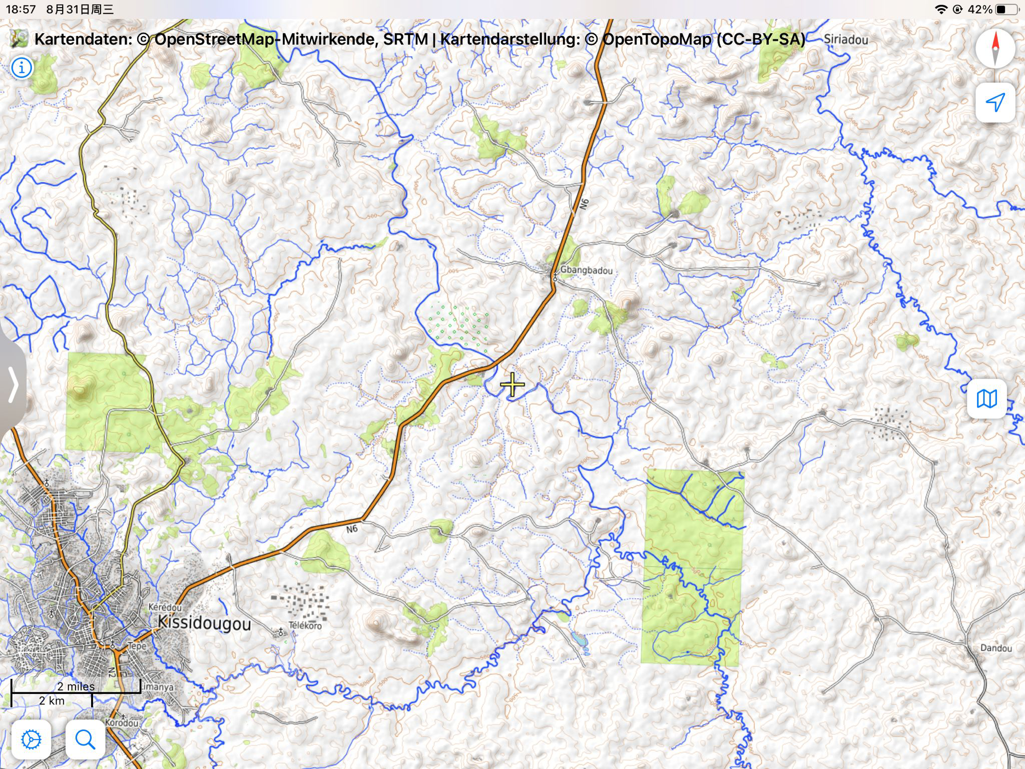
The position marked in the article is only one typical example among them: osm.org/#map=15/9.2019/-10.0495
Posted by radiotrefoil on 31 August 2022 in English.
Last updated on 9 March 2024.

Introduction
Taking open-source street-level imagery is a productive and fulfilling way to make a lasting contribution to OpenStreetMap. Typically, amateur street-level imagery uploaded to platforms such as Mapillary and Kartaview consists mainly of images scraped from dashcam footage, or from a handheld smartphone. To a lesser degree, some 360 imagery is also taken. Whilst these are valuable, many street-level imagery sequences suffer from various drawbacks including poor resolution and spatial accuracy, motion blur and narrow field of view. Generally the imagery compares poorly to proprietary alternatives that cannot be used for OSM. In this post I propose a fairly low-budget option for 360 street level imagery that has led to satisfying results. The results are comparible to roughly 1st-2nd generation Google Streetview (circa 2010) and is far better than TomTom/Bing Streetside imagery in Australia.
In this post, GPS refers to geopositioning in general through GNSS, rather than the US satellite constellation.
This post is written from Australian perspective using Android/Windows, so results may vary.
By “affordable” I mean <$1000 AUD. My total expenditure on this project was $700-800 AUD, so that may be inaccessible to some.
I am likely to update this post in the near future as the project continues. Please check back here regularly if you are interested, and feel free to reach out on OSM or the OSM World Discord server.
Camera selection
Posted by Adedewe Abiodun on 31 August 2022 in English.

On this day, I participated in Unique Mappers OSM Nigeria, a monthly Mapathon. It was so exciting to have everyone joining from different part of Nigeria and beyound. I look forward in few weeks ahead when Etsako east would be completely mapped to provide open map and data for humanitarian use.
Today I participated in Unique Mappers OSM Nigeria monthly Mapathon during which I facilitated the mapathon and providing training to newbies in the beginners room. It was so exciting to have everyone joining from diffrerent parts of Nigeria and beyond ,including Germany and Tanzania. We look look forward in the few weeks ahead Etsako east project would be completely mapped to provide open map data to drive humanitarian response and social good project
Posted by HungarianVoyager on 31 August 2022 in Hungarian (Magyar).

Az utóbbi időben észrevettem, hogy egyes helyen az épületek a műholdképek eredeti helyzetétől eltova kerültek felrajzolásra. Fel kellene mérni, hogy melyik eltolás vázolja fel pontosan a valóságot, vagy hogy a valóságban van-e egyáltalán eltolás a műholdképek eredeti helyzetéhez képest. (Lásd: Siklósi vár, várfal.) Azért lenne nagy szükség erre, hogy Siklós ne egy nagy összevisszaság legyen a térképen.
Várom a javaslatokat, hogyan lehetne ezeket teljesíteni. Én a GPX nyomvonalakra gondoltam egyrészt, vagy egy LIDAR-os drónra, amivel fel tudnánk digitalizálni a terepet. LIDAR-os drónom viszont sajnos nincs.
- GPX fájl az eltolódás vizsgálatára: @Guzsv%C3%A1ny%20M%C3%A1t%C3%A9/traces/4849552
Posted by j-wills on 30 August 2022 in Russian (Русский).
Last updated on 31 August 2022.
Переосмысление пришло после нескольких лет активного участия в маппинге. Я регулярно находил время между работой и семьёй на прогулки по району с целью уточнения данных. Одно дело новую тропинку отрисовать, исправить неточность. Где-то добавить POI, где-то внести время работы, контакты и прочее. С крупными магазинами проблем возникало меньше, так как тот же Перекрёсток если открывается, то открывается надолго и в его работе мало что меняется годами. Самая основная головная боль - поддержка в актуальном виде мини-магазинчиков. Сегодня тут пиво, завтра шаурма, послезавтра восточные сладости. Одно дело, когда всё это у тебя перед глазами, на пути от метро до дома, к примеру. Другое - когда на другом конце микрорайона, где ты бываешь раз в год в лучшем случае. Этот недостаток можно было бы решить привлечением новых маперов в проект, но, к сожалению, в России OSM непопулярен, а количество энтузиастов, готовых за бесплатно тратить несколько часов, а то и дней в неделю своего времени на маппинг стремится к нулю. В этом плане, конечно, респект и уважуха literan !
На фоне всего происходящего в OSM, Яндекс карты просто вне конкуренции, особенно с их подходом к рекламе на карте. Владельцы торговых точек (к примеру) сами их вносят и следят за актуальностью информации.
Так что в OSM есть смысл вносить лишь те POI, которые ни куда не уйдут или же, которые вы часто видите, иначе через несколько лет получите тонну мусора на карте, к сожалению.
Posted by kwiatek_123 on 30 August 2022 in Polish (Polski).

Wstęp
Mój pierwszy projekt - szczegółowe zmapowanie obszaru mieszczącego się między ulicą Józefa Chłopickiego, Makowską i Szaserów. Był to też projekt, który nauczył mnie całego OSM’a. Zbyt dużo nie ma co tutaj opisywać, ale postaram się wypisać najważniejsze etapy tworzenia oraz powstawiać gify 😁
Mapowanie
Na początku zaplanowałem, w jaki sposób będę mapował, żeby przelecieć po wszystkim. Trudne to nie było, bo przecież obszar jest mały i podzielony drogami. Zacząłem mapować od lewej do prawej i od dołu do góry, gdzie jeden changeset obejmował “wyspę” otoczoną drogami, których nazwy zawarłem w tytule zestawu zmian. Dodawałem płoty, ogrody, ścieżki, podjazdy, wejścia do domów. Gdy doszedłem do ulicy Lubieszowskiej @syntex zwrócił mi uwagę, że landusy nie są pocięte oraz, że budynki nie są wymienione. Wytłumaczył mi co i jak i musiałem od nowa przelecieć po wszystkim. (No ale tak to jest, że pierwsze edycje są gorsze od nowszych).
Posted by HungarianVoyager on 29 August 2022 in Hungarian (Magyar).
Ma az unokatestvéremmel, úgy döntöttünk, hogy elmegyünk biciklizni. A kellemeset a hasznossal keverve, felvittem a házszámokat a Korvin utcában Siklóson, valamint a Gyűdi úton, s a Járó Péter utca jobb oldalán, Máriagyűdön.
Posted by JanetChapman on 28 August 2022 in English.

It was wonderful, if slightly overwhelming and sometimes surreal to finally meet so many fellow mappers again at SOTM Firenze last week, as well as so many new friends that I’d only interacted with online. This was my 4th in person event and it reinforced not only how much Crowd2Map has grown since Brussels 2016 but also how the mapping community has changed.
In 2016 arrived in Brussels late at night, a bit disconcerted to find that I was sharing a bed with a stranger - Miriam from GeoChicas. We quickly got over this surprise and she became a great friend and ally, even visiting the FGM Safe Houses we work with in Tanzania en route to FOSS4G 2018. In Brussels I was a newcomer who knew no one. I tried to navigate the seeming chasm between the brown shirted craft mapper gang and the humanitarian team. In Firenze I was very pleased to note much less of this divide. Arriving felt like coming home after a long journey, meeting so many people from previous events and others for the first time IRL.
Particular highlights for me were talking about the impact of our Digital Champion project, meeting colleagues from Missing Maps HOT and Youthmappers who I’d only interacted with online. Kristen Tonga’s talk on the challenges of mobile mapping in rural Tanzania really resonated with our experiences setting up our Digital Champions program, and we look forwards to working with her going forwards.
Ilya is always enthusiastically working on something interesting and this year was no exception, we’re looking forwards to working with him on Every Door soon. The We’re also looking forward
We were particular proud that Binyam Dele Youthmapper Ambassador from Ethiopia wants to replicate our work fighting FGM there.
Greatly looking forward to next meet up - particularly State of the Map Tanzania in January 2023 and hope to see many of the mapping community there either in person or online!
Posted by radiotrefoil on 28 August 2022 in English.
Last updated on 26 June 2025.
The following is an incomplete list of 360 camera sequence examples by model on Mapillary, along with some comments, with respect to the image quality and price of the camera. This will be an ongoing work in progress.
| Camera | Example | Comments |
|---|---|---|
| GoPro Fusion | Radiotrefoil | Image clarity much worse near stitch line between hemispheres but overall quite good |
| GoPro Max | 360ms; ademturkmen | Very similar performance to Fusion |
| NCTECH LTD iSTAR Pulsar | zaf3kala | Professional quality 11K spherical images, price unknown but assumed to be very high |
| LG Electronics LG-R105 | yoelt | Cheap option, offers OK results but a lot of text illegibile |
| HUAWEI VOG-L29 | lehestener | Invalid spherical image? |
| Insta360 One X2 | jkingsleya | Image quality doesn’t justify price of camera |
| Ricoh Theta SC | adam2 | |
| MADV/Xiaomi Madventure | gness | |
| Garmin VIRB 360 | max93600 |
Please feel free to help me add to this list and share your insights using the Google sheets link below. https://docs.google.com/spreadsheets/d/1ajTm_0fRKLHiGJS2TW0CNscbW4NItuyjkJxzU_kbLXg/edit?usp=sharing
The Mapillary GraphQL API can access metadata for camera make/model, however it is an undocumented feature and lately I have been getting “access denied” error even when using my API token. If anyone knows a workaround please comment.
Some times I feel like I’m the only person who really gets me. I don’t have friends, but a mother that is our of this world. I want to explore this
I was preparing a video tutorial about stiles (online tomorrow morning on my channel). Even though I have mapped quite a few stiles while hiking, I came to the realization that I had mapped a lot of them wrong (mostly using OSMAnd, where I have to remember a lot of tags, bc they’re not presets) after reading the wiki page barrier=stile. Oops. While reading the page, it occurred to me that it was a bit messy, so I tried to tidy it up a bit and tried to find some examples for such cases that are a bit tricky to decide, like the stepover. I had tagged some of those as ladder, because they included more than one step.
I also took a look at the taginfo for the stile values, and boy, was there chaos! I mean, we’re mostly all humans, so we make mistakes and typos which might then be propagated through auto-text in JOSM or copying and pasting, who knows. I actually found one mistake I made myself this way. Some were obvious typos (steover) that I could correct without having visited the site, for others, I contacted the person who had added them (sometimes as far back as 8 years ago, so they couldn’t remember, and just had to delete the stile=* line, unfortunately).
But I also looked at commonly used ones like hipster and added explanations to the wiki page. Two I had to translate into English, and I hope I did it correctly, because they were both in languages I don’t speak, so I used image search to figure out what could be meant. I reduced the list from 4 pages of values to 2.5, so it’s a bit tidier now.
کنسول/میز تیوی/جلومبلی/عسلی/جا کفشی /با بهترین کیفیت در ابعاد و رنگ دلخواه قابل سفارش میباشد
Posted by BG2ETV on 26 August 2022 in Chinese (China) (中文(中国大陆)).
Last updated on 27 June 2023.

跟一下西园寺铃老师的风)
——————
>工程进度查询<
预处理阶段 线路代码与相关信息替换,添加车站TMIS
按照GB T 25344-2010执行
第一阶段 局直站、主要编组站、各机车、车辆、工务相关单位
哈尔滨 齐齐哈尔 牡丹江 佳木斯 三间房 哈尔滨南 东佳木斯 昂昂溪 富拉尔基 等
哈尔滨机务段 三棵树机务段 齐齐哈尔机务段 牡丹江机务段 佳木斯机务段及下属车间;
三棵树车辆段 齐齐哈尔北车辆段 齐齐哈尔车辆段 齐齐哈尔车辆厂及下属车间;
哈尔滨大机段 牡丹江救援车间及下属基地;
第二阶段 各线路的分界站交汇站、枢纽站旁以信号所或线路所形式设立的车站
绥化 南岔 莲江口 东门 香坊 孙家 王岗 万乐 朝中 加格达奇 林口 勃利 等
第三阶段 局界口、国界口、换轨站
兰棱-蔡家沟 五常-杜家 立志-太阳升 泰来-街基 斗沟子-鹿道 阿尔山北-伊尔炧-阿尔山 绥芬河 满洲里 同江北
第四阶段 各线沿线车站线路整修、分析线路拨改废弃痕迹、增加道岔股道编号、校准正线站线分布与里程数据
已于2023-06-27完成基本工作。
第五阶段 线路打包、建立关系
该步骤正在北京局试点,本工程已作前期预留,待体系成熟后将会同步。

I’m sure some of you have heard of a map that shows the locations of AEDs in Poland, available at https://aed.openstreetmap.org.pl. Thanks to community activism and a campaign among local government units, more than 3,000 device locations have been introduced. Encouraged by the success of the Polish map, we were then tempted to expand the project’s area of operation to increase community involvement in inputting AED device data into the OpenStreetMap database.
Currently, two members of the OSMP organisation tomczk and starsep are attempting to rewrite the existing version of the website using React technology and implement new functionalities. Their results to date are now available at https://openaedmap.org.
The website will be continuously developing. We would like to prepare websites with statistics broken down by country and make it possible to download data in the same way as in the Polish version of the website. The Colleagues are also working on improving and extending the form to allow not only the addition of device data from the page, but also editing.
Our dream is to expand the functionality with the ability to add photos of devices in order to verify them and make it easier to find them in the field. For which we do not have the technical resources at the moment, but hopefully we can acquire a technology partner to help us with this.
Unfortunately, due to the amount of work this project requires, we need Your help. If you have skills in the following areas please email us at: aed@openstreetmap.pl
We need volunteers to support us with their React.js (front-end) and Python scripting skills, and because of the international character of the project we also need help with translations into languages other than English, with priority for French, Ukrainian, German and Spanish.
The Polish version of this entry is available at: OSMP page
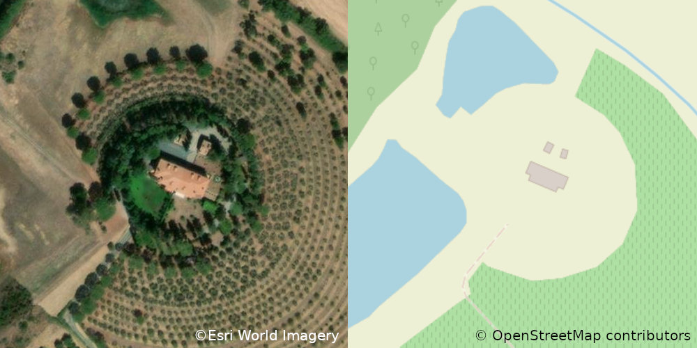
It’s not vandalism, but just a funny case of Pareidolia.
The location is near Castiglione della Pescaia, Tuscany, Italy.

At long last, I’ve done a complete pass over municipal and CDP
boundaries in New York State. Barring errors and omissions (I
daresay there must be some) every incorporated community and every
CDP in the state has had its border checked against NYSGIS
Civil Division Boundaries and TIGER/Line 2021 respectively, almost
always resolving conflicts in favour of the former.
All have place=* nodes representing them, with the node a label
member of the boundary relation.
Populations are updated as of the 2020 Census. GNIS, FIPS, NYS SWIS, Wikipedia and Wikidata links are provided.
Most of the remaining work that I’d have to do before I consider
the job to be done has to do with the tagging on the place=* nodes.
Right now, they’re a hodgepodge. Most of them came in from the TIGER
import of 2008 with place=* representing their form of government.
This is NOT an indication of the significance of the place.
Brentwood, Long Island, a bustling community of over 60,000 souls,
is tagged place=hamlet because it does not have home rule.
Geneva, a sleepy lakefront village is 3400 inhabitants or so,
is tagged place=city because it has a city charter.
For a first stratification, I’d propose simple thresholding on population:
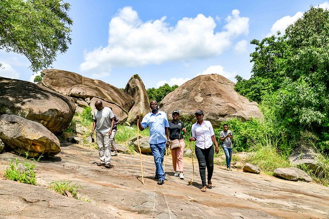 Baker’s Fort Patiko- Gulu District,Uganda
Ma hazafelé tartva felvittem StreetComplete-ből pár házszámot a Felszabadulás utcában. Utána, a Harkányi úton felvittem az épületek magasságát.