File:Wasserpumpewerneuchner.jpeg
Jump to navigation
Jump to search

Size of this preview: 450 × 600 pixels. Other resolutions: 180 × 240 pixels | 360 × 480 pixels | 576 × 768 pixels | 768 × 1,024 pixels | 1,536 × 2,048 pixels | 3,120 × 4,160 pixels.
Original file (3,120 × 4,160 pixels, file size: 4.62 MB, MIME type: image/jpeg)
This file and its description are from Wikimedia Commons.
Summary
| Description |
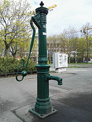
Deutsch: Wasserpumpe / Plumpe / der Notwasserbrunnen 24 (Nummernzuordnung nach Google Streetview-Ansicht. Das hier im Bild noch zu sehende H ist vermutlich Teil einer älteren Beschriftungsweise.) in der Werneuchener Straße in Berlin Althohenschönhausen, direkt am Straßenrand, nahe an der Ecke zur Genslerstraße. Die Blickrichtung ist vom Bordstein zur Genslerstraße. Der Blick geht über diese noch hinweg und dahinter ist das gerade im Bau befindliche Gebäude der Liebenwalder Straße 24 zu sehen.
|
| Date |
16 April 2016 (according to Exif data) |
| Source | Own work |
| Author | Z thomas |
| OpenStreetMap | Node 1141974530 |
| Object location | | View this and other nearby images on: OpenStreetMap |
|---|
| Camera location | | View this and other nearby images on: OpenStreetMap |
|---|
Licensing
I, the copyright holder of this work, hereby publish it under the following license:
This file is licensed under the Creative Commons Attribution-Share Alike 3.0 Unported license.
- You are free:
- to share – to copy, distribute and transmit the work
- to remix – to adapt the work
- Under the following conditions:
- attribution – You must give appropriate credit, provide a link to the license, and indicate if changes were made. You may do so in any reasonable manner, but not in any way that suggests the licensor endorses you or your use.
- share alike – If you remix, transform, or build upon the material, you must distribute your contributions under the same or compatible license as the original.
| This file was uploaded via Mobile Android App (Commons mobile app) 1.12. |
File history
Click on a date/time to view the file as it appeared at that time.
| Date/Time | Thumbnail | Dimensions | User | Comment | |
|---|---|---|---|---|---|
| current | 15:02, 16 April 2016 | | 3,120 × 4,160 (4.62 MB) | wikimediacommons>Z thomas | Uploaded using Android Commons app |
File usage
The following 2 pages use this file: