File:Regions and Prefectures of Japan.svg
Jump to navigation
Jump to search

Size of this PNG preview of this SVG file: 468 × 599 pixels. Other resolutions: 187 × 240 pixels | 375 × 480 pixels | 600 × 768 pixels | 800 × 1,024 pixels | 2,480 × 3,175 pixels.
Original file (SVG file, nominally 2,480 × 3,175 pixels, file size: 116 KB)
This file and its description are from Wikimedia Commons.
Summary
| Description |
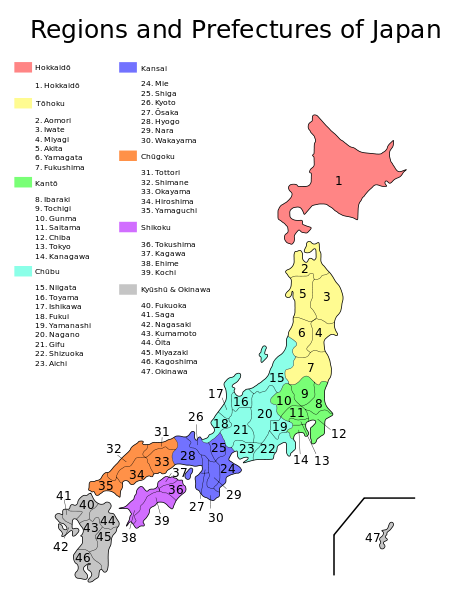
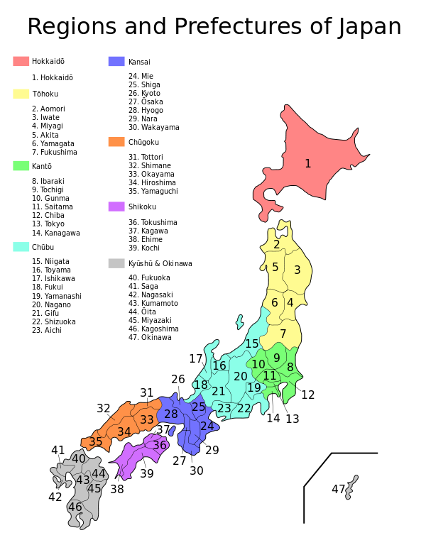
English: Map of the regions and prefectures of Japan in ISO 3166-2:JP order. |
| Date | |
| Source | Vectorized from Image:Regions and Prefectures of Japan.png. |
| Author | TheOtherJesse |
| Other versions |
Derivative works of this file:
File:Regions and Prefectures of Japan.svg contains 2 translations.
[]
|
| SVG development |


.svg)
.svg)
.svg)
.svg)


.svg)


.png)

.png)
.svg)

.svg)


Licensing
| I, the copyright holder of this work, release this work into the public domain. This applies worldwide. In some countries this may not be legally possible; if so: I grant anyone the right to use this work for any purpose, without any conditions, unless such conditions are required by law. |
File history
Click on a date/time to view the file as it appeared at that time.
| Date/Time | Thumbnail | Dimensions | User | Comment | |
|---|---|---|---|---|---|
| current | 07:36, 28 July 2024 | | 2,480 × 3,175 (116 KB) | wikimediacommons>Momiji-Penguin | File uploaded using svgtranslate tool (https://svgtranslate.toolforge.org/). Added translation for ja. |
File usage
The following page uses this file: