File:EnglandSouthEast.png
Jump to navigation
Jump to search
No higher resolution available.
EnglandSouthEast.png (200 × 247 pixels, file size: 11 KB, MIME type: image/png)
This file and its description are from Wikimedia Commons.
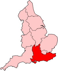
Locator map showing South East England

|
File:England Region - South East.svg is a vector version of this file. It should be used in place of this PNG file when not inferior.
File:EnglandSouthEast.png → File:England Region - South East.svg
For more information, see Help:SVG. |
 |

|
Permission is granted to copy, distribute and/or modify this document under the terms of the GNU Free Documentation License, Version 1.2 or any later version published by the Free Software Foundation; with no Invariant Sections, no Front-Cover Texts, and no Back-Cover Texts. A copy of the license is included in the section entitled GNU Free Documentation License. |
| This file is licensed under the Creative Commons Attribution-Share Alike 3.0 Unported license. | ||
| ||
| This licensing tag was added to this file as part of the GFDL licensing update. |
original by Keith Edkins on en:wiki
File history
Click on a date/time to view the file as it appeared at that time.
| Date/Time | Thumbnail | Dimensions | User | Comment | |
|---|---|---|---|---|---|
| current | 13:40, 8 June 2014 | | 200 × 247 (11 KB) | wikimediacommons>Mahahahaneapneap | Transparent background |
File usage
The following page uses this file: