File:Don Puay river bank landscape at sunset.jpg
Jump to navigation
Jump to search

Size of this preview: 800 × 450 pixels. Other resolutions: 320 × 180 pixels | 640 × 360 pixels | 1,024 × 576 pixels | 1,280 × 720 pixels | 2,560 × 1,440 pixels | 6,402 × 3,601 pixels.
Original file (6,402 × 3,601 pixels, file size: 4.44 MB, MIME type: image/jpeg)
This file and its description are from Wikimedia Commons.
Summary
| Description |
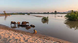
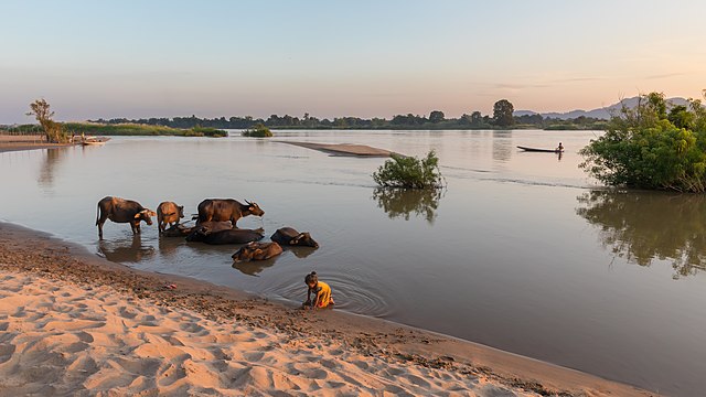
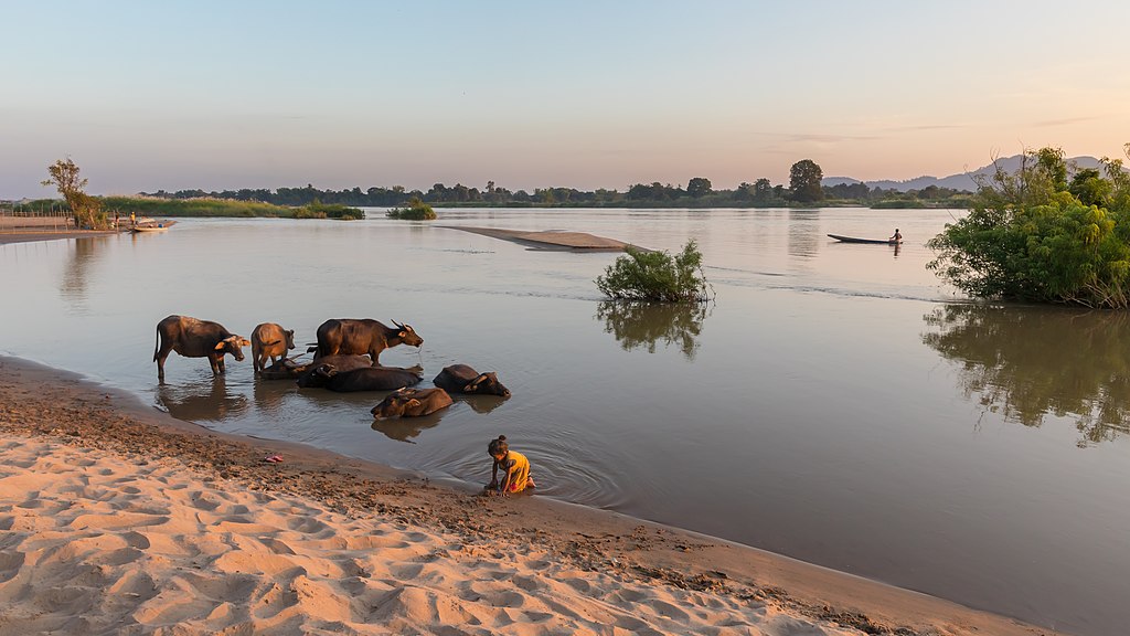
English: River bank at sunset from the island of Don Puay, Si Phan Don, Laos. Landscape with submerged shrubs reflecting in the Mekong, water buffaloes bathing, a young girl playing in the sand, and a fisherman on his pirogue at the distance
Français : Berge au coucher du soleil depuis l'île de Don Puay, Si Phan Don, Laos. Paysage avec des arbustes immergés se reflétant dans le Mékong, des buffles d'Asie se baignant, une fillette jouant dans le sable, et un pêcheur sur sa pirogue au loin
Deutsch: Flussufer bei Sonnenuntergang von der Insel Don Puay aus gesehen, Si Phan Don, Laos. Landschaft mit versunkenen Sträuchern, die sich im Mekong widerspiegeln, mit Wasserbüffeln beim Baden und einem jungen Mädchen, das im Sand spielt. In der Ferne erkennt man einen Fischer auf seiner Piroge.
Українська: Берег річки Меконг на заході сонця з острова Дон Пуай, архіпелаг Сі Фан Дон, Тямпасак, Лаос. Пейзаж із затопленими кущами, що відбиваються в річці, буйволи у воді, дівчина грається в піску, і рибалка на своїй пірозі вдалині.
Español: Orilla del río Mekong al atardecer desde la isla de Don Puay, Si Phan Don, Laos. Paisaje con arbustos sumergidos reflejados en el río, búfalos de agua bañándose, una niña jugando en la arena y un pescador en su piragua a lo lejos |
| Date | |
| Source | Own work |
| Author | Basile Morin |
| Other versions |
  |
| Camera location | | View this and other nearby images on: OpenStreetMap |
|---|
Assessment
|
This image was selected as picture of the day on Wikimedia Commons for 13 December 2022. It was captioned as follows: Other languages:
Čeština: Nábřeží řeky Mekong během západu slunce, snímek z ostrova Don Puay ze souostroví Si Phan Don v Laosu. Français : Des buffles d'Asie se baignant dans le Mékong depuis les berges d'une île de l'archipel de Si Phan Don (Laos). Українська: Берег річки Меконг на заході сонця з острова Дон Пуай, архіпелаг Сі Фан Дон, Тямпасак, Лаос. |
Licensing
I, the copyright holder of this work, hereby publish it under the following license:
This file is licensed under the Creative Commons Attribution-Share Alike 4.0 International license.
- You are free:
- to share – to copy, distribute and transmit the work
- to remix – to adapt the work
- Under the following conditions:
- attribution – You must give appropriate credit, provide a link to the license, and indicate if changes were made. You may do so in any reasonable manner, but not in any way that suggests the licensor endorses you or your use.
- share alike – If you remix, transform, or build upon the material, you must distribute your contributions under the same or compatible license as the original.
File history
Click on a date/time to view the file as it appeared at that time.
| Date/Time | Thumbnail | Dimensions | User | Comment | |
|---|---|---|---|---|---|
| current | 02:56, 16 February 2018 | | 6,402 × 3,601 (4.44 MB) | wikimediacommons>Basile Morin | User created page with UploadWizard |
File usage
The following 7 pages use this file: