treestryder's Comments
| Changeset | When | Comment |
|---|---|---|
| 52996367 | about 8 years ago | I have undone all of these changes, as they were mostly incorrect. Can I ask, what you were trying to achieve? Maybe, we could work together in the future. |
| 52969465 | about 8 years ago | I am slowly reversing all of your changes and am working on this changeset now. Log:
Next time, please review the OSM documentation, consult the Lansing Wiki page for area standards and ask questions on the Lansing forum, particularly before making such drastic changes. |
| 52969273 | about 8 years ago | Please look at the samples on the Lansing area wiki page (osm.wiki/Lansing,_Michigan#Highway) and reconsider some of your recent changes. |
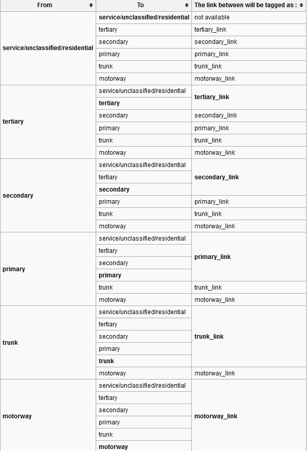
| 12650808 | about 8 years ago | Can I drop you a line, 5 years later? Recently, a new mapper has made many changes in the area, for the most part road re-classifications (some to your re-classifications). One change set had 75 ways changed. Willow was naively made into a "trunk_link". Any way, as you seem to have an opinion on the matter, I wondered if you might take a look at the highway type samples on the Lansing area Wiki page (osm.wiki/Lansing,_Michigan#Highway) and tell me what you think. For instance, do you still stand by your above opinion on secondary and tertiary roads in Michigan? Thank you. |
| 52969163 | about 8 years ago | Welcome to OSM mapping! I believe MLK is likely a primary highway, though leaving it as a secondary highway would have been fine. Please refer to the Highway designations (with Lansing examples) found on Lansing's Wiki page.
There is also a To Do item on this page, that I could use your help with.
|
| 52969465 | about 8 years ago | I've added these resources to the Lansing Wiki page. |
| 52969465 | about 8 years ago | Here are two more resources: International Equivalence
Highway Linking Guide
|
| 52969465 | about 8 years ago | Sorry if that sounded hash. |
| 52969465 | about 8 years ago | I noticed a problem with Willow, just west of MLK, and now see that has been changed to "trunk_link". I'm not sure where you got that designation, but that does not seem right. Tertiary was definitely a better fit. Did you change 42 ways in one change set... likely incorrectly? It would be a good idea to make your changes in smaller batches and ask someone before making major changes. Lansing now has a OSM Wiki and Forum, the links are below, if you would like to join. Highways osm.wiki/Highways
Lansing OSM Wiki
Lansing Forum
|
| 51821826 | over 8 years ago | Love the work on cycling features. Thanks! During a concert, at Adado Park, I considered making the same change. Using this section of trail (way/518695910) I experimented with the tags I thought appropriate. But never got around to completing thought. |
| 51155875 | over 8 years ago | I completely understand. |
| 51155875 | over 8 years ago | It is great to have another Lansing mapper. I'm not sure that the nodes you added, with only a Name tag will ever be rendered. You may want to at least add shop=yes ( shop=* "Shop yes" in OSMand) or office=* ( office=* "Administrative office" in OSMand ) tags to them. |
| 50145151 | over 8 years ago | Nice work! Thanks. |
| 49805417 | over 8 years ago | I know that area well and that line does not make sense. I'll remove it for now. hfly hh, if you would like help with this, let me know. Removal changeset: changeset/49954816 |
| 49479307 | over 8 years ago | There was already a Cheddar's POI here and a building here. Rather than combine and clean these up, you have added another POI. There are also other problems, for instance, the street name is wrong and the City, Zip and loc_name tags are redundant. I would correct these, however, I am sure that you are pushing changes to OSM without taking into consideration its current state. Thus, any changes I might make, would be overwritten the next change that you push. |
| 48987590 | over 8 years ago | Changeset description should read:
|
| 47912826 | over 8 years ago | I stand corrected by the following article... |
| 47912826 | over 8 years ago | I could be wrong and in this case, it might be fine. However, it has been my experience that it is preferred to have a generic building, with a detailed POI Node. ... It is simple matter to upgrade a POI, by surrounding it with a generic building. It works well for buildings containing multiple POI nodes. Some editors, like OSMand, will only allow editing POI nodes. Google seems to be doing well with the generic building and detailed POI technique. Etc. |
| 47383264 | over 8 years ago | I know better. It is "right OF way", not "right-a-way". Not enough coffee. |
| 46667079 | almost 9 years ago | Thanks for joining the fun and mapping Evergreen Cycles. Just so you know, only the house number, street and occasionally an addr:unit need to be tagged. "Tags such as Key:addr:country, Key:addr:city, Key:addr:postcode are often redundant as features inside administrative boundaries (when mapped) "inherit" their attributes..." -- osm.wiki/Addresses |