somix's Comments
| Changeset | When | Comment |
|---|---|---|
| 134138820 | over 2 years ago | changeset/134499195 Исправил |
| 134182251 | over 2 years ago | Детализация двора, добавил дорожки к подъездам |
| 134138820 | over 2 years ago | Извиняюсь, мне показалось, что на дороюках стоит access=private, перепутал с другим ЖК |
| 134060009 | over 2 years ago | Здравствуйте. В названии не должно быть сокращений |
| 133523152 | almost 3 years ago | 5000-ый changeset |
| 133368200 | almost 3 years ago | Вы видать не поняли, о чем речь. С названиями на татарском никаких вопросов нет, и вообще они были добавлены до него. Вопросы с названиями на английском |
| 133436851 | almost 3 years ago | ref остановок, источник - карта на станции метро |
| 133371243 | almost 3 years ago | также использовал ЯПанорамы |
| 133368200 | almost 3 years ago | Здравствуйте! А что это за переводы такие странные? Сомневаюсь, что буквы, которые вы используете, есть в английском. |
| 132375961 | almost 3 years ago | the source page doesn't exist |
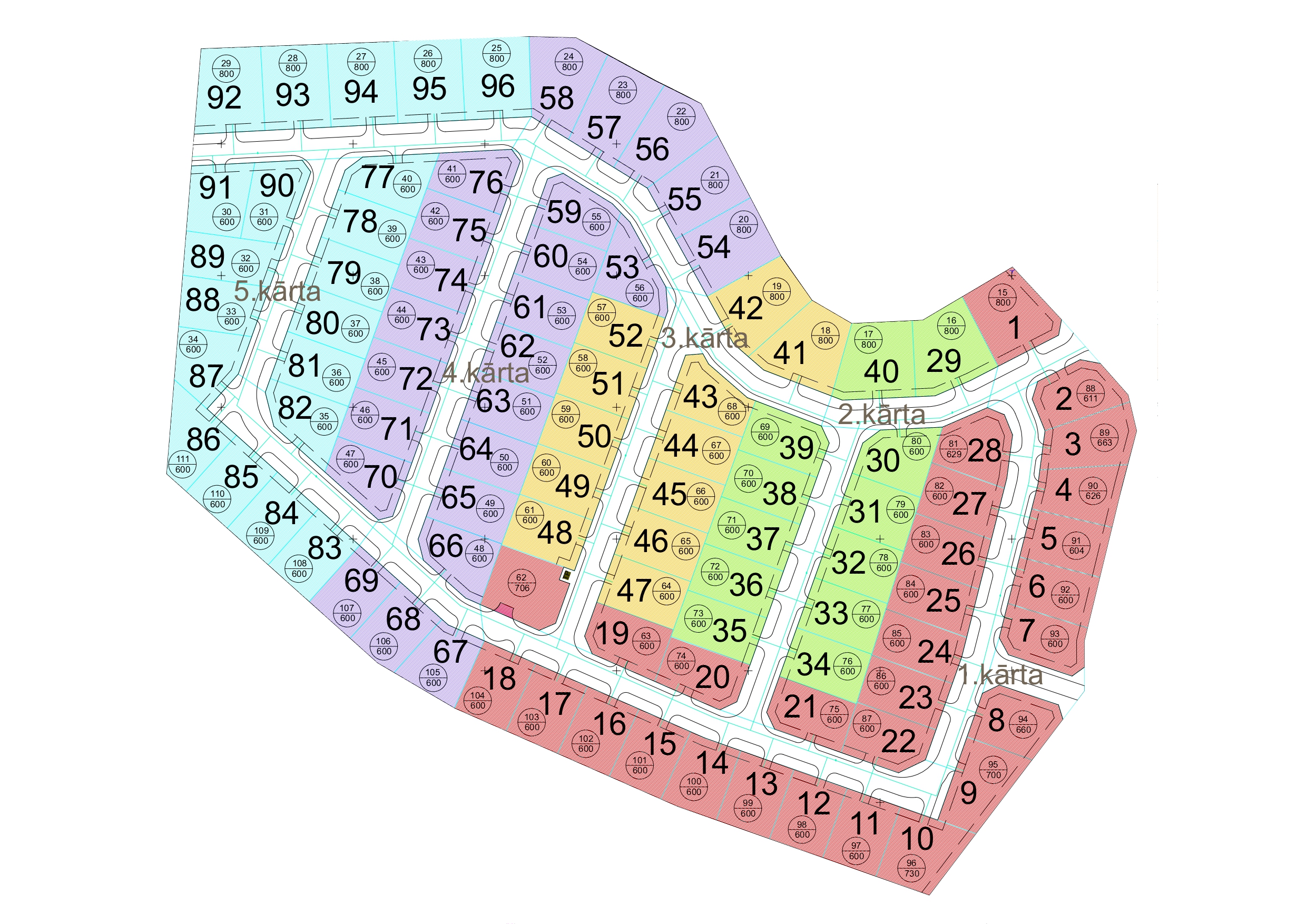
| 125242807 | almost 3 years ago | Hi! https://www.labamaja.lv/zeme/zeme-salaspils-tango-lv.html this land company website says that all roads (which are proposed/not mapped are built). There's also a village plan on this website: https://www.labamaja.lv/image/catalog/%203%20%D0%9F%D0%9E%D0%A1%D0%95%D0%9B%D0%9E%D0%9A/Tango/Vecmigli_5%20%20karta_page-0001.jpg. Also, looking at the photos, i can see that there's a living zone in this village. |
| 131939790 | almost 3 years ago | Thanks for understanding :) |
| 131939790 | almost 3 years ago | Hello, please don't add names like this. If the object don't have a real name, don't add a name. Description shouldn't be a name. |
| 131525435 | almost 3 years ago | Hi, why did you change "name" to "loc_name" here way/152163769? |
| 131235502 | almost 3 years ago | Здравствуйте, OSM не место для личных заметок. Не надо мусорить на карте |
| 129708997 | about 3 years ago | Здравствуйте, а вы уверены, что intermediate? Там же вроде асфальт новый идеально ровный |
| 129339813 | about 3 years ago | Small roads in the village, are not secondary, even if they are class "V" roads. |
| 129147095 | about 3 years ago | Hi As the wiki says:
I delete isolated dwellings if there's nothing there (node/2073747741/history) or there's buildings with different addresses in that place, which means this dwelling is not really isolated. Also, from wiki: The whole settlement must not consist of more than 2 households. |
| 128543684 | about 3 years ago | Hi
|
| 126796969 | about 3 years ago | Здравствуйте! Для урочищ есть более подходящий тег: place=locality. |