OpenStreetMap logo OpenStreetMap

pnorman's Diary

Recent diary entries

This is a bit less OpenStreetMap related then normal, but has to do with the Standard Tile Layer and an outage we had this month.

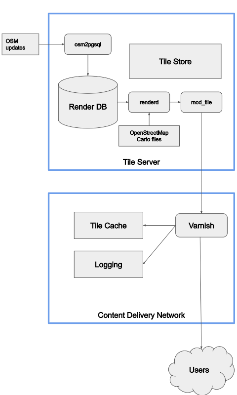
On July 18th, the Standard Tile Layer experienced degraded service, with 4% of traffic resulting in errors for 2.5 hours. A significant factor in the time to resolve the incident was a lack of visibility of the health status of the rendering servers. The architecture consists of a content delivery network (CDN) hosted by Fastly, backed by 7 rendering servers. Fastly, like most CDNs, offers automatic failover of backends by fetching a URL on the backend server and checking its response. If the response fails, it will shift traffic to a different backend.

A bug in Apache resulted in the servers being able to handle only a reduced number of connections, causing a server to fail the health check, diverting all load to another server. This repeated with multiple servers, sending the load between them until the first server responded to the health check again because it had zero load. Because the servers were responding to most of the manually issued health checks and we had no visibility into how each Fastly node was directing its traffic, it took longer to find the cause than it should have.

Our normal monitoring is provided by Statuscake, but this wasn’t enough here. Instead of increasing the monitoring, we wanted to make use of the existing Fastly healthchecks, which probe the servers from 90 different CDN points. Besides being a vastly higher volume of checks, this more directly monitors the health checks that matter for the service

During the incident, Fastly support provided some details on how to monitor health check status. Based on this guide, the OWG has set up an API on the tile CDN to indicate backend health, and monitoring to track this across all POPs.

See full entry

OpenStreetMap Carto Release v5.5.1

Posted by pnorman on 13 July 2022 in English.

Dear all,

Today, v5.5.1 of the OpenStreetMap Carto stylesheet (the default stylesheet on the OSM website) has been released. Once changes are deployed on the openstreetmap.org it will take couple of days before all tiles show the new rendering.

The one change is a bugfix to the colour of gates (#4600)

For a full list of commits, see https://github.com/gravitystorm/openstreetmap-carto/compare/v5.5.0…v5.5.1

As always, we welcome any bug reports at https://github.com/gravitystorm/openstreetmap-carto/issues

OpenStreetMap Carto release v5.5.0

Posted by pnorman on 10 July 2022 in English.

Dear all,

Today, v5.5.0 of the OpenStreetMap Carto stylesheet (the default stylesheet on the OSM website) has been released. Once changes are deployed on the openstreetmap.org it will take couple of days before all tiles show the new rendering.

Changes include

  • Fixed colour mismatch of car repair shop icon and text (#4535)

  • Cleaned up SVG files to better align with Mapnik requirements (#4457)

  • Allow Docker builds on ARM machines (e.g. new Apple laptops) (#4539)

  • Allow file:// URLs in external data config and caching of downloaded files (#4468, #4153, #4584)

  • Render mountain passes (#4121)

  • Don’t use a cross symbol for more Christian denominations that don’t use a cross (#4587)

Thanks to all the contributors for this release, including stephan2012, endim8, danieldegroot2, and jacekkow, new contributors.

For a full list of commits, see https://github.com/gravitystorm/openstreetmap-carto/compare/v5.4.0…v5.5.0

As always, we welcome any bug reports at https://github.com/gravitystorm/openstreetmap-carto/issues

I’m working on publishing a summary of sites using tile.osm.org and want to know what format would be most useful for people.

The information I’ll be publishing is requests/second, requests/second that were cache misses, and domain. The first two are guaranteed to be numbers, while the last one is a string that will typically be a domain name like www.openstreetmap.org, but could theoretically contain a poisoned value like a space.

The existing logs which have tiles and number of requests are formatted as z/x/y N where z/x/y are tile coordinates and N is the number of accesses.

My first thought was TPS TPS_MISS DOMAIN, space-separated like the existing logs. This would work, with the downside that it’s not very future proof. Because the domain can theoretically have a space, it has to be last. This means that any future additions will require re-ordering the columns, breaking existing usage. Additionally, I’d really prefer to have the domain at the start of the line.

A couple of options are - CSV, with escaping - tab-delimited

Potential users, what would work well with the languages and libraries you prefer?

An example of the output right now is

1453.99 464.1 www.openstreetmap.org  
310.3 26.29 localhost
136.46 39.68 dro.routesmart.com
123.65 18.54 www.openrailwaymap.org
107.98 0.05 www.ad-production-stage.com
96.64 1.78 r.onliner.by
91.42 0.16 solagro.org
87.83 1.53 tvil.ru
84.88 12.98 eae.opekepe.gov.gr
74.0 2.32 www.mondialrelay.fr
63.44 1.93 www.lightningmaps.org
63.22 14.01 nakarte.me
55.1 0.74 qualp.com.br
52.77 11.25 apps.sentinel-hub.com
46.68 4.07 127.0.0.1
46.3 1.96 www.gites-de-france.com
43.47 1.15 www.anwb.nl
42.46 10.52 dacota.lyft.net
41.13 6.63 www.esri.com
40.84 0.69 busti.me

The OpenStreetMap Foundation runs several services subject to usage policies.

If you violate the policies, you might be automatically or manually blocked, so I decided to write a post to help community members answering questions from people who got blocked. If you’re a blocked user, the best place to ask is in the IRC channel #osm-dev on irc.oftc.net. Stick around awhile to get an answer.

The most important question is which API is being used. For this, look at the URL you’re calling.

If the URL contains nominatim.openstreetmap.org, review the usage policy. The most common cause of being blocked is bulk geocoding exceeding 1 request per second. Going over this will trigger automatic IP blocks. These are automatically lifted after several hours, so stop your process, fix it, wait, and then you won’t be blocked.

If you’re using nominatim but not exceeding 1 request per second, to get help you should provide the URL you’re calling, the HTTP User-Agent or Referer you’re sending, the IP you’re requesting from, and the HTTP response code.

If you’re calling tile.openstreetmap.org or displaying a map, review the tile usage policy. The most common causes of being blocked is tile scraping or apps that don’t follow the usage policy.

To get help you should provide where the map is being viewed (e.g. an app, website, or something else), the HTTP User-Agent or Referer you’re sending, the IP you’re requesting from, and the HTTP response code. For a website, you can generally get this information through the browser’s developer tools. The tile.openstreetmap.org debug page will also show you you this information.

If you’re having problems with an app that you’re not the developer of, you’ll often need to contact them, as they are responsible for correctly calling the services.

OpenStreetMap Carto release v5.4.0

Posted by pnorman on 23 September 2021 in English.

Dear all,

Today, v5.4.0 of the OpenStreetMap Carto stylesheet (the default stylesheet on the OSM website) has been released. Once changes are deployed on the openstreetmap.org it will take couple of days before all tiles show the new rendering.

Changes include

  • Added a new planet_osm_line_label index (#4381)
  • Updated Docker development setup to use offical PostGIS images (#4294)
  • Fixed endline conversion issues with python setup scripts on Windows (#4330)
  • Added detailed rendering of golf courses (#4381, #4467)
  • De-emphasized street-side parking (#4301)
  • Changed subway stations to start text rendering at z15 (#4392)
  • Updated road shield generation scripts to Python 3 (#4453)
  • Updated external data loading script to support pyscopg2 2.9.1 (#4451)
  • Stopped displaying tourism=information with unknown information values
  • Switched the Natural Earth URL to point at its new location (#4466)
  • Added more logging to the external data loading script (#4472)

Thanks to all the contributors for this release including ZeLonewolf, kolgza, and map-per, new contributors

For a full list of commits, see https://github.com/gravitystorm/openstreetmap-carto/compare/v5.3.1…v5.4.0

As always, we welcome any bug reports at https://github.com/gravitystorm/openstreetmap-carto/issues

OpenStreetMap Standard Layer: Requests

Posted by pnorman on 29 July 2021 in English. Last updated on 30 July 2021.

This blog post is a version of my recent SOTM 2021 presentation on the OpenStreetMap Standard Layer and who’s using it.

With the switch to a commercial CDN, we’ve improved our logging significantly and now have the tools to log and analyze logs. We log information on both the incoming request and our response to it.

We log

  • user-agent, the program requesting the map tile;
  • referrer, the website containing a map;
  • some additional headers;
  • country and region;
  • network information;
  • HTTP protocol and TLS version;
  • response type;
  • duration;
  • size;
  • cache hit status;
  • datacenter;
  • and backend rendering server

We log enough information to see what sites and programs are using the map, and additional debugging information. Our logs can easily be analyzed with a hosted Presto system, which allows querying large amounts of data in logfiles.

I couldn’t do this talk without the ability to easily query this data and dive into the logs. So, let’s take a look at what the logs tell us for two weeks in May.

See full entry

This blog post is a version of my recent SOTM 2021 presentation on the OpenStreetMap Standard Layer and who’s using it.

The OpenStreetMap Standard Layer is the default layer on openstreetmap.org, using most of the front page. It’s run by the OpenStreetMap Foundation, and the Operations Working Group is responsible for the planning, organisation and budgeting of OSMF-run services like this one and servers running it. There are other map layers on the front page like Cycle Map and Transport Map, and I encourage you to try them, but they’re not hosted or planned by us.

Technology

At the high level, this is the overview of the technology the OWG is responsible for. The standard layer is divided into million of parts, each of which is called a tile, and we serve tiles.

Flowchart of rendering

See full entry

As part of figuring out how to best process standard tile layer logs I had a chance to generate some charts for usage of the OpenStreetMap Standard tile layer on the day of 2021-03-14, UTC time. This was over a weekend, so there are probably differences on a weekday. I’m also only looking at tiles delivered and not including blocked tiles from scrapers and similar usage. All traffic is in tiles per second, averaged over the day.

Countries

I first looked at usage of the layer from users on openstreetmap.org and all users, by country.

See full entry

I’ve been doing some log analysis on requests to the OSMF-hosted standard tile layer on tile.openstreetmap.org. To do this I downloaded two hours worth of logs and loaded them into PostgreSQL to run some queries. The logs start at ###, and total 11GB compressed starting at 1600 UTC on 2021-02-25.

My main concern has been backend server load, so to analyze that I looked at cache misses - requests where the cache has to request a tile from the OSMF-operated backend servers. Typically the number of tiles requested is going to be five to ten times higher than the number of misses, but it will vary by zoom.

Total cache misses were 3437.4 per second.

The top five referers, as well as some interesting ones are

Referer domain Cache misses per second
None 1254.3
www.openstreetmap.org 418.7
www.openrailwaymap.org 16.0
apps.sentinel-hub.com 15.0
m.turkiye.gov.tr 13.1
localhost, on various ports 30.7
10.* IPs 14.2
Other 1675.4

The top sites vary by time and what parts of the world are awake, but most of the traffic is from the long tail of small sites, OpenStreetMap itself, or an app which should be sending a custom user-agent instead of a website with a referer.

For user-agents, I grouped different versions of some apps together. Like before, I’ve got some of the top ones, then a few interesting ones.

See full entry

Location: 0.000, 0.000

OpenStreetMap Survey by visits

Posted by pnorman on 21 February 2021 in English.

In my last post I looked at survey responses by country and their correlation with mappers eligible for a fee waver as an active contributor.

I wanted to look at the correlation with OSM.org views. I already had a full day’s worth of logs on tile.openstreetmap.org accesses, so I filtered them for requests from www.openstreetmap.org and got a per-country count. This is from December 29th, 2020. Ideally it would be from a complete week, and not a holiday, but this is the data I had downloaded.

Preview image

The big outlier is Italy. It has more visits than I would expect, so I wonder if the holiday had an influence. Like before, the US is overrepresented in the results, Russia and Poland are underrepresented, and Germany is about average.

Like before, I made a graph of the smaller countries.

See full entry

OSMF survey country results

Posted by pnorman on 17 February 2021 in English.

The board has started releasing results from their 2021 survey. I’ve done some analysis on the response rates by country.

There’s lots of data for activity on OSM by country, but for this I took the numbers from joost for how many “active contributors” there are according to the contributor fee waver criteria.

Preview image

For the larger countries, Russia is the most underrepresented country. This is not surprising, as they are underrepresented in other venues like the OSMF membership.

The US and UK are both slightly overrepresented in the survey, but less so than I would have expected based on other surveys and OSMF membership.

The smaller countries are all crowded, so I did a graph of just them.

See full entry

OpenStreetMap Carto v5.3.1

Posted by pnorman on 5 February 2021 in English.

Dear all,

Today, v5.3.1 of the OpenStreetMap Carto stylesheet (the default stylesheet on the OSM website) has been released. There are no visual changes in this release.

Changes include - Natural Earth URL changed to directly point at the NACIS CDN - Added an option to the external data loader to grant SELECT permissions on the tables

For a full list of commits, see https://github.com/gravitystorm/openstreetmap-carto/compare/v5.3.0…v5.3.1

As always, we welcome any bug reports at https://github.com/gravitystorm/openstreetmap-carto/issues

OpenStreetMap Carto release v5.3.0

Posted by pnorman on 29 January 2021 in English.

Dear all,

Today, v5.3.0 of the OpenStreetMap Carto stylesheet (the default stylesheet on the OSM website) has been released. Once changes are deployed on the openstreetmap.org it will take a few days before all tiles show the new rendering. It may take longer than normal because there are significant deployment-related changes.

  • External shapefiles for coastline and other data are now loaded into the database with a provided script.

  • The recommended indexes are now required. Attempting to render without them will result in abysmal performance.

  • amenity=embassy is no longer rendered, and office=diplomatic with diplomatic=embassy or diplomatic=consulate is instead.

  • Mini-roundabouts are rendered like a turning circle.

  • There is a new partial index for waterways

Anyone running their own install must run scripts/get-external-data.py and create the new indexes. People who are running with minutely diffs may be interested in https://github.com/openstreetmap/chef/issues/386.

Thanks to all the contributors for this release, including hiddewie, crimsondusk, pitdicker, and terminaldweller, new contributors.

For a full list of commits, see https://github.com/gravitystorm/openstreetmap-carto/compare/v5.2.0…v5.3.0

As always, we welcome any bug reports at https://github.com/gravitystorm/openstreetmap-carto/issues

Calculating label points with PostGIS

Posted by pnorman on 3 November 2020 in English.

A common task with OpenStreetMap data in PostGIS is to convert polygons to points to place labels. For simple polygons, the centroid can be used, but some shapes like C-shaped polygons, the centroid can lie outside the polygon, so ST_PointOnSurface is used. This function guarantees the point returned is within the polygon.

The only issue with ST_PointOnSurface is that it throws an exception on some invalid geometries. This isn’t a problem with a database created by a recent version of osm2pgsql which only creates valid geometries, but for older versions or other data loaders it’s unacceptable. This has lead people to writing wrapper functions that check the validity or catch the exceptions, but I’ve seen no benchmarking of the various options.

To benchmark the options, I loaded the planet data from 2020-10-12 and looked at named water polygons - those that matched ("natural" = 'water' OR waterway = 'riverbank') AND name IS NOT NULL. To make the system better reflect a tile server under load, I set max_parallel_workers_per_gather to 0 and jit to off. I then ran the query EXPLAIN ANALYZE SELECT function(way) FROM planet_osm_polygon WHERE ("natural" = 'water' OR waterway = 'riverbank') AND name IS NOT NULL;.

I tested with ST_Centroid, ST_PointOnSurface, ToPoint from postgis-vt-util, a function that checked validity before calling ST_PointOnSurface, a function that caught the exception from invalid geometries, and a function that used ST_Centroid for polygons with 4 corners and ST_PointOnSurface otherwise. The definitions are at the end of this post.

Function Time
ST_Centroid 277s
ST_PointOnSurface 408s
ToPoint 575s
point1 568s
point2 409s
point3 409s

Parallelism

See full entry

Cross-posted from my blog

I’ve been working on a new project, OpenStreetMap Cartographic. This is a client-side rendering based on OpenStreetMap Carto. This is an ambitious project, as OpenStreetMap Carto is an extremely complex style which shows a large number of features. The technical choices I’m making are designed so the style is capable of handling the load of osm.org with minutely updates.

I’ve put up a world-wide demo at https://pnorman.dev.openstreetmap.org/cartographic/mapbox-gl.html, using data from 2020-03-16, and you can view the code at https://github.com/pnorman/openstreetmap-cartographic.

Preview image

Incomplete parts

Only zoom 0 to 8 has been implemented so far. I started at zoom 0 and am working my way down.

Admin boundaries are not implemented. OpenStreetMap Carto uses Mapnik-specific tricks to deduplicate the rendering of these. I know how I can do this, but it requires the changes I intend to make with the flex backend.

See full entry

OpenStreetMap Carto release v5.0.0

Posted by pnorman on 19 March 2020 in English.

Dear all,

Today, v5.0.0 of the OpenStreetMap Carto stylesheet (the default stylesheet on the OSM website) has been released. Once changes are deployed on the openstreetmap.org it will take couple of days before all tiles show the new rendering.

Changes include - An update to Lua tag transforms, setting line vs polygon decisions for new tags

  • Added upper way_area limits to most features using ST_PointOnSurface to avoid performance problems from large polygons

  • Moved MSS files into their own directory

  • Removed rendering of power=cable features

  • Removed overlay pattern for natural=sand

  • Reduced landcover fading at mid-low zoom levels

  • Removed rendering of barrier=kerb

Thanks to all the contributors for this release.

For a full list of commits, see https://github.com/gravitystorm/openstreetmap-carto/compare/v4.25.0…v5.0.0

As always, we welcome any bug reports at https://github.com/gravitystorm/openstreetmap-carto/issues

OpenStreetMap Carto release v4.22.0

Posted by pnorman on 28 August 2019 in English.

Dear all,

Today, v4.22.0 of the OpenStreetMap Carto stylesheet (the default stylesheet on the OSM website) has been released. Once changes are deployed on the openstreetmap.org it will take couple of days before all tiles show the new rendering.

Changes include

  • Shop label fixes and use ST_PointOnSurface for building label placement

    This fixes some bugs and makes building label placement consistent with shop label placement.

  • Use cache-feature: true to improve performance of layers with attachments

  • Use retail colour fill on malls

  • Drop https://wiki.openstreetmap.org/wiki/Tag:highway=steps from zoom 13

    This makes step rendering consistent with footways

  • Render https://wiki.openstreetmap.org/wiki/Tag:place=locality from zoom 16

    This fits current usage of the tag and what it is normally tagged on.

  • Render https://wiki.openstreetmap.org/wiki/Tag:natural=bay from linear ways

  • Render administrative boundary labels from relations only

  • Stop rendering natural=marsh

    It is recommended marshes are tagged with https://wiki.openstreetmap.org/wiki/Tag:natural=wetland + https://wiki.openstreetmap.org/wiki/Tag:wetland=marsh

  • Use a whitelist for barrier rendering, and render https://wiki.openstreetmap.org/wiki/Tag:historic=citywalls like https://wiki.openstreetmap.org/wiki/Tag:barrier=city_wall.

  • Support new Tibetan font name

    Noto has renamed Noto Sans Tibetan to Noto Serif Tibetan. The old name is still supported.

  • Code cleanups to increase reuse and improve consistency

Thanks to all the contributors for this release, including daveol and btwhite92, new contributors, and jeisenbe, a new maintainer.

For a full list of commits, see https://github.com/gravitystorm/openstreetmap-carto/compare/v4.21.0…v4.22.0

As always, we welcome any bug reports at https://github.com/gravitystorm/openstreetmap-carto/issues

Dear all,

Today, v4.21.0 of the OpenStreetMap Carto stylesheet (the default stylesheet on the OSM website) has been released. Once changes are deployed on the openstreetmap.org it will take couple of days before all tiles show the new rendering.

Changes include - Removed unused world_boundaries-spherical.tgz file from scripts

  • Switch to osmdata.openstreetmap.de for water & icesheet shapefiles

  • Started using ST_PointOnSurface for some label placements

  • Adjusted index for military areas

  • Adjusted starting zooms for labeling of administrative areas.

  • Revert rendering of healthcare key

  • Stop place some place labels when the objects become too big or at high zooms.

  • Only render capes as points and render them like other points.

  • Only render ferry lines from ways, not relations

  • Improved developer internal documentation

Thanks to all the contributors for this release including Nakaner, a new contributor.

For a full list of commits, see https://github.com/gravitystorm/openstreetmap-carto/compare/v4.20.0…v4.21.0

As always, we welcome any bug reports at https://github.com/gravitystorm/openstreetmap-carto/issues

Matrix of OSMF candidates and questions

Posted by pnorman on 1 December 2018 in English.

There’s a healthy number of candidates for OSMF board this year, so I made a matrix of candidates and the questions they were asked, and thought it might be useful to others too.

I’ll be using this and putting + or - in the squares so I can keep rough track of if I believe their positions make them good board candidates. I won’t just be adding them up in the end - not all questions are equally important to me - but something to organize my thoughts is useful.