olehz's Comments
| Changeset | When | Comment |
|---|---|---|
| 137030172 | over 1 year ago | Could you explain why you removed so many substations in Belarus? |
| 137030461 | over 1 year ago | Why did you remove power=substation and add building=yes? Is there a reason or is it vandalism? |
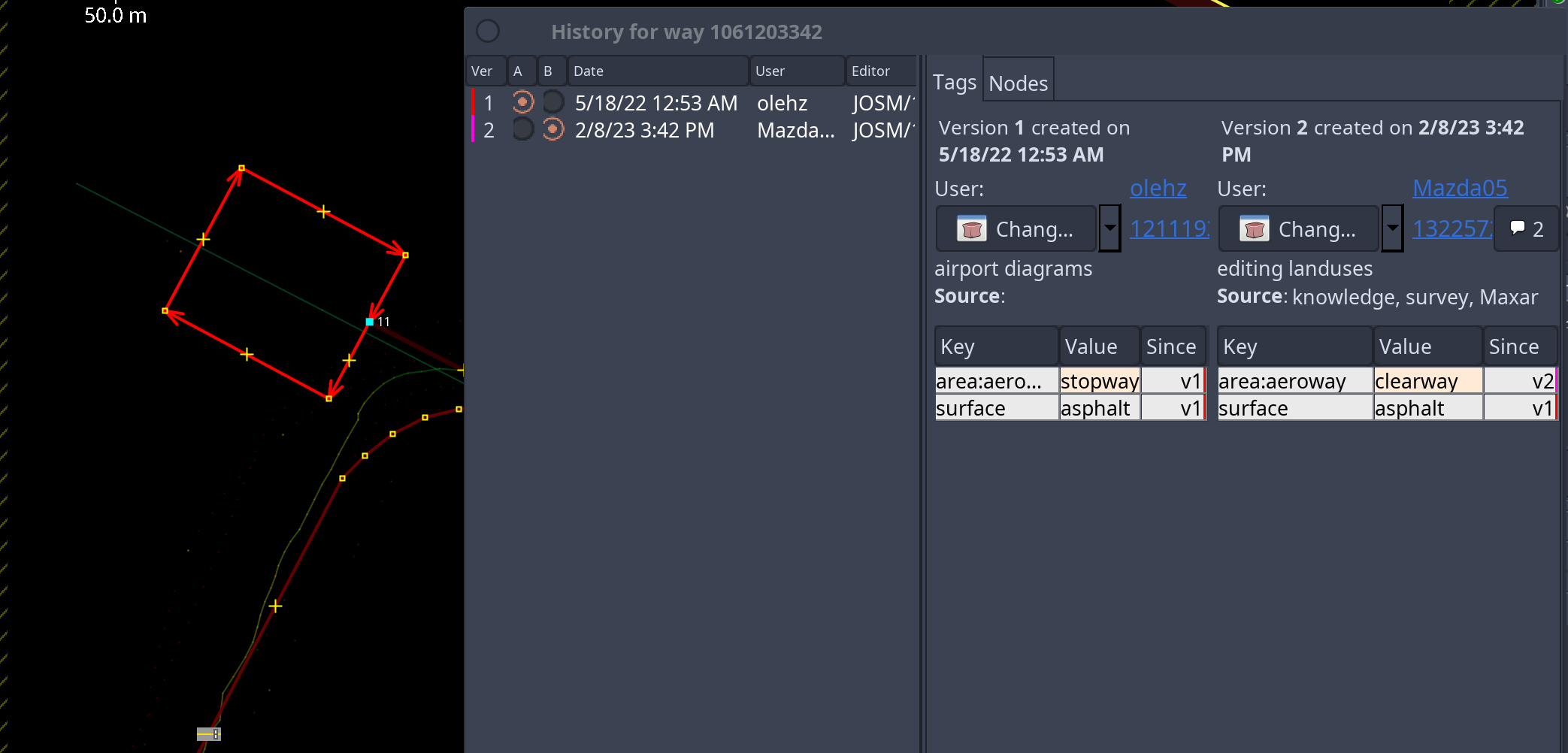
| 132257255 | over 1 year ago | I'm the author of this map (http://vfr-demo-map.s3.eu-west-1.amazonaws.com/map.html), so I guess I know the diff. For instance: https://vfr-demo-map.s3.eu-west-1.amazonaws.com/mazda.png In this case it's obviously stopway/blastpad. CWY is not used in AMDB at all - https://vfr-demo-map.s3.eu-west-1.amazonaws.com/ed-99-mapping-to-aixm_compress.pdf |
| 132257255 | over 1 year ago | Why did you change the airport diagrams? For instance area:aeroway stopway => clearway? This is nonsense. Did it bother you? The standard render does not understand such tags anyway. I just wasted my time drawing according to the AMDB scheme. Even RWY polygons were removed. (( |
| 146938510 | over 1 year ago | Тут близько до лінії фронту, тому не чіпав. Але таких ситуацій з частково демонтованими лініями багато. Як зробити аби люди не міняли на маячню через валідатор? |
| 146938510 | over 1 year ago | Resolve issue - це з недіючої лінії зробити діючу і домалювати фейкові сегменти і склеяти 35кв з 10кв? Прикольне покращення ) |
| 141555869 | about 2 years ago | Lovers of dictatorships from Russia/Serbia/Hungary have no relation to the Danish airport. There's nothing to discuss here |
| 141555869 | about 2 years ago | I want to apologize. Anyway, I hate Russia and Serbia (mini russia), you killed my friends and destroyed my future. So I don't see any constructive conversations. Fuck off and good bye. |
| 141555509 | about 2 years ago | See: changeset/141555869 |
| 141555869 | about 2 years ago | My company uses OSM as one of the sources for drawing airport diagrams (https://www.youtube.com/watch?v=L7sMxRg-JvM) and your proposal is very bad from this point of view. |
| 141555869 | about 2 years ago | I look at the problem from the point of view of aviation and land use, and you from the point of view of routing. You can tag the building rather than remove the official UN codes. |
| 141555869 | about 2 years ago | https://skybrary.aero/articles/airport-mapping-database-amdb |
| 141555869 | about 2 years ago | > Please provide source where is explicit explained to not divide airfields into two parts Lol. You yourself wrote that the IATA code is identical. This is one airport that has mixed MIL/CIV uses and uses the same RWYs. But it is impossible to determine this geometrically in OSM. In fact, the airport diagrams in OSM are simply terrible. This is very worse than the AMDB standard. And your proposal to ignore the IATA code, which in fact exists, seems strange to me. |
| 141555869 | about 2 years ago | It's incorrect to divide the airfield into 2 parts (civilian and military). They use a common runway after all. |
| 141555509 | about 2 years ago | It's incorrect to divide the airfield into 2 parts (civilian and military). They use a common runway after all. |
| 142678950 | about 2 years ago | AMDB: https://vfr-demo-map.s3.eu-west-1.amazonaws.com/ed-99-mapping-to-aixm_compress.pdf |
| 142678950 | about 2 years ago | These are different entities. Сlosed taxiways or runways are specially marked and can be used. You are proposing a poor scheme that is very far from AMDB standards. Compare the quality of airport diagrams. AMDB (Europe + USA), OSM - other small airports - http://vfr-demo-map.s3.eu-west-1.amazonaws.com/map.html |
| 143436150 | about 2 years ago | знову зсунув з треків. чим так краще - незрозуміло |
| 142650371 | about 2 years ago | магія. історично будівлі за одним проектом (чого у нас повно, від Польщі до сільських хат срср) всі були накопійовані. |
| 142650371 | about 2 years ago | були паралельні однакові панельні будинки. нє, тре в черговий раз прийти все посовати і зробити їх різними |