muralito's Comments
| Changeset | When | Comment |
|---|---|---|
| 88211516 | over 5 years ago | This is riverbank, not coastline. I think you are wrong, and one proof is that many islands of river origin continue to accumulate and emerge. Another is that it would not be navigable by ships without the continuous dredging that is done to the shipping channel. It is fresh water. It is a river, a river bank, not a coastline. The coastline is for the oceans, not for rivers. Why is it so hard to understand? Using the tag natural=coastline to model where there is water and where there is none (for the renderer), is wrong, as happened with the Great Lakes and it was corrected in a timely manner, just like this one, that every so often they want to model it wrong so as not to fix the render. and they don't seem to have the courage to admit it. And in the real word the coastline is a discontiue line in the mouth of every water course that ends in the ocean.+
Last week i also went from Montevideo to Punta del Este, and several beaches in between them, to try to see if i am wrong, and I am not, believe me, it's absolutely clear that the cut of the coastline should be done in Punta del Este. It is there where all the geographic featues of the coastline changes. |
| 60393564 | over 5 years ago | Tampoco se si sirve generalizar lo de La Plata a todo el territorio. En La Plata no dicen "Calle", solo los numeros, como Berlina en la 10 y 49. Los carteles que yo vi el año pasado solo tenian el numero, no recuerdo haber visto ni un solo nombre por donde recorri, en la zona centrica, la catedral, la Casa Curuchet, etc. Además con las varias personas que hable, preguntando por consejos, nunca me dieron un nombre de calle, solo numeros. Carteles a la pared como se muestran aca http://nomenclaturas.blogspot.com/ no vi ninguno, no digo que no estén, pero yo solo vi de los modernos, los que estan en postes. Y las placas son mas homenaje que carteleria vial. |
| 68727600 | over 5 years ago | Sure, the treaty https://www.comisionriodelaplata.org/archivos/documentos/TratadodelRiodelaPlataysuFrenteMaritimo.pdf (ARTICULO 1. El Río de la Plata se extiende desde el paralelo de Punta Gorda hasta la línea recta imaginaria que une Punta del Este (República Oriental del Uruguay) con Punta Rasa del Cabo San Antonio (República Argentina), de conformidad a lo dispuesto en el Tratado de Límites del Río Uruguay del 7 de abril de 1961 y en la Declaración Conjunta sobre el Límite Exterior del Río de la Plata del 30 de enero de 1961.") The "Hito Paralelo Punta Gorda" is here node/1956070341 https://commons.wikimedia.org/wiki/File:Hito_del_paralelo_de_Punta_Gorda,_detalle_de_placas.jpg The wikipedia article you linked lacks the accuracy with the definition. |
| 68727600 | over 5 years ago | This way way/192164373 is Rio de la Plata, and you changed to Rio Uruguay, and also modified both waterway relations. |
| 68727600 | over 5 years ago | hi yaguenka please do not "fix" Rio Uruguay and Rio de la Plata like this. They were mapped right and the chenge you did is wrong. You also changed rivers in this changeset all around the world, and if you also chenged them without knowing what are tou doing, maybe also all these waterway changes need to be reveiwed. Thanks. |
| 88419220 | over 5 years ago | If you map like this, you broke the exit count... |
| 88422342 | over 5 years ago | Es decir, para ingresar a la autopista los automovilistas deberian ir por la colectora hasta el acceso legal mas cercano, y no usar estos accesos "piratas". |
| 88422342 | over 5 years ago | Hola. Asi es como se mapean los accesos "piratas". Son accesos que no es legal usarlos, pero están creados y se usan,.. |
| 88211516 | over 5 years ago | The discusion is here because this changeset moved the coastline. It seems you point my changest as wrong, changeset/79221942 but the problem was a few days before that with changeset/79221942 and now with this changeset moving the coastline where it does not belong. I just don't undertstand what new consensus you are looking for, as there has been consensus for years. There is nio need for discussion, nor here, nor in the wiki. Nor do I need to convince joto to fix their script. it's their their script, so its their decision the limit they choose. But the coastline is not where this changeset put it, so i will revert as soon as posible.
|
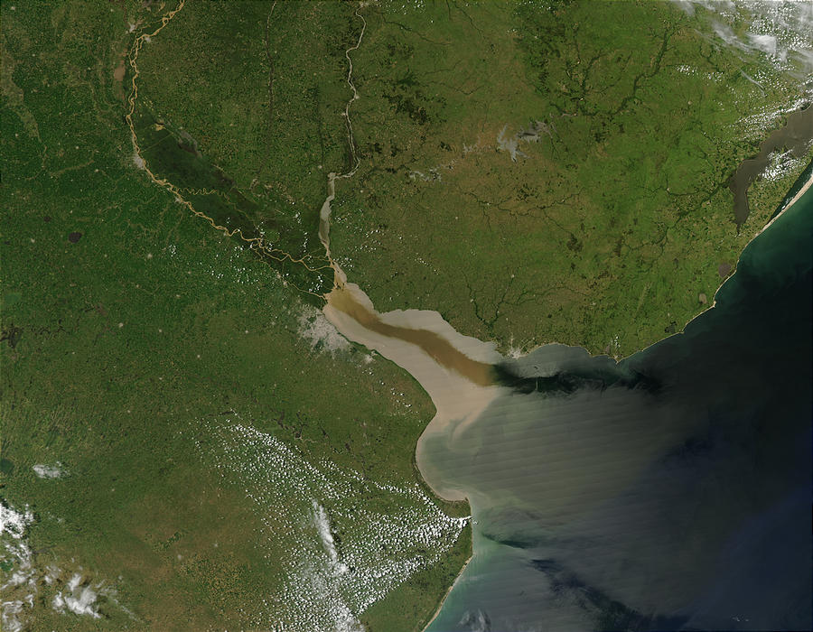
| 88211516 | over 5 years ago | First of all these aereial image are artifically coloured, doesnt it? In addition, this photo clearly shows how far fresh water reaches, which even exceeds the Punta del Este-Punta Rasa limit. https://upload.wikimedia.org/wikipedia/commons/c/cf/River_Plate.jpg
Second, the limit of the river with the ocean, where the salinity changes is in Punta del Este and Punta Rasa., which is accepted decades ago by the IHO. The Third, as I mentioned before, the tides are micro tides, at most half a meter. the determining factor of the tidal height in the Rio de la Plata is the meteorological one, that is, the direction from which the wind blows. When the wind helps drain the river, you can see the water go away even 100 or 200 meters, the ports are dry with sailboats stranded. When the wind stops the flow of the river, the level of the river rises several meters, that the beaches are not almost visible, but it is not like in other parts of the world, it is not cyclical, it is not periodic, it only depends on the wind, its strength and direction. It is not oceanic tide, it is meteorological tide. Just came here and taste the water. |
| 88211516 | over 5 years ago | The coastline was in the limit of the river with the ocean for years. Some months ago some user altered it and i restored it. But the difference that broke the script shouldn't be here. |
| 88211516 | over 5 years ago | a one-time change to the maximum script limit, coordinated with the atomic change of the coastline, it's what seems better, in terms of less work, and less prone to errors than progressively making many changes to the coastline in small stretches, each they can introduce errors without detecting them. |
| 88211516 | over 5 years ago | Some people just do not understand that not all places in the world are the same and keep insisting in applying their local knowledge and experience where it is not valid anymore. Rio de la Plata has a discharge of 26 000 m³/s, orders of magnitude grater than rivers in Europe, so i know that is difficult for some people to understand the differences when they are used to other facts. |
| 88211516 | over 5 years ago | And the data was rigth, so its the script and their choices what should be fixed. |
| 88211516 | over 5 years ago | No, you are completly wrong. It not salt water, and no tidal, only microtidals and some days every year meteorological when the wind stop the water flowing to the ocean. |
| 88211516 | over 5 years ago | OK, I do not know why replacing a simple coastline of two ways by a complex polygon (~700) of small lines can help you, and what have this to do with updates to the coastline not being done. Please explain what you mean to do it in small chunks, as If the coastline change is not done in one single changeset atomically, the coastline would be broken until all tne small chunks where uploaded. |
| 88211516 | over 5 years ago | This is not an attepmt to fix coastline, as the coastline was not broken. Rio de la Plats is not ocean, and it is not coastline.
|
| 88108867 | over 5 years ago | Pueden demorar algunas horas en aparece segun lo cargado que esten los servidores. Veo que le agarraste la mano, Ojala puedas dejar tu localidad mapeada con un buen detalle, asi le sirve tanto a los locales, pero mucho más a los visitantes.. Te fellicito! |
| 88038376 | over 5 years ago | Revisa si quedo ahora. Es parecido a lo de los galpones. Dibuje los predios por un lado, y ahi lleva las etiquetas de escuela, y los edificios por otro, que solo llevan las etiquetas de edificio. y como los predios con grandes les puse una entrada donde supongue que esta. si miras en el mapa es un cuadrado chiquito que se muestra. Esto es porque al ser predios grandes es bueno marcar la entrada para guiar a la gente directo a la puerta. |
| 88042199 | over 5 years ago | Mejor. Igual mirá como los deje ahora, que hay una diferencia sutil.
Sentite confiado y cambialo si mi suposicion es errada. |