muralito's Comments
| Changeset | When | Comment |
|---|---|---|
| 88211516 | over 5 years ago | The discusion is here because this changeset moved the coastline. It seems you point my changest as wrong, changeset/79221942 but the problem was a few days before that with changeset/79221942 and now with this changeset moving the coastline where it does not belong. I just don't undertstand what new consensus you are looking for, as there has been consensus for years. There is nio need for discussion, nor here, nor in the wiki. Nor do I need to convince joto to fix their script. it's their their script, so its their decision the limit they choose. But the coastline is not where this changeset put it, so i will revert as soon as posible.
|
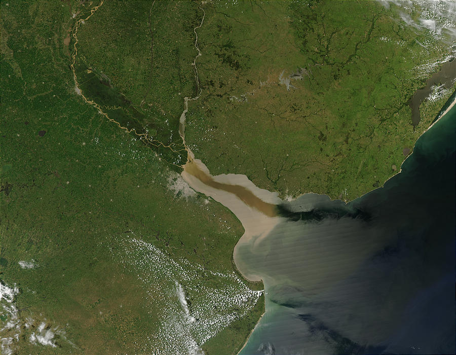
| 88211516 | over 5 years ago | First of all these aereial image are artifically coloured, doesnt it? In addition, this photo clearly shows how far fresh water reaches, which even exceeds the Punta del Este-Punta Rasa limit. https://upload.wikimedia.org/wikipedia/commons/c/cf/River_Plate.jpg
Second, the limit of the river with the ocean, where the salinity changes is in Punta del Este and Punta Rasa., which is accepted decades ago by the IHO. The Third, as I mentioned before, the tides are micro tides, at most half a meter. the determining factor of the tidal height in the Rio de la Plata is the meteorological one, that is, the direction from which the wind blows. When the wind helps drain the river, you can see the water go away even 100 or 200 meters, the ports are dry with sailboats stranded. When the wind stops the flow of the river, the level of the river rises several meters, that the beaches are not almost visible, but it is not like in other parts of the world, it is not cyclical, it is not periodic, it only depends on the wind, its strength and direction. It is not oceanic tide, it is meteorological tide. Just came here and taste the water. |
| 88211516 | over 5 years ago | The coastline was in the limit of the river with the ocean for years. Some months ago some user altered it and i restored it. But the difference that broke the script shouldn't be here. |
| 88211516 | over 5 years ago | a one-time change to the maximum script limit, coordinated with the atomic change of the coastline, it's what seems better, in terms of less work, and less prone to errors than progressively making many changes to the coastline in small stretches, each they can introduce errors without detecting them. |
| 88211516 | over 5 years ago | Some people just do not understand that not all places in the world are the same and keep insisting in applying their local knowledge and experience where it is not valid anymore. Rio de la Plata has a discharge of 26 000 m³/s, orders of magnitude grater than rivers in Europe, so i know that is difficult for some people to understand the differences when they are used to other facts. |
| 88211516 | over 5 years ago | And the data was rigth, so its the script and their choices what should be fixed. |
| 88211516 | over 5 years ago | No, you are completly wrong. It not salt water, and no tidal, only microtidals and some days every year meteorological when the wind stop the water flowing to the ocean. |
| 88211516 | over 5 years ago | OK, I do not know why replacing a simple coastline of two ways by a complex polygon (~700) of small lines can help you, and what have this to do with updates to the coastline not being done. Please explain what you mean to do it in small chunks, as If the coastline change is not done in one single changeset atomically, the coastline would be broken until all tne small chunks where uploaded. |
| 88211516 | over 5 years ago | This is not an attepmt to fix coastline, as the coastline was not broken. Rio de la Plats is not ocean, and it is not coastline.
|
| 88108867 | over 5 years ago | Pueden demorar algunas horas en aparece segun lo cargado que esten los servidores. Veo que le agarraste la mano, Ojala puedas dejar tu localidad mapeada con un buen detalle, asi le sirve tanto a los locales, pero mucho más a los visitantes.. Te fellicito! |
| 88038376 | over 5 years ago | Revisa si quedo ahora. Es parecido a lo de los galpones. Dibuje los predios por un lado, y ahi lleva las etiquetas de escuela, y los edificios por otro, que solo llevan las etiquetas de edificio. y como los predios con grandes les puse una entrada donde supongue que esta. si miras en el mapa es un cuadrado chiquito que se muestra. Esto es porque al ser predios grandes es bueno marcar la entrada para guiar a la gente directo a la puerta. |
| 88042199 | over 5 years ago | Mejor. Igual mirá como los deje ahora, que hay una diferencia sutil.
Sentite confiado y cambialo si mi suposicion es errada. |
| 88105954 | over 5 years ago | Hola. A los landuse =residential no conviente ponerle nombre en "name" porque si te fijas termina siendo renderizado en varias veces cuando el nombre ya esta en el elemento "place". Si queres describir lo podes poner en "description". Y con las relaciones tenes que tener mas cuidado, porque Shangrila estaba definido como barrio, y le borraste todo eso y solo lo dejaste como landuse. Acordate, el landuse va por un lado, la definicion de que son los elementos en cuanto a lugares, servicios o funciones van por otro, No conviene mezclar cosas de distinta especie. El otro tema es los limites de los barrios, que por los nombres que les has puesto quedan dibujados por fuera de lo que ya estaban. Lo que estaba era tomado del INE como la fuente de datos que teniamos, no quiere decir que no se pueda mejorar, pero hay que ver que fuente se termina usando, si INE, catastro, la intendencia, etc, y no mezclandolas porque termina el mapa con cualquier cosa, |
| 88042443 | over 5 years ago | No, agregar una relacion como limite administrativo no tiene que ver con que sea area, es para paises, departmentos, ciudades, etc. Y una relacion de limite puede tener adentro muchos elementos, el limite en si, el centro administrativo, otras relaciones que indiquen subareas, etc.
|
| 88042443 | over 5 years ago | Sobre la primer pregunta.
|
| 87966838 | over 5 years ago | Thank you for understanding the issue and fixing it. |
| 88043329 | over 5 years ago | Si queres, pedi ayuda a la comunidad por los medios que encontras aca osm.wiki/ES:Argentina que con la experiencia de la comunidad y el conocimiento tuyo de la realidad de la localidad puede quedar muy bien hecho el trabajo. |
| 88038184 | over 5 years ago | Un cajero se mapea con amenity=atm |
| 88038376 | over 5 years ago | Veo que hay verias infraestructuras educativas en el mismo predio o contiguas. Creo que hay que achicar la primaria para poder mapear la secundaria bien, dependiendo de si comparten edificios o predio. |
| 88038415 | over 5 years ago | seria amenity=kindergarden |