maning's Comments
| Post | When | Comment |
|---|---|---|
| What's your OpenStreetMap story? |
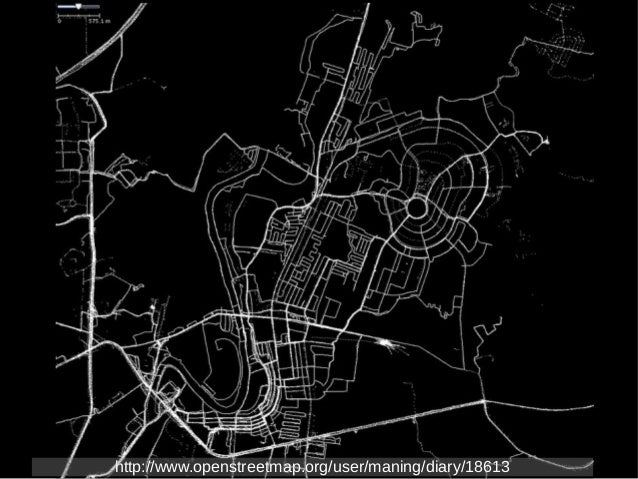
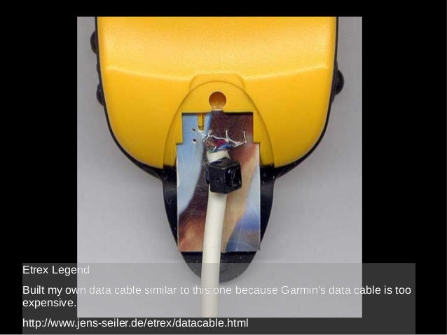
Here’s my patch as GPS tracks. I started mapping late 2006. Back then, OSM in the Philippines was completely blank. Maybe I made the first node? At first I struggled with everything, from borrowing GPSr to understanding the tools. I even tried to create a Garmin data cable since it is very expensive to buy a new one.
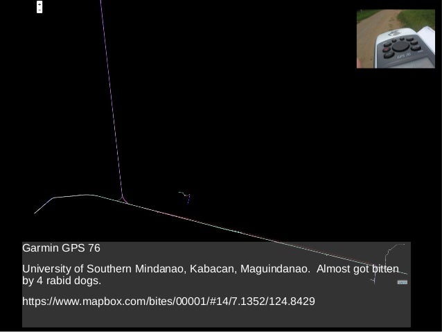
Perhaps the most stupid thing I did when I was starting was, without understanding any of the schema and API, I hand edited an OSM file because I had difficulty uploading with my flaky dial-up connection. I turned out that I completely messed up the map because I unintentionally removed negative ID values to the original data upload using JOSM! Fortunately, the talk list back then was very friendly and helped me fix it. ;) Here’s a few other mapping stories. I was nearly attacked by 4 dogs trying to map an private residential area.
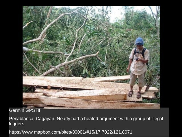
Nearly got into a heated argument with a group of illegal loggers while mapping the forests of Sierra Madre.
|
|
| Mapillary trials | I’m getting the same issue sometimes (I’m blaming my ISP). Just try clicking the blue line to see photos. You can also file a bug report at mapillary’s github account. |
|
| Water in OpenStreetMap | This is nice challenge. However, I can’t see it in the list of challenges in MapRoulette. |
|
| Iligan street map update | Great! Deteiled mapping in Iligan started after Sendong. Its good to know that there are more locals contributing. Hope you find the data useful. |
|
| Iligan street map update | Keep it up! Is this a local mapping initiative in Iligan? If you have questions, just ask. Keep on mapping! Maning OpenStreetMap-Philippines |
|
| @OsmThis: Twitter to OSM |
Fixed! |
|
| Moabi at State of the Map US | Cool! Any plans for open sourcing the code? I’m particularly interested in the iD presets. |
|
| Mapping the Gran Cordillera Central | Good luck with your docu entry! And its nice you do mapping on the side. ;) |
|
| Hello, OSM! | Hi Ken, I reported your issue in iD’s github repo, please update if the problem persists. Thanks! |
|
| We need to look at consistency of coverage in the Philippines. Let's target LOD1 first. | @/al, I updated the entry for the location of the images. If that is what you mean. |
|
| Hello, OSM! | Welcom to the “tribe”. :) |
|
| Bagong Simula | Lester, Welcome din. Sana maging makabuluhan din ang iyong pagiging contributor dito sa OSM. |
|
| Rivers in Palawan not showing on main map | Disregard my comment. My speed reading missed that part of your post. :-) |
|
| Rivers in Palawan not showing on main map | Cycle, tranport and mapquest layer looks OK. |
|
| Will @MapBox allow imagery tracing for OSM? | Now available to paid users: http://support.mapbox.com/discussions/general-questions/9924-using-satellite-images-for-osm-tracing |
|
| Using exif based geotag photos from phone to JOSM is not always reliable | What’s even more weird is when I checked the details of the photo in the phone, it reports the lat/lon to up to 15 decimals! Way too much IMO. |
|
| 1,074,201 things to do for OpenStreetMap, literally. | Great! Any plans for a worldwide coverage? |
|
| Quezon Ave - Araneta Ave Underpass Now Open but... | The underpass is now in OSM, please check later if the routing is OK. |
|
| hi-res imagery for Leyte and problems with OSM :( | If you click on the Bing Aerial (Labeled) layer in this link: http://tools.openstreetmap.org.ph/imagery_coverage/#10.3271,124.791324,17 The closed source data is even worst. Unfortunately, I cannot edit it. The problem with closed/proprietary. :) Perhaps we can also discuss this in the PH mailinglist so that other mappers can help and standardize the tags. |
|
| Good Day | Welcome! I am happy to know that your groups is interested with using OSM Bukidnon has some hi-res imagery you use for tracing data. |