jptolosa's Comments
| Changeset | When | Comment |
|---|---|---|
| 152394443 | over 1 year ago | Hola, cuál es la razón para dividir este tramo del corredor Santa Rosa si se trata claramente de una sola calzada.
|
| 151838954 | over 1 year ago | Hola,
|
| 116062060 | over 1 year ago | Yes, no problem, I can do it. |
| 116062060 | over 1 year ago | Hi, according I can understand from the wiki, it suggest the presence of the bedrock islands are located beneath the ice.
|
| 151062110 | over 1 year ago | Hola Sergio,
|
| 116062060 | over 1 year ago | Hello Aleksandar,
|
| 150316868 | over 1 year ago |
The decisions of some local communities is not compatible with definitions is some cases. There are a lot of remote islands with similar population where the maximum classification used is tertiary or unclassified. The general agree criteria for measure the importance is based on population of places. All examples shown in "assumptions" paragraph of the wiki are big/medium cities joined by a highway that crossed entire countries; that's not the point. Well, before your intervention in Fildes Peninsula was accepted "de facto" the unclassified value, then the tertiary value is a intermediate of both positions and a just solution in case of disagree. |
| 150316868 | over 1 year ago | Hello ftrebien,
|
| 150316971 | over 1 year ago | Hello, service is used to access specific building or unique property. Unclassified is used to access several buildings or at least two properties as minimum requisite. |
| 150149356 | over 1 year ago | Hola, acá has duplicado la localidad de Junquillar y moviste todo usando una alineación incorrecta nuevamente. |
| 150147758 | over 1 year ago | Hola, la alineación que estás usando es incorrecta. La capa de fotos Bing está especialmente desplazada en este lugar. Es preferible guiarse por Esri.
|
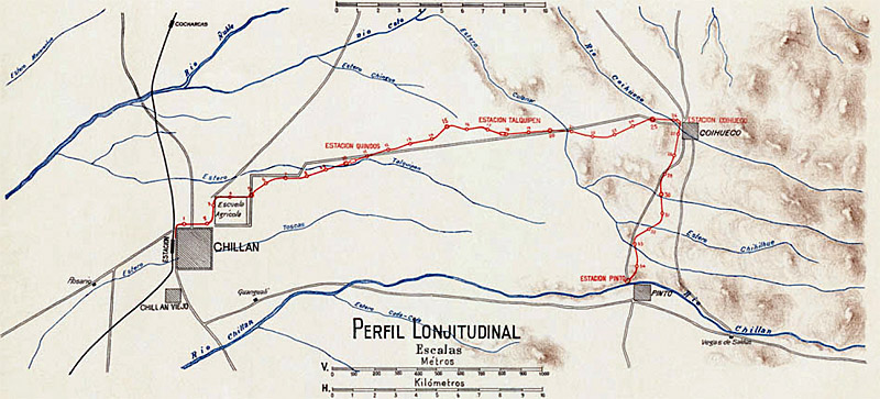
| 149530939 | over 1 year ago | Hola, según se ve en un mapa de una de las páginas que citaste, la línea doblaba hacia el sur casi hasta entrar a Pinto, del mismo modo que el artículo de Wikipedia habla de una estación con ese nombre: http://www.ferrocarrilesenelconosur.co.uk/Resources/Chillan%20map%20small.jpg |
| 149454938 | over 1 year ago | Hola.
|
| 147937150 | almost 2 years ago | Hola, que un "patio de juegos" posea un par de árboles o pequeño jardín no lo convierte en parque. Para que sea parque su función principal debe ser la de proporcionar un área verde de esparcimiento. |
| 74651141 | almost 2 years ago | Hello, the tag "Km=9" means the same as addr:milestone=9. I guess should be changed all of them. |
| 104084464 | almost 2 years ago | Hello, thanks for advice, I have fixed it. |
| 147237721 | almost 2 years ago | El polígono farmland debe excluir a los edificios, para los cuales se utiliza farmyard.
|
| 147178500 | almost 2 years ago | Un polígono landuse=farmyard sólo se debe usar para agrupar los edificios. No se debe incluir las tierras de cultivo o de pastoreo en este.
|
| 147236449 | almost 2 years ago | Hola, intermittent=no es un valor por defecto. No se debe utilizar a menos que dé lugar a creer lo contrario. |
| 146137145 | almost 2 years ago | If there are no other customers is not a reason to use service=spur. In this case the tag to denote that you say is usage=industrial. By definition a service=spur only supply the function of access to a company, in this case for track from Nueva Aldea village to Planta Nueva Aldea. |