ij_'s Comments
| Changeset | When | Comment |
|---|---|---|
| 33829123 | over 10 years ago | Kuis sä nyt poistit sen kylän sit? Se on eri asia kuin suburbi. |
| 32896554 | over 10 years ago | I'll try to remember to take a photograph once we'll visit one of such playgrounds but I cannot give any ETA for that to occur since we anyway pretty randomly pick the playgrounds where to stop (like happened for that particular school yard too). |
| 32896554 | over 10 years ago | ...And BTW, thanks for asking first when you didn't know how to fix rather than trying to come up something bogus yourself. I think it's the proper approach in case of any doubt about how to fix and results in better quality of data in the end :-). |
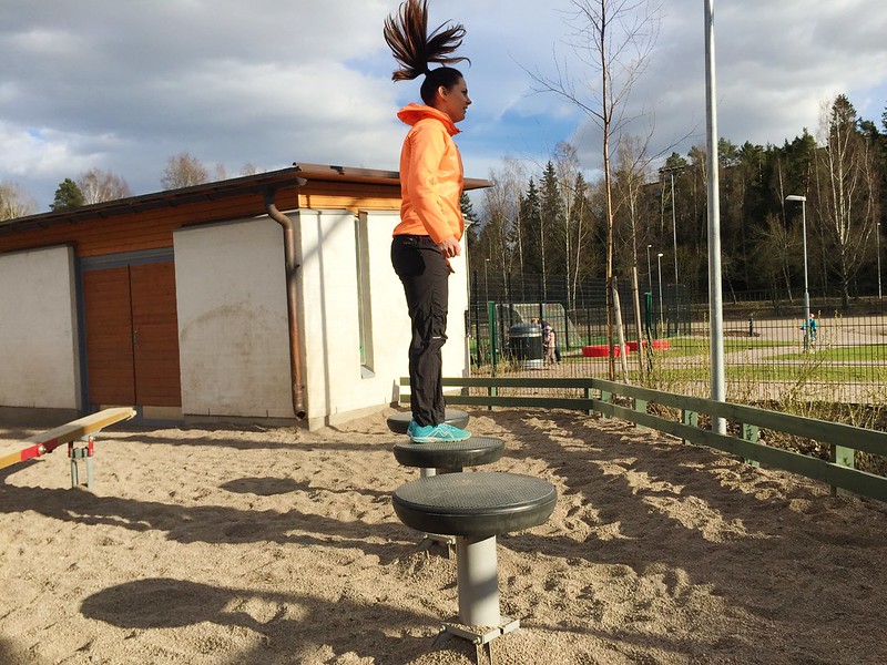
| 32896554 | over 10 years ago | It's a stick where you have a small standing platform. Up to two persons can somehow fit but mainly for single person use. The platform is 20-30cm above ground, approx 40cm diameter or so and you will be standing very close to the center of rotation if not even top of it if you're tall enough. By it's shape, a closest real world device it resembles is a spinner ("hyrrä" in Finnish) albeit it's anchored to that particular spot.
Unfortunately I couldn't find a image of one but you can imagine a pole to the center of this one:
|
| 32871753 | over 10 years ago | Ok, thanks. |
| 32871753 | over 10 years ago | Sure, but's it up to you "fixers" to do what you propose, not me (I actually was kind enough to even comb the history feed to locate this data destroying change for you so that the data does not get lost). Please either do as you proposed or revert.
|
| 32871753 | over 10 years ago | This is incorrect fix, please revert. There's only one swing with opposing seats (which both have _at least_ the capacity you've set there). |
| 32636299 | over 10 years ago | Kannattaisikohan noi vanhat osoitteet kuitenkin säilyttää nodeissa tuolla talopolyjen sisällä ja laittaa notet niille vaan että ovat vanhoja osoitteita? IMHO, osoitteiden deprekointi ei oikeasti toimi oikeassa elämässä eli vanhat osoitteet ovat hyödyllistä dataa vielä jälkipolville saakka. |
| 32550147 | over 10 years ago | Please don't remove oneway=yes just like that or did you visit the place and checked that it really is a dead-end? You're very likely wrong even if you might have tried to interpret imagery. My guess (non-verified on ground) is that one can drive around that building below the upper loading/parking lot bridges. Also, traffic_sign=FI:331 (forbidden driving direction sign) is there and even mapped to OSM to help mappers to not make mistakes like this but you didn't seem to understand enough local context to be able "fix" it correctly!! Unfortunately, using "error" tasking tools like the one you're using easily introduce errors to maps rather than fix them if you not extremely careful (and willing to admit that occassionally some "errors" are not fixable without somebody surveying what's on the ground and that they should not be "fixed" improperly in that case). |
| 32561289 | over 10 years ago | Onko tuolle Hermannin rantatielle tapahtunut mitään muuta kuin että se on suljettu ja aidattu? Ei kai sitä nyt varsinaisesti REDIn takia raksata uusiksi vai miksi nuo tiet on nyt =construction?
|
| 32561527 | over 10 years ago | Tässä poistit yhden kerätyn liikennemerkin (node/3514422229/history)... onko kyseessä vahinko vai tarkoitus? |
| 31702766 | over 10 years ago | Thanks for adding the Swedish streetnames, however, you should retain name=* so that it matches the Finnish streetname and also name:fi must not be removed like you did. Only add Swedish name to name:sv. This applies to most names in Finland but in case you add Swedish streetnames into "kunta" that has Swedish speaking majority, then put also the Swedish streetname into name too.
|
| 31372595 | over 10 years ago | Hei, Kysyisin sellaista pientä detailia, että ovatko nuo rapunovet todella aivan "nurkassa" (esim. 45 asteen kulmassa) vai ovatko ne oikeasti jommalla kummalla seinällä kulman vieressä (kuten yleisempi tapaus on)? Josset tiedä suoralta kädeltä, niin ei haittaa paljoa jos jäävän noi kuin ovat, mutta pääsääntöisesti kannattaisi koittaa laittaa ne oikealle seinälle pikemminkin kuin siihen kulmanodeen. Tarvittaessa zoomaa tarpeeksi lähelle editorissa, että saat tehtyä uuden noden siihen kulman viereen sopivalle etäisyydelle (ainakin JOSM-editorissa, jota itse käytän, auto-snappi vanhoihin nodeihin estää nodejen lisäyksen kovin lähelle kulmia ellei zoomaa lähelle, iD:tä en ole tarpeeksi käyttänyt että tietäisin miten se toimii :-)). |
| 30803284 | over 10 years ago | Didn't you even read what I said?
|
| 30793159 | over 10 years ago | Ok, thanks.
|
| 30793159 | over 10 years ago | This is entirely mapnik issue. It should not render car image there and that's it.
I think this change should simply be reverted or actually replaced with ford=* rather than deprecated highway=ford. |
| 30793159 | over 10 years ago | Mapnik issue shouldn't be solved by removing correct tags! |
| 30803284 | over 10 years ago | Hmm, this is the correct copy paste link I meant: |
| 30803284 | over 10 years ago | Why you LIE in your changeset comments? Or how exactly did you "replace local tags" here: changeset/30803284 Please please please, you're not even the first one to trying to destroy this data, why we need to continuously complain about same tags getting deleted by some random, non-local guy? |
| 30254750 | over 10 years ago | hups, söit tässä liikennemerkin vahingossa keskelle katua... ...Koitanpi korjailla itse revertillä tuon. |