gurglypipe's Comments
| Changeset | When | Comment |
|---|---|---|
| 127689202 | about 3 years ago | I’ve tweaked the access tagging and highway tagging for these paths in changeset changeset/127987133. Please say if anything doesn’t look right! Thanks again :) |
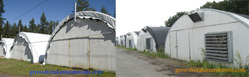
| 127939973 | about 3 years ago | These buildings look like this: http://www.growshiitakemushroom.com/resources/greenhouse+1+copy.jpg It’s a special type of building used for growing mushrooms. I appreciate that ‘mushroom house’ could be confused for a fantasy house for fantasy creatures, that’s a fair point. If you have better naming suggestions for these, please say. They’re not greenhouses though. |
| 127939533 | about 3 years ago | Hi, this change is incorrect and I have reverted it in changeset changeset/127939973. These are buildings for growing mushrooms. They have zero windows, and are kept as dark as possible. They are definitely not greenhouses. I don‘t think there is more appropriate tagging than building=mushroom_house, but if you do, please say. |
| 127680177 | about 3 years ago | That’s good news! Thanks for taking the time to double-check it. I’ve restored the previous access tagging for the path in changeset changeset/127842361. If there are further edits which need to be made around the area after your survey, please go for it :) |
| 127680177 | about 3 years ago | That would be great. Good luck! |
| 127680177 | about 3 years ago | Sorry, I’m quite confused by this. Where’s the factory? On the satellite imagery I only see hospital buildings and a new housing development. There’s a really strong trace on Strava heatmap for this cycle path: https://www.strava.com/heatmap#16.91/-2.98012/53.63338/hot/ride (I’m not local, just interested in this change because its large bounding box made it pop up on my update feed. So I can’t check it in person.) |
| 127571704 | about 3 years ago | I’ve changed it to width=2 in changeset/127771838, since I guess width=0 was an accident. Please say if you disagree! |
| 127769119 | about 3 years ago | Hi, can you please use more descriptive changeset comments than just ‘edit’? Doing so allows others to easily see what’s changed in the map — and why. See osm.wiki/Good_changeset_comments for more information Thanks |
| 127689202 | about 3 years ago | Yeah, because of the legal complexities of access rights in the UK, representing it all in OSM and ID can be a bit tricky at times! There are a few wiki pages which cover specific tagging for the UK, which you might find helpful if you haven‘t found them already:
I’m happy to help out with any questions you might have that aren’t covered by those wiki pages — just drop me a message. Thanks for all your edits around the area recently. You’ve been busy! |
| 127689202 | about 3 years ago | Hiya. I think some of the changes from track/driveway to footpath here aren’t quite tagged right. In particular, changing way/315088626 from a driveway to a footpath loses information about the fact that vehicles can travel along it. Are you aware of the designation= tag which can be used to tag the legal status of a footpath/bridleway, separately from how the appearance/construction/surface of it is tagged? In this case I would have tagged the driveway as:
The access=private sets the default access, and then foot=designated overrides that for foot traffic. designation=public_footpath indicates the legal status of the route. highway=service, service=driveway indicates the type of construction of the route. Does that fit with what’s on the ground here? It seems to match the satellite imagery. :) |
| 127680177 | about 3 years ago | How is the path blocked? Is it permanently blocked and the path has been removed or un-designated? Satellite imagery is showing it as a very large constructed path along the beck. Is that correct? |
| 127571704 | about 3 years ago | Hi, did you mean to set the width of the cycleway to zero? From memory it’s more like 1.5-2m wide along this stretch. Is width=0 supposed to mean something special? Ta :) |
| 127568441 | about 3 years ago | Heya, is this the officially recommended tagging for lime kilns now? What I’ve found on the wiki seems a little unclear, and seems to suggest either historic=archaeological_site, site_type=lime_kiln or man_made=kiln, historic=yes, product=lime instead. |
| 126038502 | over 3 years ago | Hi. I’ve removed this footpath way because it’s not necessary: the road way is already correctly tagged as being a public footpath, and there’s not a physically separate footpath apart from the road (as far as I know — please correct me if I’m wrong). The foot=designated and designation=public_footpath tags on the road mean there’s a footpath right of way along it. See designation=public_footpath for information Thanks for your edits! |
| 125987914 | over 3 years ago | Hi, thanks for contributing to OpenStreetMap! You can add more than one static caravan per edit. Doing so, and providing a descriptive comment for your changeset, will help others in reviewing your work and understanding what changes have been made and why. Please see osm.wiki/Good_changeset_comments Thanks, and happy editing! |
| 125942034 | over 3 years ago | Nice one, thanks! |
| 125942034 | over 3 years ago | Hiya. The relation you edited is for the World Heritage Convention zone for the Lake District, not the national park relation. Would your name changes be better on the national park relation? relation/287917 That‘s what people normally are referring to when they say “the Lake District”. What do you think? |
| 125130766 | over 3 years ago | Since it’s been 2 weeks since your last edit to this golf course, I’ve gone ahead and removed the temporary aligning features in changeset/125651187 |
| 125130766 | over 3 years ago | Hi, are you done with the game-specific edits from this changeset (and changesets 125082608 and 125069516) yet? Thanks |
| 124988080 | over 3 years ago | Great! Hope you enjoy the rest of your time in the area, and good work on the surveying! :) |