dieterdreist's Comments
| Post | When | Comment |
|---|---|---|
| the centre of Berlin | it is forbidden to gather there (“Bannmeile”) |
|
| Psychotherapie Innsbruck | für mich ist so ein Eintrag auch eher Spam als Tagebuch. OSM-Bezug gibt es in dem Text überhaupt keinen. |
|
| the centre of Berlin | Brandenburg GateIt’s interesting you mention Brandenburg Gate. I agree that it is a very good candidate for the current centre of the whole city (as opposed to local centres, Berlin is known for being polycentric by urbanists), for several reasons:
While I am not suggesting to use Breitscheidplatz as the current centre (it’s a centre only for West Berlin), I believe there are at least 3 good candidates for a centre of the whole city: the mentioned Pariser Platz / Brandenburg Gate, Schlossplatz and Alexanderplatz. Here are the arguments for the other 2: Schlossplatz
Alexanderplatz
Both, Alexanderplatz and Schloßplatz, are also very close to political power (the senate of the Land Berlin, Rotes Rathaus, lies in between both). Maybe the Brandenburger Tor (generally Even more?There’s even another central place that might be perceived by many as the centre (and which has been hyped a lot by big money): Potsdamer Platz. (My impression is that this is the centre for the people living close to but not in Berlin, maybe still after Alexanderplatz though). In OSMI have been looking in detail at the history of node pushing of the Berlin place nodes and might post this soon. In summary the first(?) node remained around Schloßplatz (2007: node/20833605, I had originally found this one but am not sure now if it is redacted or I have mistyped the number, deleted in 2012) and another node (28920957) (2007-05-19 - 2008-01-21) remained at the outside in front of Brandenburg gate until it was deleted in V8. Version 1 (2008-01-19) of the current node was moved from Schloßplatz to the square in front of Brandenburg Gate (Platz des 18. März, square on the “outside” (Tiergarten) part) on 2008-01-21 (=deletion of the other place node) and remained there for 60 Versions (2009-08-09) until V62 when it was (correctly IMHO) moved a 100 meters east to Pariser Platz (other side of the gate, inside). It remained there until V70, 2010-03-23, when it was relocated to the crossing of Friedrichstraße and Unter den Linden, where it remains until now. |
|
| the centre of Berlin | Sorry, there’s a typo in the previous comment, it’s of course not palatine but capitoline hill. Here is a model of the first settlement of Rome in archaic times, with the capitoline hill close to the river, from where the development went on. Here the valley around the hill is already covered with houses and the first stone temple is errected on the hill, dedicated to jupiter: the square on the capitoline hill in the 18th century, similar to how it is today:
|
|
| the centre of Berlin | Yes, you can find this historic central junction in many places, although I am not sure if I would associate it with the “centre” in the case of Rome, where the expression of the “central centre” was a couple of main temples on the palatine hill above the forum. In Leipzig, the historic crossing was here, but the current centre IMHO could be in front of the old town hall, or maybe where the locals have put it. Also bridges often play an important role (settlements are often founded along rivers, more particularly at spots where you can cross the river easier than elsewhere). In Berlin, the most important historic bridge was this and as you can see it is quite close to the castle but still distinctively different. After slightly de-routing the ancient merchant’s long distance road which passed in Spandau and Köpenick (older towns than Berlin, now suburbs of Berlin), the merchant main road passed by Cöln on that bridge. This road splits Cöln (the central island, formerly independent town) into a northern part (castle and related buildings, later also museums) and a southern part (Fischerinsel, fisher’s island). In Rome there were also confluencing important merchant roads like Via Salaria (salt road), the Via Latina (Latin Road), and if I recall right an important crossing was close to the eldest bridge, a wooden bridge (Pons Sublicius) which is now lost, close to the tiber island (where you can still observe 2 original ancient Roman bridges). The oldest Roman stone bridge was the nearby Ponte Aemilius from 174 B.C.:
|
|
| The centre of Rome | Yes, clearly it depends on what you want. If it’s for routing, this indication is good as long as you are far away, as soon as you come to a central area you will likely be interested in going to a specific place rather than an abstract centre. I have posted a follow up, in part a reply to your comment, here. |
|
| Generating a list of all the cities in the world with Wikipedia links | You’d better change the live example with something less ressource consuming, if it’s for demonstration purposes only. Why do you think it takes 2 minutes? |
|
| Rendering detailed road areas | I agree with Warin regarding the landuse=grass. Although you can find this frequently, it should really be landuse =highway in most cases. “grass” isn’t a use anyway |
|
| comparing openstreemap-carto to other map styles | @imago: why isn’t mapnik capable of producing the shading? Can you please expand on the details, are you referring to feeding hgv / dem data directly into mapnik, or are you referring to adding preprocessed hillshading raster layers? I have used shading in mapnik 0.7 many years ago (with gdal hillshading script) and it already worked. Doesn’t the final quality depend in the first place on the input raster files of your layer, less so on mapnik? Yes, rendering the hillshading on the fly might be a problem, but blending in preprocessed hillshades in a suitable way (e.g. multiply and screen overlay) isn’t. You can do this for many years. |
|
| Towers and Masts | @TomH while I agree it can be seen like this, (and is actually the case with some tags), it is kind of risky, because most people do not look up definitions, and editors presets present the tags mostly with a one-word description that repeats the tag name, so the actual word used for the tag IS important. It’s almost impossible to establish a tag with a different meaning than the word that is use to describe it. |
|
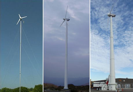
| Towers and Masts | Actually there is more to towers and masts than just looking whether they are freestanding or guyed. There are indeed “guyed towers”. There are several definitions, and there are subtypes. For example a “power tower” is quite different from a man_made=tower. For towers, the key “tower:type” is quite important. Another distinction for example is whether the structure is made for people to access (and maybe remain as opposed to maintenance only). Masts are not buildings (in a technical way of “building”) while towers are (in OSM “building” is also often used for what technically are structures and not buildings). This being said, I do agree that the difference between a mast and a tower is not the size. I would use a criterion like: can you (people) enter the structure, and would also look at freestanding vs. guyed, but accept exceptionally towers to be guyed, and generally masts to also be not guyed, for instance to me these are all masts: http://www.windturbinestar.com/uploads/images/Type%20of%20towers.png This one could be seen as tower: http://media05.myheimat.de/2014/04/26/3077610_web.jpg?1398514834 Basically, accessibility (for more than maintenance) should be the main distinctive criterion. |
|
| Short history of name editing in MAPS.ME | Yes, I agree with Polyglot that keeping name:.. makes sense in all cases, but unfortunately it is not sufficient. We should rather go for something more explicit in the long run, e.g. dropping the “name”-tags all together and always require a language postfix for all names. Additionally there could be a tag to say which is/are the local default names, e.g. ground-language=de or “de;it” etc. Why are name:… tags not sufficient? Example: an place: node/72959652 name=Roma and also name:ace, name:an, name:ast, name:ay, …. are all “Roma”, you can’t tell in which of these languages the name tag is. |
|
| Short history of name editing in MAPS.ME | regarding your list of countries and languages, Germany has a few more languages, but very restricted to small regions, e.g. sorbian (code wen): https://en.m.wikipedia.org/wiki/Sorbian_languages In Italy there’s a bunch of languages in different regions, officially recognized at the same level as Italian is AFAIK only German in Southtyrol, but there are other areas with different languages in use, e.g. in Sardines or in the Aosta area. Generally it seems useful to add both, name and name:local-default language code, because otherwise you can’t tell. In these multilingual areas both names are tagged in the name tag plus both name:language =* In Italy there’s currently discussion and maybe a vote how to deal with officially less recognized but used local names in local languages, e.g. on the sardinian island. |
|
| Super-broad "self-explanatory" tags | I agree with BushmanK. While it is true that the precise meaning of what you can expect labeled under a certain term will vary across regions (for example in a German supermarket or petrol station you can expect to be able to buy cigarettes, in Italy you will never see cigarettes at a supermarket and very rarely at a petrol station (only if there is a tobacco shop integrated)). BUT: the big issue with the midwife proposal is that the description of the tag, although it is very short and doesn’t describe a lot, explicitly excludes some services that are part of the profession in many countries (assisting with giving birth outside of a hospital) and it includes services that are specific to some countries (e.g. advisory services for contraceptives, generally non-pregnancy/birth related services). |
|
| Bing contra Wirklichkeit | sorry, hatte überlesen dass Du die Stelle kennst |
|
| Bing contra Wirklichkeit | Bist Du mal zu der Stelle hingefahren? Nur auf Basis von GPS-Tracks, auch wenn es viele sind, kann man sich nicht 100% sicher sein, es könnte zum einen sein, dass die immer vom selben Gerät mit derselben Korrektur aufgenommen sind (Strecke die ein bestimmter Mapper regelmäßig fährt), oder dass es einen systematischen Fehler durch Reflexion gibt. Wahrscheinlicher ist allerdings ein Problem in Bing, im Detail sind die voller solcher Probleme. |
|
| Why Search and Rescue Organizations Must Map Out Cellular Phone Towers in OpenStreetMap | These stories sound like those sensational tv “documentaries” the US is selling worldwide. Typical fud. If you really need phone coverage in the middle of nowhere you should have a look at satellite phones. With any modern smartphone you hardly can get a day of operation (batterywise), a good paper map(s) should be one of the things you bring on your expedition into the remote areas, a good tent and enough water supplies are also helpful. |
|
| A look into a sample of edits from MAPS.ME contributors | I agree with the analysis of Tomas Straupis, from my experience the edits with really nothing to criticize are more in the 5-10% range, while the rest has more or less severe issues, including changing name tags to localized names, creating duplicate features (for both, node and area features creating duplicate nodes is quite common), creating features without classification (just a name and maybe a tag that says nothing, like tourism=attraction), adding housenumbers to areas that are much bigger than to where the number actually applies, bad positioning of objects (in areas where buildings are mapped and displayed in maps.me you shouldn’t put the features (like hotels and restaurants) right between 2 buildings or in the middle of the road), or bad classification (e.g. B&B added as hotel or hostel), and bad formatting (of phone numbers, website urls, addresses, etc.). Very few of them are actual vandalism, most of them seem to stem from little knowledge how stuff works in OSM and little time dedicated to perform the edit. |
|
| Maps.me is a new evil (instead of Potlatch)? | Nice writeup, BushmanK. I agree with your points. The main difference between Maps.me editor and the ones we’ve seen in the past is the userbase. The amount of edits is unprecedented, and it takes more ressources of the established contributors to fix all the problems that get introduced. I believe maps.me should fix very quickly: - the internationalisation problem (names overwritten or amended with foreign/translated names) - remove whitespace at start and end of values - integrate current data to avoid conflicts - better normalize tags in general (wikipedia, website, phone) Also the measures suggested by Blackbird27 (more community integration, tutorial/text about osm, links to osm wiki) should be enabled. From an Italian perspective, it is also problematic that users are encouraged to add housenumbers to buildings, because they only apply to entrances and buildings have many housenumbers. A very frequent problem I’ve seen lots of times are POIs in the middle of the road, even if the buildings have already been present in OSM. |
|
| Arme OSMF | Ich verstehe ehrlich gesagt nicht ganz, was die Einzelförderung der KnightFoundation an Mapbox in der Aufstellung zu suchen hat. AFAIK hat Mapbox Millionen an Venturekapital erhalten, ist eine gewinnorientierte Firma, und mit der OSMF daher in überhaupt keiner Hinsicht zu vergleichen. Interessanter wäre es evtl., Wikimedia, OKFN und andere freie Wissensprojekte mit der OSMF zu vergleichen. Bei HOT müsste man mal sehen, wofür das Geld ausgegeben wird, ob das nur Personalkosten in der Verwaltung sind, oder auch Auslandseinsätze in Krisengebieten finanziert werden etc. Nur die nackten Zahlen sagen nicht viel. |


