Warin61's Comments
| Post | When | Comment |
|---|---|---|
| print-fold-paste-💢💣💥-paste-fold map | I think any kid would have fun with it … the end product may not be ‘perfect’ … but the object of fun and learning may well have been achieved. Plain sticky tape might be the best way to go for; cheap less mess ease |
|
| The Remains of Phoenix Farm, Gedling | Are not copies of titles to land held by some government department? I know the one here keeps records dating way back … and they are open for public viewing. |
|
| Validating Wikidata tags on OpenStreetMap | At least one more of the location errors is on the Wikidata database. As for “Large red circles mean the distance is greater than 10 kilometers, which indicates a higher error rate” .. errr no not an error rate but a large discrepancy between the two. So .. interesting .. but needs work as detailed by the other comments above.There could be a lot of OSM objects that have Wikidata that are not referenced. That too might be a useful tool for some. |
|
| Rendering detailed road areas | @BushmanK .. yes the whole thing is an example. It may have been better to give a link for the stuff that is left out. In that example other kinds of divider areas have area:highway=traffic_island … from wiki.openstreetmap.org/wiki/Proposed_features/Street_area .. dated 2011. Nothing in the above proposal encompasses the whole area that is used by the highway e.g. the verge … I would think something similar to landuse=railway would be appropriate. |
|
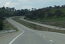
| Rendering detailed road areas | Divider Areas These can be grass… or concrete, rock, shrubs, trees. They are not always grass. https://upload.wikimedia.org/wikipedia/commons/thumb/1/1c/Sydney_-Newcastle_freeway_north_bound_at_Berowra.jpg/270px-Sydney-_Newcastle_freeway_north_bound_at_Berowra.jpg https://upload.wikimedia.org/wikipedia/commons/thumb/e/e8/Jolls_Bridge_on_the_F3Freeway-north_of_Hawkesbury_River%2C_N.S.W..jpg/220px-Jolls_Bridge_on_the_F3_Freeway-_north_of_Hawkesbury_River%2C_N.S.W..jpg https://upload.wikimedia.org/wikipedia/commons/thumb/7/78/Hume_Highway.JPG/220px-Hume_Highway.JPG https://maps.six.nsw.gov.au/arcgis/rest/services/public/NSW_Imagery/MapServer/tile/19/313977/482329 In addition there are ‘runoff areas’ at the side of roads. Sometimes used to provide services such as lighting, water drainage, emergency parking/phone. I thing the best way of tagging these is to use landuse=highway for the areas. The landcover tag can also be used in addition to specify the cover used. |
|
| Transcontinental highway interconnecting Brazil to Germany | Err opps .. 4 years ago. At 30 km/h that would take some time. I’d take it there are not fuel stops along the way either… But as an alternative to flying and shipping your vehicle .. excellent. I think the editors now object to long segments like this on upload. |
|
| Add Country | To be very blunt: You are best placed to do this yourself. OSM is made up of people just like yourself … working away at ‘their’ section of the map to make it better. I hope you will help in your area. |
|
| Owen Cunningham: "South West Coast Path" | i like that… Pity the ‘map’ does not have more detail … I’m certain OSM could have been used! |
|
| Pokemon Go trash | Local to me :- One has clearly state in their changeset comment that they are a Pokemon Go person and that is why they are adding stuff.. fortunately most of them are adding real stuff… some can do with some guidance, true of most new mappers. On the whole, so far, they are ‘good’. A few I have deleted entries .. and they have taken that Ok, and are now adding good stuff rather than making ‘bad’ errors. One looks to have been removed as a user… which is not the way I would go, I’d prefer more communication. Some of them may not realize that OSM is actually used by things otehr than Pokemon Go. So … I think some communication and most of them should come ‘good’. Certainly OSM can use more active mappers here. |
|
| Preamble about me | The advantages of OSM are many. There are some disadvantages too! The Data Uncoordinated .. yes … unpaid individuals all doing their own thing gets you this. However most of them are well intended. First the tagged/encoding itself has grown like topsy, off in all sorts of directions. Secondly the entered data … each mapper has their own mapping desires and so they map that leading to some things well represented while others are sparse if not missing altogether. The Rendering The response here is usually ‘do your own’. Certainly there are a large array of choices available of already rendered maps. Most people initially want something the same as the maps they are used to using … based on habit and present knowledge. |
|
| Irony | Most of my changeset comments have some missspeelin in ‘em. I spend my editorial energy on the tagging, rather than the changeset comments. |
|
| PROJECT 2396. | Good Luck to both the mapping and the malaria actions. Be carefull with the mapping. I have had reports of OSM data in northern Africa being misleading (roads shown don’t exist, roads going through walled compounds). Fortunately at least one of those has said they will be making changes in OSM to make it better .. using their notes of their trip. |
|
| note for clarification | source=survey can mean lost of different things.. to different people. being more verbose is beneficial … source=photographic survey + a GPS point source=photographic survey + bing imagery (old) source=visual survey + bing imagery |
|
| Rail Crossing Warnings Are Sought for Mapping Apps | There are already ‘speed camera warning’ apps … they work from a POI file … so simply a matter of extending the app and extracting the data from OSM. ?? The motivation for the ‘speed camera warning’ app is money and points off your license (where applicable). Motivation for railway crossing .. life, injury and damage. Frequency of ‘being caught’ is higher on the speed cameras, less so on the railway crossings, so the demand of railway crossings is very low … basically most don’t care about getting a warning from their GPS about a railway crossing so any app and/or POI for railway crossing warnings won’t get used. Sorry for my poor respect for my fellow humans. Have a good Xmas. |
|
| An MPG unearthed on Welbeck Avenue | You really need to start writing … Monty Python like.. Humm title? “Assaults on the urban pedestrian photographer” …“The suburban battle ground” … Latest episode “You naughty man, taking photos of my private rubbish! Not for you… Take this” (… beats over head with Tescos shopping). |
|
| Homemade globe | Have he stated mapping yet? Perhaps another one with more and smaller triangles would be a challenge. Certainly smaller triangles would lead to a more rigid structure. However the present one is a good trade off between work and result. The problem with glue would need experimentation with some offcuts first. Probably a specific local glue will be needed for each paper type used. |
|
| No Greater Love Hath Grandkids for their Grandad... | NSW Australia had a map released about 1 year ago. That has been used to enter street names for streets already in OSM (took about 3 months), then to enter boundaries (new and old) for National Parks, State Forests, councils and river and creeks. I have been busy with firstly the missing street names, then the state forests and a few national parks, followed by camp sites, tourist information centers, post offices, waterfalls, some selected creeks and rivers. It takes some time to do all of that .. and not all by me either! So I am now looking at the missing roads - mainly within State Forests, access ones to ‘my’ waterfalls, some National Parks. Of course the data entry is not perfect, I have found a few of my ‘errors’ and corrected them for the most part. I have found a few others too and corrected them. Road names have been tricky - entered from the road name at one end .. only to find the other end has a different name. Some boundaries have been combined with rivers .. when they are actually separate. Some creeks don’t flow into another water course. One creek flows from both ends towards the middle. So some detected ‘errors’ are not errors. That map has been very helpfull particularly in wooded areas where satellite views don’t help. It will be helpfull for house numbers too as those are shown on the map too .. but there is a lot to do with it yet. |
|
| No Greater Love Hath Grandkids for their Grandad... | My definition of “English rain’ ; so light that it sits in the air and lets you walk into to it. I do prefer tropical rain; thrown down at maximum velocity and all at once. Gets it over and done with. Australian for ‘khazis’; dunny. { shortened form of dunnakin, from dannaken, danna = dung + ken = place} Usually with the back lane for the ‘night soil man’ weekly visits. I am still finding roads and tracks to put on the map. So homes are a long way down my list of things to do. |
|
| Does this look like a theme park to you? | Arr .. found my comment for showground under recreation_ground talk … “A ‘showground’ can be tagged landuse=recreation_ground with recreation_ground=showground” Cannot say I stick by what I said, but there you are. |
|
| World Map in Dymaxion Projection (print-cut-fold-and-glue) | Nice! |