Viajero Perdido's Comments
| Changeset | When | Comment |
|---|---|---|
| 127271702 | about 3 years ago | Forgot to mention: the relation also needs type=multipolygon. Example: relation/6723248 |
| 127271702 | about 3 years ago | If I can elaborate... Create a relation, containing all 5 ponds as outer members. Tags (name etc.) go on relation only, not on member ways (remove those), so tags are recorded only once, and rendered only once. Add the two islets as inner members, and they'll un-disappear. And I'd double-check spelling of that islet. Cheers. |
| 127106357 | about 3 years ago | Oops. Part of previous changeset (the "simplify" stuff) got mixed in with this one, probably because the server conked out partway during the previous upload. It all seems fine though. |
| 123184298 | about 3 years ago | It was already mapped.
|
| 113245845 | about 3 years ago | Look closely. |
| 117749218 | over 3 years ago | PS, OSM supports multiple names, useful for searching. Eg old_name, alt_name, official_name, etc. (There's no official name according to CanVec, BTW). |
| 117749218 | over 3 years ago | Hi. Thank you for clarifying. Had you included this info when you made the change (source), I'd have left it alone. Given that the previous name in OSM was Japanese-sounding (also unattributed), it was easy to assume this renaming was a quick derogatory shot. I already removed the name (since no attribution was given for any of the names it's had), but you're welcome to add it again, with attribution. That'll discourage others from changing it. I won't get involved (further, argh) in name wars... Cheers. |
| 117749218 | over 3 years ago | Hi. You changed a peak name to "Jap Mountain". Where does this name come from? |
| 116520506 | over 3 years ago | What is the name:: suffix for that? If doing multiple languages, you'd want:
|
| 118037593 | almost 4 years ago | Hi hoserab.
|
| 114335082 | almost 4 years ago | I fixed it. |
| 114335082 | about 4 years ago | Hi JetCat. You deleted two multipolygon relations, effectively removing a large area of wood (1) and forest (1). Please revert this changeset, or rebuild the polygons manually. |
| 109601485 | about 4 years ago | No biggie. I can put it back. It's not like any maps actually render it... until it's built. :) |
| 109601485 | about 4 years ago | Hi. Any reason for deleting aerialway=proposed? Glitch? |
| 112795462 | about 4 years ago | Hi sonik90. Assuming that's a typical mountaineering route, may I suggest adding "trail_visibility=no" (or as appropriate) to the path? Some maps will render that as, say, a dotted line, rather than something more substantial. |
| 102663030 | about 4 years ago | Thanks for catching the Rig Street closure at the bridge. I'd heard something about that, and decided to trust the auto-router when it said, go another way. Saved me some driving, and I found a nice camping spot on the detour. :) |
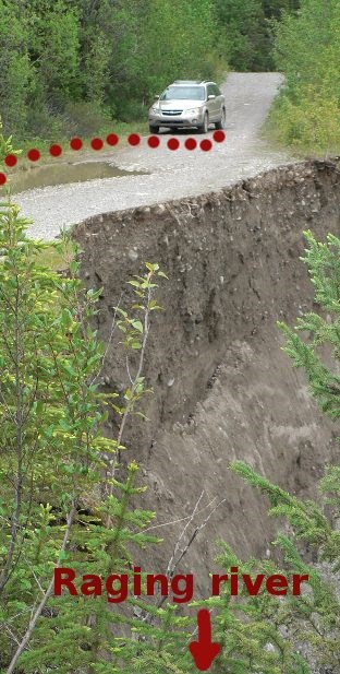
| 108500127 | about 4 years ago | Thanks. Sorry, I get grumpy sometimes if I find my work has undone. Here's what it looked like before it crumbled away some more.
|
| 108500127 | about 4 years ago | Wrong. The road was split by the river, a washout not worth the trouble to repair. I was there. You weren't. |
| 110528931 | over 4 years ago | Version 5 looked the most correct. man_made=pier, waterway=fuel. (I never knew about the latter.) |
| 110528931 | over 4 years ago | No. Try man_made=pier instead.
|