PlaneMad's Comments
| Post | When | Comment |
|---|---|---|
| The invalid areas of the map | Updating the map is a manual process from the dump Jochen is generating everyday. Have not thought about an update cycle, but can do once a week till there is demand to do it more often. |
|
| The invalid areas of the map | JBacc1: Just tested on Chrome and Safari, can you open a ticket with any console errors you are seeing here: https://github.com/osmlab/fixing-polygons-in-osm/issues Or maybe a cache issues? I updated the map yesterday to fix this. |
|
| The invalid areas of the map | Mateusz Konieczny: Thats right, it looks like theres always going to be cases where it would be impossible to predict what was right without a deeper investigation. Have made an edit in my post. JBacc1: If you click on any feature you will get an |
|
| A tyro's experience with OSM | Great to hear your positive experience, welcome to OpenStreetMap! Nice work in your hometown, if you know the name of the streets you should add them as well. |
|
| Gotta love people who don't look at the satillte imagery and ajacent ways and think that turn lanes need to be fixed. :/ | This looks like an error in how empty turn lanes were detected and I just documented it on osmlint for correction. The context for the cleanup was the occurrence of tags like One of those two checks seems to have flagged such cases in error, and it was a mistake on the mapper part to not highlight the inconsistency as it was spotted. Is this a common pattern on only two lane roads, or does such marking appear on larger highways as well? Weighing the option to either revert all the changes or just those that match a certain tag combination. |
|
| Get Set Go With Basaveshwaranagar Mapping Party! | Such an amazing writeup! This brings the total count of trees mapped in the city to 2259. Do you tag the tree stumps as trees as well? I’m always confused when a plant becomes a tree and now my benchmark is if its 1 building floor high, its a tree! |
|
| Is that a country? | Interestingly the Siachen Glacier In the Himalayas has a similar history of lying in an undemarcated zone that is claimed by India and Pakistan. The situation changed in 1998 after a war broke out between the two and the Indian army finally took control of the highest battlefield on earth. |
|
| Is that a country? | Thanks SomeoneElse for the backstory. Always fascinating to read a disputed border story :) |
|
| 1000,000 points on the map. | Beers to you! |
|
| HOTOSM recognition by the President of Mexico in Internet Day 2016 | Amazing, this is a great example of how valuable projects like HOTOSM are for developing nations like India where millions of citizens are vulnerable to disasters like cyclones and flooding. Nice work all! |
|
| What's up with the Rann of Kutch? | Having set foot in the Rann, its essentially a very large mudflat crusted with an inch of salt, atleast when its not submerged. There is a very clear boundary where land ends and the saltmarsh begins, but its unclear where the marsh ends and the coastline begins.
Have tried cleaning up this area before, but it just seemed unclear how to proceed. Nobody has brought it up for discussion in the Indian community either. Maps in India usually depict it like this:
|
|
| Hadjer Lamis, Chad - Tracing guide (villages and buildings) | Btw, great post. its interesting how humans so far away geographically evolve very similiar habitations. |
|
| Hadjer Lamis, Chad - Tracing guide (villages and buildings) | This is very similar to the structure of villages in India near the deserts in the northwest. The My suggestions for tags is to use |
|
| Linting the open map of the world | SomeoneElse, the ground mapper is always the most important part of the process. The objective with tools like these is to allow ground mappers to easily modify and run an analysis for their areas of interest and fix it themselves. These are still early days of trials and testing the output and its great to detect such issues early on rather than later. What you highlight is an issue worth solving, there are many mappers in the world who are interested in data ‘gardening’ of areas outside where they live, and we need to see how we can build tools to support such needs. Whats a reliable definition of what constitutes an area that has a ‘reasonable concentration of mappers’? Checking the history of each way or visual check of completeness cannot always work. Maybe evaluating the average freshness for the data in an area? It might then be possible to easily distinguish which are areas with active communities that one can get in touch with for ground support or alternatively such cleanup tasks could ignore these areas altogether. |
|
| Mapbox's probably fragmentary "Tracking conversations" tool | ^ sorry, that came from me, left my new LA buildings account logged in.. |
|
| Thrissur Kole Wetland | Fantastic work Manoj!
|
|
| Making a multilingual map of India using OpenStreetMap data | Can’t really recommend one over the other since I have not tried generating vector tiles myself. My guess is that the standard osm2pgsql/postgres setup should work. |
|
| Making a multilingual map of India using OpenStreetMap data | And yet another is to use the OSM QA tiles that are updated daily, although these do not yet support relations. |
|
| Making a multilingual map of India using OpenStreetMap data | Another workflow is to use minjur to convert OSM data into geojson and tippecanoe for conversion into vector tiles. |
|
| Making a multilingual map of India using OpenStreetMap data | pnorman, the first step is to create vector tiles of the data you want to render. One can do this from a regular mapnik source using https://github.com/mapbox/tilelive-bridge . Next is to use a JS library like https://www.mapbox.com/mapbox-gl-js/api/ to request vector tiles and render them on the client side using a GL stylesheet https://www.mapbox.com/mapbox-gl-style-spec/ which will give the same results. The hard lift in the process is to manage vector tiles and keep them in sync with OSM data. This is essentially what is simplified by using Mapbox hosted vector tiles. |
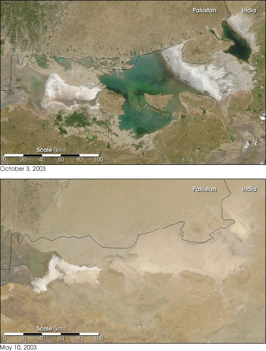 The Rann during monsoon and when its dry.
