MikeN's Comments
| Changeset | When | Comment |
|---|---|---|
| 104154354 | over 4 years ago | The top Bing search result leads to a parked web site. The old "Main street inn" Facebook page was last updated in 2018. https://www.facebook.com/Main-Street-Inn-54515823197 The Highlander Mountain House began in 2020 https://www.facebook.com/TheRuffedGrouse |
| 104154354 | over 4 years ago | Hi, why was the current Highlander Hotel overwritten with the older Main Street Inn name which is closed now? Your information source is out of date. |
| 98017373 | over 4 years ago | Hi, why were these streets set to private? There are no gates shown on Bing Street view. There is a "private subdivision" sign, but the sign does not say "private, keep out". Most subdivisions could be described as private. |
| 103813766 | over 4 years ago | Yes, the new Popeyes was built in the same location as the old building that was torn down. The old building was a reasonable approximation for the new building until new imagery is available. Someone had already added the new driveways for the new configuration which don't match the old driveways. Mapillary - new: https://www.mapillary.com/app/?lat=34.776000402528275&lng=-82.30878573552894&z=17&pKey=0n5efscjoYSAahP82UuiPC&focus=photo&x=0.7093908239480355&y=0.6098956962635605&zoom=1.195219123505976 Old: https://www.mapillary.com/app/?lat=34.77600950426481&lng=-82.30879636724463&z=17&pKey=FpfZn2o1Fl79FIHNsxeTbh&focus=photo&x=0.6721109452384936&y=0.5310385056099296&zoom=0.7865956405545973 |
| 103842465 | over 4 years ago | Hi, thank you for this edit. Everything is good so far but there are 2 things that can be improved: 1. Add building=yes tag since it's a structure that you can walk into. 2. Press the Q button to square the corners since it's a rectangular building. |
| 103813766 | over 4 years ago | Hi, Why was the new Popeyes restaurant and the driveways around it removed? way/571503782/history Why was the new building at way/907190790/history removed? |
| 77129003 | over 4 years ago | surface=paved gives assurance to road bikers that they will not be riding on gravel. And being non-specific about the type of material leaves it open for later mappers who know the specific material type to update. |
| 98800841 | over 4 years ago | Hi, the way at way/913785031#map=19/34.80470/-82.28467 has magically reappeared as expected. It is very helpful to retain ways tagged with demolished:highway until the default Bing imagery catches up. |
| 101492031 | almost 5 years ago | Hi, Why was this changed to Richmond but is really in another city? Why was address and extended tagging information removed? |
| 101047454 | almost 5 years ago | Thanks for the explanation. I reverted because some of the roads were crossing without junctions - that won't help navigation either. The original OSM editor who created these roads under construction set them as their final configuration, rather than reflecting their current state. I have updated to show something closer to what I believe to be the current state, based on the Maxar Premium imagery dated summer 2020. It may still be wrong - feel free to correct for current GPS traces. |
| 101047454 | almost 5 years ago | Hi, This area is undergoing construction and does not match the latest imagery. Please use meaningful changeset comments - your name does not help other mappers understand what you are doing. osm.wiki/Good_changeset_comments |
| 100233976 | almost 5 years ago | Hi, Great work in Greenwood! These buildings with inner courtyards are the trickiest parts to get right. There's still a technical problem in that the outer parts of the multipolygons share ways, which is not allowed - therefore might not render correctly or at all. I don't know the easy way to get it back in ID from where it is, but starting over, I see First Presbyterian as one outer way and 3 inner ways. If you draw all 3 that way, then select the "Merge" function from the right click menu, it should create a good multipolygon. |
| 100122344 | almost 5 years ago | Hi, Why did you delete so many residential roads and buildings and destroy the geometry of Cleghorn Mill Road? |
| 99933079 | almost 5 years ago | Hi fiscal,
|
| 99762594 | almost 5 years ago | Hi, Welcome to OSM! By removing the leisure=park tag, you removed Keowee Park from the map. I have restored it by adding the protect_class tag. |
| 94402350 | almost 5 years ago | Please correct your program BusLanes, as this is the second time it has made this same mistake. |
| 94402350 | almost 5 years ago | Hi, the roads on the upper deck are not bus lanes, but just a standard parking deck. I have corrected this. |
| 98800841 | almost 5 years ago | That is the trees in the neighboring parcel. The point is that a construction zone shouldn't be deleted until it is obvious that it is finished. And often they shouldn't be deleted but moved to the next step in the OSM lifecycle - such as residential, commercial, or retail. |
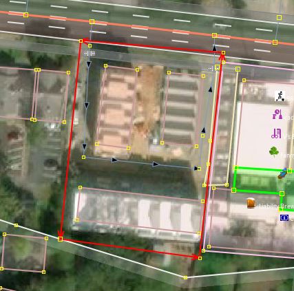
| 98800841 | almost 5 years ago | Not sure where you're looking, but there's only dirt and construction equipment pictured in the construction zone. |
| 98800841 | almost 5 years ago | The construction zone was the red line in the linked photo. Any shadows are from neighboring trees. It's difficult to declare construction complete from only aerial imagery. Maxar Premium (latest): https://greenvilleopenmap.info/oneTwentyOne.JPG |