Geodata references
Posted by John O'Hanley on 22 February 2020 in English. Last updated on 24 February 2020.The Province has excellent resources online.
PEI National Road Network PEINRN Up to date, includes all the data you’d ever need.
Place names in Canada No type info, or population info! No indication of the precision of the lat/long. English and French.
Feature names in Canada. Not bad. 1869 items for PEI. Water and towns. Dowside: no population number, BUT it has categories that can do the same thing: locality, community, town, city.
Lakes and rivers- National Hydro Network - NHN - GeoBase Series
Natural Earth - motherlode of global mapping data. Seems to be of high quality. 1:10000 is their most-detailed recommended scale.
Global place names with pop. About 7300 places. Small towns missing.
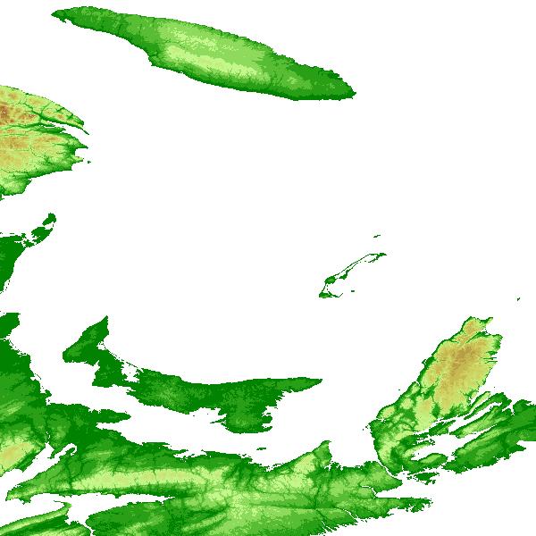
Global elevation data - the free versions of this data are usually based on data from NASA called SRTM. You can download it here. That original data set has holes, that can be filled by interpolating. The CGIAR data set interpolates. More info here. The resolution comes in 2 flavours, 90m and 30m. Here’s an example of it being used for shading. It’s certainly fine for indicating general elevation - example. Reference for mapnik.
It’s likely best to use transparency, and the alpha-channel, to render the hillshading.
Global elevation shading, $1000US
Also see OpenDEM.
Global Bathymetry - GEBCO may be low res, hard to say. Also see OpenDEM.
Bathymetry of the Gulf of St. Lawrence?
Note that large municipalities (including Charlottetown) handle their own civic addressing.There’s location data for each address. The exact point seems to line up with the driveway of a house, not the centroid of the house. This makes sense, for access by emergency services. The nominal precision is about 1 metre. Example:
91 PRINCE CHARLES DR CHARLOTTETOWN QUN 46.23739 -63.14737
Provincial road atlas 2014 Quite nice, 108 pages, printable PDF. Not geodata, but a finished product. 11 x 17 (ledger), 2-sided, color: would cost ~100$ to print at Staples. Possible new edition in 2020, showing the new highway in Cornwall.
Discussion