InfiNorth's Notes
Notes submitted or commented on by InfiNorth
| Id | Creator | Description | Created at | Last changed | |
|---|---|---|---|---|---|
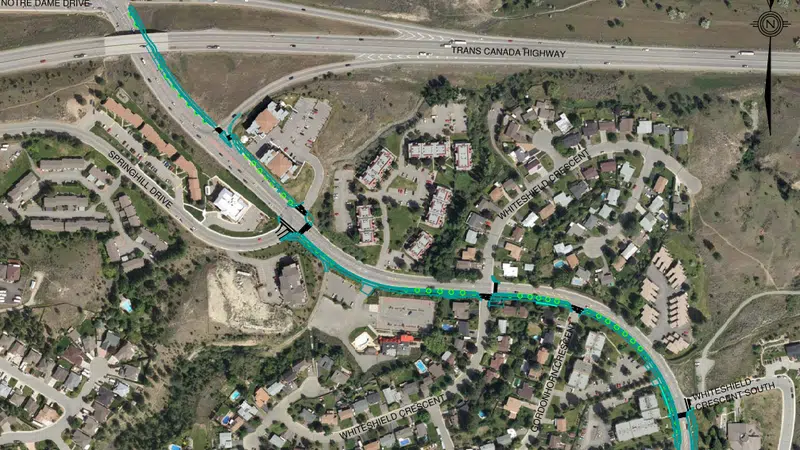
| 4268566 | Several nearby bike connections are shown incorrectly. 1138519886, 999222337, 999222338 should be foot paths only. They are standard sidewalks, the wider multi-use pathway that allows bikes runs along the east side of Summit Dr in this section. Multi-use pathway visible in blue in linked image: |
||||
| 4289431 | Springhill Drive now has a curbside bike lane in both directions between Sedona Drive and Summit Drive. Visible in Google Maps street and satellite views. |
||||
| 4513747 | This is a separated cycling lane. |
||||
| 4322638 | smithkm | Tagging Bastion Square as one big pedestrian area obscures the presence of many stairs and ramps connecting different parts of the square. |
|||
| 4059276 | Mateusz Konieczny |
Is bicycle_parking=anchors really correct here? In case that it is a correct tagging - can you make photo and upload it to Wikimedia Commons or make it available on open license in other way? I want to add it to OSM Wiki documentation and so far I was unable to find even single actually correct bicycle_parking=anchors |
|||
| 4289619 | smithkm | This section of Cedar Hell Cross Road is taged as 30 km/hr, but https://www.saanich.ca/assets/Local~Government/Documents/Bylaws~and~Policies/streets-and-traffic-regulation-bylaw-2002-no-8382.pdf says it should be 40, need to check signs to confirm |
|||
| 4520283 | InfiNorth | Construction underway here - new multi-unit condo/townhome |
|||
| 4266776 | smithkm | Need to ground truth the bays and their relationships to routes. The map on the BC Transit website shows no Bay G and none on the east side of Government. |
|||
| 4297907 | smithkm | https://www.saanich.ca/assets/Local~Government/Documents/Engineering/Cycling-%20Network.pdf shows viewmont and Mapleton as shared bikeways. |
|||
| 4522624 | InfiNorth | Mann Avenue is not shown by any sources (including 2023 aerial imagery and 2024 bike network map https://www.saanich.ca/assets/Local~Government/Documents/Engineering/Cycling-%20Network.pdf) to have any bike infrastructure. This needs to be reviewed. |