OpenStreetMap logo OpenStreetMap

Harry Wood's Diary

Recent diary entries

Pakistan Remote mapping Workshop

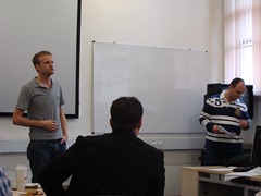
Posted by Harry Wood on 28 October 2010 in English. Last updated on 29 March 2011.

We had a Pakistan Remote mapping Workshop last Thursday. For quite a while now I've pondered variations on the format of a normal mapping evening/pub meet-ups, and I was thinking about this event in those terms, but this was no minor variation. It turned into something totally different. All the usual group of people didn't sign up. I assume this was partly because they're not that excited by the idea of remote mapping, partly because they're not that excited about journeying to that rather awkward corner of North East London, but mainly because they failed to sign up in time. The event was quite suddenly over-subscribed with all 18 places (the capacity of the venue) taken by people keen to learn about how to help map Pakistan as part of humanitarian OpenStreetMap work. All of them were new to OpenStreetMap.

20102010348

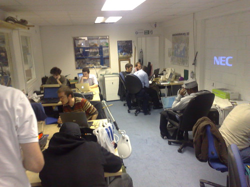
The popularity of the event was thanks to Spike, who was the chief organiser. He arranged the London Hackspace venue, and got lots of interest via Crisis Camp channels.

See full entry

Location: De Beauvoir Town, Dalston, London Borough of Hackney, Greater London, England, N1 4DA, United Kingdom

Homage to Ollie and #geomob

Posted by Harry Wood on 26 October 2010 in English.

I managed to write a diary entry about the bloomsbury meet-up without including this cheesey photo of Ollie. He probably thought he'd got away with it, but no! This diary entry is dedicated to Ollie O'Brien :-)

New Nike grid OpenStreetMap map graphics

Here's Ollie in a Nike Grid T-Shirt, and with a Nike Grid poster, featuring OSM maps! Properly attributed this time (or be it the smallest attribution ever). Nike Grid (nikegrid.com) is an game/sport thing involving running around between phone boxes. It's done in a funked up urban nike kind of way, but it resembles orienteering.

...which is one of Ollie's passions. In fact he is the creator of OpenOrienteeringMap, a custom rendering of OpenStreetMap in the funny pumpkin coloured style that orienteers go for.

See full entry

Bloomsbury mapping party

Posted by Harry Wood on 25 October 2010 in English.

The next London mapping party is fast approaching (Thursday) but I still have stories to tell from the previous two mapping parties!

A couple of weeks ago we met at a pub of Matt's choosing. "The Enterprise" was very pleasant, but I was disappointed that the staff were not in uniform, and there were no turbo-lifts, warp-drives, or holo-decks to be seen.

This pub was in the Bloomsbury area, and I took the opportunity to fill in one of the most annoying building outline gaps just south of the British museum. Interesting area. Quite a few missing shop POIs which I didn't get time for, but I just OpenStreetBugged them.

Steve Chilton also took up the building challenge, and maybe a few other people did too, so we've sort of connected the patches to form a large area that is looking much more filled in now. See the map of bloomsbury. In fact looking at the whole of London, things are looking vaguely more balanced now. There are still some annoying gappy bits, but not nearly so many.

Back aboard the enterprise...

See full entry

Location: Holborn, London Borough of Camden, Greater London, England, WC1R 5AH, United Kingdom

UCL masters student mapping party

Posted by Harry Wood on 13 October 2010 in English. Last updated on 24 October 2010.

The UCL masters student mapping party took place a couple of weeks ago (another thing from my blog backlog) We showed a class full of students how to do mapping. These were masters students just starting on a new geomatics course. The idea was put forward by Muki Hacklay and organised by Thomas Koukoletsos in consultation with a few OSMers: myself, Dan Karran, and Sam Larsen.

We started with a little "lecture" about OpenStreetMap. Reminiscent of my student days, I got there a bit late, and planned to go sit at the back, but as it turned out Thomas quickly handed over to me to explain OpenStreetMap. My unprepared explanation followed the lines of various talks I've been giving, at least at the start, but for the rest of the day I remembered other things I should've said.

UCL student mapping party

See full entry

Waterloo and South Bank mapping party

Posted by Harry Wood on 12 October 2010 in English.

It's been almost a month since our last normal London mapping evening in Waterloo/South Bank area. We were back in the good old Mulberry Bush, so nothing unusual at all...

Well that's not quite true. I found it quite an interesting meet-up because we had along two people who were new to mapping. I arranged to meed David beforehand, and took him on a quick walk around Gabriel's Wharf and the park alongside. Meanwhile Clare seemed to manage very well on her own, turning up at the pub with scribbled-upon printout, looking like a pro-mapper!

I got out my laptop and gave them an demonstration of JOSM editing. It had to be JOSM because I was without internet connection. I had cunningly saved the downloaded area earlier. I even had a saved yahoo imagery file but the offline file feature of the WMSPlugin seems to be a bit buggy. Anyway, I secretly prefer teaching JOSM to new mappers. I find it more usable, so why wouldn't anyone else? Speaking of which I've got a new screencast tutorial I have to finish editing some time (in the meantime if you've never tried JOSM, do it!)

Anyway I managed to not spill beer on my laptop, and both of these people seemed to get the hang of JOSM to the extent that they have since inputted more data (in addition to the pub changes I saved) More mappers. That's what we like! I should've got some photos while this interesting stuff was happening, but I'm afraid I only got the camera out later. So...

Here's the usual bunch sitting around getting drunk:

See full entry

Location: South Bank, Waterloo, London Borough of Lambeth, Greater London, England, SE1 9PZ, United Kingdom

blog backlog

Posted by Harry Wood on 2 October 2010 in English. Last updated on 15 October 2010.

I've got a bit of blog backlog at the moment. There's photos of these things on flickr already:

  • For completeness sake I should really have a diary entry about the Waterloo and South Bank mapping meet-up we had two weeks ago (cake). It was a fairly interesting meet-up too.

  • I went to Shanghai to talk about OpenStreetMap. Actually I already blogged photos from this but haven't said much about why I was there, or things following on from it.

  • Immediately following that we had the UCL Masters Student mapping party. Essentially a bunch of OSMers showed a bunch of students how to do mapping over two days.

  • In parallel to all this, I've been guest blogging alongside Gregory on the Hodder Education - Geography blog. Some posts to appear there still, and one more post to write still!


It's been a busy few weeks, but I'm also looking ahead to a few upcoming events listed here

In my last post about the mapping Party in Holborn, I forgot to mention one thing. The mapping! I was mapping some building details again (it's a priority area). Here's my paper mapping. This is corrections I was making to building outlines which I had sketched in earlier from Yahoo! imagery.

If there's one thing more satisfying than seeing your work appear on the map, it's seeing several people's work appearing on the map after a mapping party. I'm still in the habit of uploading stuff and then forgetting about it, ingrained back in the day when you used to have to wait for the weekly rendering cycle to see your changes. So I hadn't bothered to look back here until just recently. The bit of building detail I was working on is here, and you can see other people's stuff appearing alongside. In particular there's User:Kachkaev's details of Red Lion square.

See full entry

Last Tuesday's meet-up. Рыбинск. Boris bikes. etc.

Posted by Harry Wood on 5 September 2010 in English. Last updated on 11 September 2010.

On Tuesday we had a London mapping evening which, coming straight after the bank holiday, seemed to take everyone by surprise. Perhaps this was because I made the cake diagram and sign up list not very far in advance, so I'll do better next time:

Sign up now for the Waterloo / South bank mapping party. Cake diagram available already!

That's on Wednesday 15th. Ages away! But if you are approximately possibly maybe able to come, add you name to the list, and this will spur more people to join in. I'll try to put the message out to various event listings and other organisations, but as ever, if you have ideas for this please go ahead and help promote the meet-up.

On Tuesday I think we had 7 of us including a couple of new people. I was chatting to User:Kachkaev...

OpenStreetMap Holborn Meet-up

See full entry

Location: Holborn, London Borough of Camden, Greater London, England, WC1R 5AH, United Kingdom

On Friday (this Friday!) it's the OpenStreetMap 6th Anniversary Birthday party!

We'll be celebrating in London, and as I said before, the idea is to make this a BIG event, so if you've wondered whether to bother travelling into London for an OpenStreetMap event, travel in for this one! (and help make sure such people know about it)

London too far away? Well we're partying in other places around the world. It's great to see events set up in Hamburg, Amsterdam, and Toronto. If none of those are near you either, well how about setting up another OpenStreetMap party in your neck of the woods? There's still time!

It feels like a while since we've had a get together. I probably would've arranged a mapping evening last week. That would have sandwiched nicely between the anniversary party (did I mention it's this Friday?), and my BBQ meat-up of two weeks ago. ...but then I was away last week with work.

See full entry

BBQ bash last weekend. OSM anniversary Fri 20th

Posted by Harry Wood on 4 August 2010 in English. Last updated on 20 August 2010.

I'm pretty pleased at how the BBQ turned out on Saturday. I woke up to some of the most miserable weather I've seen in a long time. Those who did a bit of mapping (Gregory & Derick) may have caught the tail end of that, but by midday the sun was out!

Admittedly that was a fairly short gap in the clouds, but good enough for sitting outside. No need to resort to any desperate indoor activities such as jigsaw. Well... I did get the jigsaw out later on (THE jigsaw) but we didn't really do it much. We'll have to have a more concerted jigsawing effort some other time.

Much meat was consumed, and given that I spent the whole of Sunday feeling rough, I guess we probably drank a fair bit too. We also had a 31 shaped cake aswell as bicycle bashed Shaun cake, and Shaun bread buns. mmmmm...

See full entry

Charing Cross Mapping Evening

Posted by Harry Wood on 26 July 2010 in English. Last updated on 4 July 2012.

Rather too soon after all the excitement of State Of The Map, we had a London mapping evening in Charing Cross. No time to take a breather. It was back to the mapping.

Well for me at least. I wanted to try and plug another gap in the buildings, so the cake diagram was around Charing Cross / Covent Garden area, and I filled in a chunk of buildings there:

The Covent Garden area is POI central, and although we have quite a few things mapped, it became clear to me that Osmarender should be a whole lot more cluttered. There's a bazillion missing restaurants and bars. All we need is a decent pub in the area. That unfortunately is a bit of a problem. It's generally way too crowded and touristy for mapping meet-up pubs. Tom had a suggestion though. The Theodore Bullfrog was pretty good

In the pub Grant brought along an extra South African, and together they hatched a plot to release some out of copyright maps of South Africa. kiff bru! (?)

See full entry

Location: Westminster, Millbank, City of Westminster, Greater London, England, SW1P 3JX, United Kingdom

State Of The Map 2010 in Girona

Posted by Harry Wood on 21 July 2010 in English. Last updated on 18 August 2010.

Last week I had a few sleepless nights because I was buzzing with OpenStreetMap thoughts and when I did sleep it was with mappy dreams. That's the SOTM effect. State Of The Map 2010 in Girona was another truly spectacular mapfest. A meeting of map professionals and map unprofessionals with a load of paella and sangria on top. Bake for three days.

SotM Girona
The weather was pretty sweltering even at 11p.m. when I arrived at the pre-SotM drinks. I had the pleasure of sharing an apartment with Henk and Ivan, the chief organisers. We headed back pretty late, and they then launched into a session of printing badges for attendees (including all the last minute signups) Hard work organising something like this!

See full entry

Location: Eixample, Girona, Gironès, Girona, Catalonia, Spain

Belsize Park mapping party

Posted by Harry Wood on 7 July 2010 in English.

At last Wednesday's London Summer mapping party we ventured out of zone 1 all the way up to Belsize Park. It's not very far out of the centre of London, but one of those places which is just far enough that people tend to have not heard of it (although most people have heard of Hampstead) I decided it was time to get off our asses and map somewhere a bit more challenging to get to. This always means fewer people coming along, but it can be worth it for some more satisfying mapping. We'll have to go out as far as Heathrow to find a more raw mapping experience these days (noname streets) but Belsize Park had some juicy unmapped pockets of POIs. I was also finding some little service roads and gated-off private roads to add.

The Sir Richard Steele pub was rather nice. Well the ceiling was good certainly.

See full entry

Location: Primrose Hill, Chalk Farm, London Borough of Camden, Greater London, England, NW1 8XN, United Kingdom

Government Technical Workshop

Posted by Harry Wood on 30 June 2010 in English.

We've just had our OpenStreetMap Government Technical Workshop and hack weekend. We had Gareth Baker and Sandy Pacek from the Greater London Authority, Scott Day from London Borough of Southwark, and Alisdair Maclean from London Borough of Brent, all gathered in the spectacular London City Hall building along with a whole bunch of OpenStreetMap hackers.

See full entry

Location: Bermondsey Village, The Borough, London Borough of Southwark, Greater London, England, SE1 3UB, United Kingdom

I've got behind on a few things lately, there's some upcoming events which have crept up on me like a ninjapanthersnake. Damn those event ninjapanthersnakes!

The OpenStreetMap Government Technical Workshop and hack weekend is this coming weekend (TOMORROW), but sign-up is now closed. If you want to come along now I'll have to ask if we can add your name to the building entry list, which maybe alright, or it may be awkward. I'm not sure.

I would still like it if we got some last minute attendance requests from some of our target government GIS type people, so if you know anyone who knows anyone, tell them to give me a call. Here's a pretty PDF you could send them.

See full entry

A couple of weeks ago the London summer mapping parties came to Soho.

Back to Soho I should say. Perhaps not the most imaginative choice of location, but as my cake diagram hinted fairly heavily, I'm still hoping to fill in those building gaps (see coverage blobs). We did pretty well with that around Fleet Street, but I think people are uninspired by Soho's buildings. They're a bit more of a standard city block layout. Not very exciting, although I did find some alleyways which needed rearranging in my slice.

That was before heading to our old favourite pub The Blue Posts. I found everyone sitting outside. How very European. In (and outside) the pub we talked about...

Augmented reality smartphone apps such as Layar, and how they generally suck because we want mini Darth Vaders dammit! (was that the reason they suck? or did I just make that up?)

Every branch of the bank Abbey recently changed name to "Santander". That's a lot of https://wiki.openstreetmap.org/wiki/Tag:amenity=bank nodes which need to change across the UK (and elsewhere in europe?) But we wont mention the dirty three letter B word.

Google wifi data gathering was hot news two weeks ago. Evil or not? I don't know, but if I was going to the trouble of driving a along every road. I'd definitely make sure I was gathering more data rather than less. Their mistake was letting anyone find out about it :-)

See full entry

Location: East Marylebone, Mayfair, City of Westminster, Greater London, England, W1T 3PP, United Kingdom

Fleet Street last time

Posted by Harry Wood on 8 June 2010 in English. Last updated on 10 June 2010.

The next London evening mapping session & pub is on Wednesday.

Last time we were over in Fleet Street. As it was almost two weeks ago now we've all input our data, and the result looks great. Much less of an ugly gap in building coverage there. That particular patch was actually the centre of the cake for our massive mapping party back in January 2007, based at the MultiMap offices. Since then it was considered to be one the best mapped parts of London for a long time, until we started on the building outlines and super-POI details. Then it became an ugly gap because the buildings are hideously complicated in this area. Old buildings meeting new buildings at funny angles, with narrow allyways and pedestrian tunnels everywhere. Very difficult to see clearly in yahoo, and the building outlines are not particularly easy to map on-the-ground either. This is particularly true of my slice just to West of the pub.

See full entry

Location: Blackfriars, City of London, Greater London, England, EC4V 4EG, United Kingdom

Elephant mapping in Notting Hill

Posted by Harry Wood on 24 May 2010 in English. Last updated on 8 June 2010.

Before you read any further... Tomorrow night we're mapping around Fleet Street Sign up! sign up!

A couple of weeks ago we had a evening pub meet-up and mapping session in Notting Hill. Matt picked the pub, and gregory drew the cake diagram. So that was great. I got a bit of an organising holiday. If anyone fancies doing either of those things in future, please let me know... or just do it! Other tasks include setting up the wiki information, setting up listings on upcoming.org and other places, and doing a fun little diary entry about it afterwards. But wait! I forgot to do the fun little diary entry! OK here goes...

The weather was rather pleasant, and I'd somewhat cheekily opted to map a slice which was already thoroughly mapped, just because I fancied going to take a look at Holland Park. I'd never been there before. So had a quick peek:

See full entry

Location: Westbourne Green, Bayswater, London, Greater London, England, W2 5EA, United Kingdom

London blobby building coverage

Posted by Harry Wood on 13 May 2010 in English.

I've drawn some blobby diagrams to illustrate how we might even out the buildings coverage in central London.


  • The red bits show building coverage so far. There's a fair bit, but it's in uneven blotchy patches. When zoomed in, the patchiness looks very ugly.

  • The main priority is to fill in the ugly gaps in the city centre, as illustrated by the first pink areas appearing

  • After that we might try to round off the area of coverage into a cohesive blob

  • After that it would make sense to extend it Northwards to meet with Blumpsy's blob

As if animated gif's weren't evil enough, how about a slideshare presentation? (well at least I didn't try to embed it here) This can be viewed fullscreen and it covers a larger area. Plus you can control it.

So what's the big idea? Well I wrote about London building outlines here and here and again more recently. So I just thought I would draw out my grand master plan

See full entry