BushmanK's Comments
| Post | When | Comment |
|---|---|---|
| What comes first, Map or Database? Should we tell newbies the truth? | @joost schouppe, Totally agree. You don’t actually have to use exact term “geodatabase” (why not, by the way?), but the idea of map representation, separated from geospatial data, is fundamental. And I have never had any difficulties explaining that to people, except those people (contributors with certain experience), who already have own wrong vision of it developed. |
|
| Aligning hiway to Bing imagery | Gentlemen, it’s better to leave aside all assumptions and personal beliefs.
Take a look at this example (open it in new window):
Conclusion: both Bing imagery and GPS tracks can have systematic (constant) shift. Only those GPS tracks, collected by precision equipment, or at least - using handheld receiver with good antenna (not a smartphone), collected by walking (not driving) are more or less good reference data. Single track with unknown origin presumably has the same or even worse quality compared to Bing imagery. |
|
| He did WHAT? | Completely support what @redsteakraw said above. OSMF has no power or authority to protect anyone from any illegal activity of others, it’s a scope of law enforcement agencies. |
|
| 10.000 broken Turn_Restriction in the OSM Planet File | @Richard, iD’s turn restriction editor is an excellent tool for its purpose. But it doesn’t serve (and, probably, shouldn’t) as a warning, that will tell people anything about relations they can break unintentionally. I have full HD resolution display. And here is how iD looks when I’ve picked a point, which has “via” role in two restrictions: |
|
| Как я создавал картостиль «L» | “Грязноватый” - это, как правило, цвета с одновременно близкой к средней насыщенностью и достаточно низкой яркостью. То есть нейтральный серый, чуть разбавленный каким-нибудь цветом. |
|
| New to Openstreet Map | Hi, Since you are Navajo and if you know some native names of places or landmarks, you can use name:nv= tag to store them. It would be really valuable. |
|
| What comes first, Map or Database? Should we tell newbies the truth? |
That is very bad rhetorical manner to reply on things nobody has said. You did exactly this thing. Nobody had it proven, that explaining the real mechanisms behind the OSM does actually deter anyone. But people including you just got used to believe that. This is illogical. I am talking about proper way to educate people. Instead of pretending that OSM is not what it is and telling people useless lies just because someone believes that truth will deter them (without any reason except his own imagination). Hiding the truth reduces the result even in case of certain experienced contributors (because they missed the conception of geodatabase on their learning curve), as I’ve explained above. |
|
| What comes first, Map or Database? Should we tell newbies the truth? |
I’m not talking about “About OpenStreetMap” page only. I’m talking about an attitude, which leads to untrue statements. And these untrue statements are working against the valuable contribution. History of About page does not serve as an argument - any version is just someone’s opinion by itself. But reasonable logic explanation (just like those facts I’ve listed above) does serve. So, if you willing to discuss something - I’d prefer to do it in logical manner, not historical. There is no “controversy” about this situation. It seems controversial only because of prejudice, which exists among the OSM contributors, who think, that newbies are extremely fragile and valuable in the same time. As I explained above, there is no single evidence, that “fragile ones” are actually valuable. Therefore, there is no evidence that proper explanation of OSM nature can make any harm. So, why there is still a tendency to avoid saying the truth (expressed, for example, in current version of About page)? Telling people truth is not equal to “jumping on them”. |
|
| Non-searchable = Non-existent | @CloCkWeRX - I’m not surprised. |
|
| Non-searchable = Non-existent | Thank you for your replies. First, I have to make it clear: I was talking about how searchable OSM data are for general public - for people, who have no intention to query OSM data specifically. Therefore, ability to use site: or !osm keywords is not relevant to this problem. Second, returning relevant results is not “making a preference” - it’s just equal treatment. While currently it seems like treatment is negative. But we can’t probably do anything about it in case of Google except building a crazy huge sitemap.xml, like http://wikimapia.org has. Which actually works in case of it, despite the fact they are “competitors” too. Third, the fact, that DDG doesn’t show Google Map, but shows OSM results, doesn’t work as a proof of anything, because OSM has searchable static text pages of every object, while Google Maps - don’t. That’s why it happens. Fourth, I’m perfectly aware of fact, that OSM is a data provider - it is mentioned in the first paragraph of my diary entry. But there is constant buzz about “we need more contributors” and “people are not aware of OSM in general”. While making existing data more searchable via plain text search by name or address seems to be much more effective tool for telling people that OSM has massive amount of information, than all other efforts together. This is just my reasonable hypothesis and I’d be glad to hear why I’m wrong here. Also, I’d really appreciate to have a link, explaining “some work on providing OSM data in a more search engine friendly way”. |
|
| About Huts | Or they just don’t know how to use circle tool. |
|
| Automatic tracing gone wrong | Don’t forget the third option - to automatically vectorize low resolution data (Landsat) and then - to add details. |
|
| About Huts | Honestly, I don’t think it’s caused by the lack of skills (which could be fixed by teaching). It seems to be caused by ignorance, which is a kind of deeper problem. Many contributors of OSM have never used OSM data themselves, they don’t understand, how and what for it’s supposed to be used. For them, mapping is a game (more or less entertaining), which involves some sort of score (time, number of objects, covered territory or whatever). I’m struggling with the same thing in discussions of tagging schemes - people in general don’t care about meaningless tags, misuse of tags and so on. They just like the process. So, changing this situation requires something more that just saying “don’t do that”. |
|
| 123 | Extremely informative. |
|
| Mapping natural and planted habitats | If we really want to keep keys and values human-readable and a kind of intuitively understandable, it’s probably better to avoid usage of “forest”. Word “trees” is more general term. Forest is an ecosystem. While group of trees could be a part of ecosystem, planted park, nursery or anything else. Then, known properties could be added. |
|
| Mapping Streams in Mountain Areas | If there is any digital elevation model or contours available for this area, it’s always possible to use special tools such as SAGA GIS to automatically analyze terrain and create hypothetical watershed lines and so on. Technique described above is only for cases when you have nothing like that. |
|
| Mapping natural and planted habitats | Warin61, I got used to US English, so, “color”, “neighbor” and so on. Sorry, it’s officially a bit different language. Your examples are another proof of fact, that natural=wood is understood and used in own way by every mapper. My point is, we need to bring this blurred meaning to the “least common divider” and remove any controversy. Example of successful introduction of leaf_type and leaf_cycle gives me an idea, that it is possible to get rid of unclear meaning of this tag. Origin and management are only examples of “atomic” properties in this hypothetical scheme. And, as I said, management property could be binary (yes/no) or amended by completely separate scheme, describing management. My point in case of habitat state is based on British JNCC handbook http://jncc.defra.gov.uk/page-2468 - you can find something useful for understanding this concept there. |
|
| Подходов больше чем один, но источник данных всегда один - реальный мир | Добавьте еще, что добавляя данные из нелегальных источников, легко подставить тех, кто доверяет проекту и использует данные OSM в своих целях. А именно поставщиком данных является проект OSM, а не “картой на https://www.openstreetmap.org”. |
|
| GPS Accuracy of Garmin, Polar, and other Running Watches | Does not make any sense without actual linear units on graph. |
|
| "Just watch Taginfo" - doesn't work at all outside En community | Indeed, many tags in Wiki should be clarified, described verbosely, updated with good examples. But actually, it has almost no connection with Taginfo, because this tool is not considered to replace Wiki documentation. Reading many (non-approved) proposals, it’s easy to see, that even within single language and culture, many people are unable to use abstraction level, required to successfully create new tags. They think, that entities they proposing are “obvious”. And we don’t have any power to force people to read documentation. If they are responsible - they can read it even now. If they are not - they will not do that. And even if they will, they will not necessary understand it anyway, because tags are not natural language, often they have much more narrow and strict semantics and logic of use. So, summarizing that, I can say, that we have to work on Wiki improvement to have clear descriptions of tags, but it will unlikely change the whole result dramatically - we can’t directly put this knowledge and understanding in someone’s brain, even if there will be huge note, filling half of the screen. |
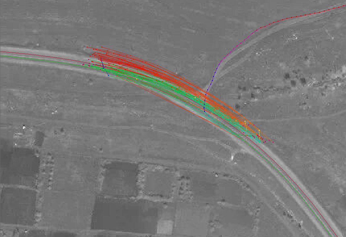 Two single tracks, currently perfectly aligned with road, are from precision GPS measurement (raw data processed with RTKLib). Image was shifted several meters away from the true position before it was aligned to these two tracks.
The whole bunch of red and green lines near the intersection are tracks, collected by different people using their dash receivers, handheld navigators and smartphones. All of them are systematically shifted away from the road because of Kalman algorithm filtering, implemented in every conventional GPS receiver to eliminate sudden jumps of track.
Two single tracks, currently perfectly aligned with road, are from precision GPS measurement (raw data processed with RTKLib). Image was shifted several meters away from the true position before it was aligned to these two tracks.
The whole bunch of red and green lines near the intersection are tracks, collected by different people using their dash receivers, handheld navigators and smartphones. All of them are systematically shifted away from the road because of Kalman algorithm filtering, implemented in every conventional GPS receiver to eliminate sudden jumps of track. See anything about relations? Me neither. One should scroll the sidebar down to see at least small section with “All relations” title. And, because there is a tendency to hide “very complex” concept of relations from the newbies, there is a huge chance, that one of them will just disregard that section as “something out of his scope of simply editing the map”.