BushmanK's Comments
| Post | When | Comment |
|---|---|---|
| Creating a New Diary Entry "Parsed by Markdown" | Flickr does allow you to copy image URL, if you’ve made your pictures downloadable in account settings. For example, go here https://www.flickr.com/photos/itoworld/3184111672/ , click on icon with arrow down next to “add to favorite” and “share”, click “All sizes” and it will get you to https://www.flickr.com/photos/itoworld/3184111672/sizes/ page, where you can switch to desired size, right-click on it and copy image URL. Another way to do it is to use “Share” button, switch to BBCode mode there, pick desired size and copy resulting BBCode, which looks like this Then you just have to strip everything except the content of url tag. |
|
| Why copying visual style of paper maps is not a good idea |
Being able to identify features in case when you have more colors is not that big problem, if colors are picked logically. Often, you can easily guess, what’s the meaning of some of them just by looking at map. Like in case of residential and non-residential areas. Or in case of conifer and broadleaf woodland (when conifers have darker green fill color). For sure, if colors and symbols are randomly picked, it makes a mess. But military map styles were created for only one purpose keeping in mind making them cheap, not to represent more information - military maps just don’t need much of it. In addition to that, I should mention, that your own perception of military map as of something obvious is based on your own experience and knowledge. For some person, who had no experience with it, some things are not that obvious. For example, all features like fields and wood have borders (dotted line). You know that it’s just a symbol. But someone can get an idea that it could be some soft of drain trench or something. And at certain scale, it’s hard to see the difference between these dotted lines and small rural houses, aligned in line along the road. So, military maps are obvious only for those who got used to them. They are not even close to any good example of design in general, they are good only in given circumstances. |
|
| Why copying visual style of paper maps is not a good idea |
English is not my first language, but I can’t figure out, where exactly did you find anything about color representation as primary factor. My view is that these factors (and some others I didn’t mention, such as multi-scale representation of digital maps, for example) are more or less equally important. So, what I really dislike in any discussion is to argue about things I didn’t actually say, but my opponents somehow managed to read between the lines. And speaking of resolution - thinnest line in Soviet topo map standard is about 0.25 mm wide, while on modern display, pixel pitch is usually 0.2 mm or even better. Smartphones have twice smaller and even finer pitch. Therefore, we can’t really talk about seriously worse resolution. As I said before, digital screen has no problems with color registration and color trap, which means we can use styles which are close to impossible on printed maps, such as semi-transparent hairlines (for minor horizontals, for example, to avoid clutter) or differently colored hairlines right next to each other. So, even having a bit worse resolution, it’s possible to compensate for it at significant grade, using extra freedom and advantages of digital screen. Indeed, USGS uses same styles for new GeoPDF topo maps with layers and so on, as they used for printed ones. But it only means that it serves them well enough. In more extreme cases (Soviet military topo) it can’t serve perfectly for any other purpose than war, since it lacks all kinds of important information. And it’s not about representation or style, it’s about purpose. And even in perfect case of USGS maps, there is certain way for improvement. For example, semi-transparent horizontals will allow to use layer visibility switch less than you have to use it now, because currently, solid dense horizontals do make it look cluttered. |
|
| Почему и когда разные трактовки в определениях в Wiki на разных языках - это нормально | @Zverik, и что это за желтый заголовок в твиттере Штосма? Повторю: эта заметка не о track. А о том, что трактовка любого тега в англоязычной и немецкой документации - не истина в последней инстанции, но отличаться местная трактовка может (и должна, когда в английской и немецкой все недостаточно четко) только в сторону большей четкости и конкретизации применения тега, а не куда-то в сторону или в направлении более общей трактовки. |
|
| Почему и когда разные трактовки в определениях в Wiki на разных языках - это нормально | @Zverik, эта заметка - не от track. Обсуждение track - просто повод. Как пример, я использовал башни и мачты. Если человек читал статью о них - все будет понятно. Если никогда не читал и не хочет - это не моя целевая аудитория. |
|
| Nonsense values of shop= key |
As you can probably notice, I’m not opposing adding brands, I just don’t want to propose anything for it, since I’m considering it less important (for myself). If you want - okay, no problem. But I’m positively against any attempts of matching wildcard entities (such as “supermarket”) with default sets of goods, since it is quite different from country to country and having separate reference lists of defaults is redundant. |
|
| Why local assumptions are wrong for an international project |
This is an opposite situation, when there is an actual clear real-life standard. Therefore, certain rule could be introduced, such as using |
|
| Trees (again) |
As far as I know, @igitov has certain connection to forestry management, therefore, his scheme is good. Not ideal, for sure, since “mature” seems to be better term than “adult”, for example. I believe, this scheme can be polished and officially proposed. And speaking of map rendering - I have an idea of using those icons, currently used for wooded areas in Standard style, but with different fill patterns: fully filled for evergreen, half-filled (just one side) for deciduous and other non-evergreen, not filled - for unknown. With leaf type it’s a bit more complicated, since for mixed, needle-leaf and broad-leaf it is possible to use those two tree icons, however, there is no way to indicate unknown leaf type. |
|
| Trees (again) | There is pretty good tagging scheme for forestry, developed by @igitov , but unfortunately, it’s not translated in English yet. I probably have to do it some day. |
|
| Nonsense values of shop= key |
Absurd, because you’ve made an extreme assumption and all your argument is about that extreme variant with inventory list, broken down to every single product. That’s not what I’m talking about and not even close to it. Several times I’ve mentioned “product groups”. Groups can be small, large, very different. But being non-exclusive, this scheme should allow to use any scale of abstraction and verbosity. And any level is better than “convenience store”. Obviously, more verbose categories are harder to maintain than less verbose ones. If someone will want to go super-verbose - why not, it’s up to mappers. I just want to discuss a better tool for store tagging (better scheme). Categories have to be uniform and documented, since more general any category is, more chances that certain culture has own way to use it (like I said - in Russia beer is not an alcohol drink according law, while somewhere else it is). Again, I have to mention “reasonable verbosity”. It is practically impossible to make everyone satisfied by describing product range of particular store in every detail. There are several reasons for it: amount of work, constant changes in inventory, constant changes in supply availability. It even makes certain things non-verifiable, so - no place in OSM, sorry. That’s why I’m insisting on more or less general, but straightforward and clear categories. If you personally would like to extend it with brands or whatever and make more detailed - you are welcome, just don’t make me doing that. What I actually really dislike and oppose is direct linking product ranges and stuff like “supermarket”, “convenience” and so on. This would be too synthetic and unnatural without any gain. Using Healthcare as an example, you can clearly see the difference between single blanket tag (medical facility in general), tagging down to clinic specialization (which seems to be enough verbose and verifiable) and tagging down to every doctor and every room (which is an overhead for the most cases). Education 2.0 is not my proposal, and currently I’m abstaining from working on it (however, I acknowledge, that it’s very important), but Healthcare 2.0, at least in its minimalist form, is very good, and I’m always using it as an example, since it is capable to describe specialization of any medical facility. As I said before, good scheme is flexible and extendable. I can’t see, why mapping product ranges can’t work this way. |
|
| Why local assumptions are wrong for an international project | Oh, sorry, didn’t mean to use horizontal line for making it a heading. Markdown is full of surprises… |
|
| Why local assumptions are wrong for an international project |
In theory - yes, if you bring everybody in class and make them listening to several lectures, have debates and so on. But once you can’t even make them read your explanation of something, it’s useless for changing anyone’s existing stubborn attitude.So, it only shows, that it’s important to keep up with current version of documentation. |
|
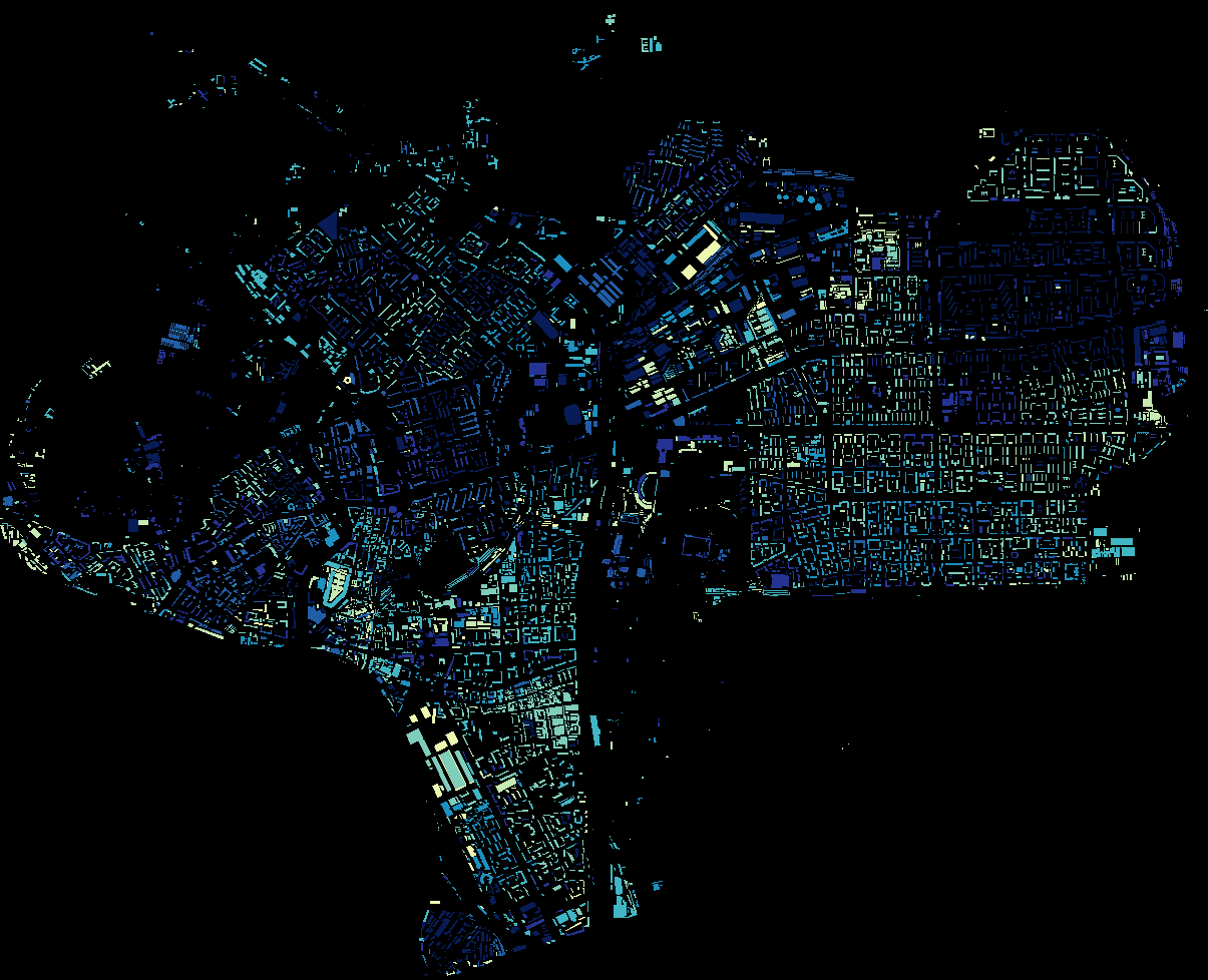
| OpenStreetMap past(s), OpenStreetMap future(s) | This is just an part of Moscow - Eastern administrative district (major part of it), colored by age of last changes in building geometry. Darkest blue - 2016, pale yellow - 2009.
Open in separate window for better resolution. So, you can see, how many buildings were mapped more than five years ago. |
|
| OpenStreetMap past(s), OpenStreetMap future(s) | I can probably tell something about Moscow.
I’m not trying to say, that map of Moscow is underdeveloped, but I’d say, that constant growth is still goes on there because map is far from being saturated. |
|
| Nonsense values of shop= key |
Some of your arguments are pushing everything to the limit of an absurd. Here, I’m not trying to push any maximalist ideas of “complete revolution in shop tagging” - OSM is perfectly flexible for having many independent schemes of tagging, satisfying different people. But somehow, majority of commenters just want to exercise in telling me that only one (old and often meaningless) scheme has a right to be used. I also have never said, that we have to break everything down to a single product by attaching shop’s full inventory to its contour. However, there is significant advantage of non-exclusive product category tags (even with quite rough and general categories) over blanket tags such as “supermarket”. At least, it potentially allows any search mechanism to narrow search results down. I have to remind, that in OSM we have huge amount of hard to use, complicated and very detailed schemes, which are in use by mappers, but nobody really knows if they are supported by some end-user software or hardware. So, why so much intolerance towards just another one? And there is nothing unrealistic in attempts to introduce this kind of scheme. I have several years of experience in product database development both for retain and b2b, with product ranges from sport gear to avionics. So, I know something about reasonable product categories, right? Regarding of your question - from OSM data I expect simple things: consistency, uniformity, schemes without self-contradictions and mutual contradictions, clear definitions of tags and values, proper usage of abstraction and generalization. By “uniformity” I mean equal definitions regardless of country, language, culture. Nothing of things I expect is new, everything is more or less reproducing core principles of OSM. One thing I’d want to expect from OSM contributors is some sort of will to evolve for better results. Which is rare thing, if you’re judging by comments here. |
|
| Why local assumptions are wrong for an international project |
They, probably, do read manuals (at least, I know it from that case with hangars in Russia), but they think, that “local traditions” are more important. And I don’t see any way to change it, since education is about knowledge, not about attitude. Again, it’s not a problem of being unaware of right way to do that, it’s a problem of being stubborn. In my previous diary entry you can see at least two comments from people from Belgium and Germany, where they also prefer to insist on something like “… but here in our country we think it means that, and it works for us”, which actually means “we don’t give a shit for uniform standards of mapping, we care about our country only”. |
|
| Nonsense values of shop= key |
Okay, I see, you’ve just changed the scale of problem. However, currently I’m not really interested in discussing particular cases since my diary entry covers the general one. Case of gas stations is different only in aspect of consequences, which could be much more significant in case of lack of information or too general information, therefore, people are more careful about refueling than about purchasing food or clothes. So, it’s just a question of attitude, which is subjective. But in terms of information architecture, these are definitely similar cases, since product groups are as easy to identify as fuel types. In one of my previous diary entries on topic of “myth of newbie” I already have it explained, that since we don’t have reliable model of mapper’s behavior, all assumptions such as “nobody will use it” and similar ones are nothing but personal assumptions. Fundamental principle of OSM is “any tags you like”, and I don’t see any problem with introducing better set of tags. All that resistance I’m seeing here in certain comments looks like an expression of stubbornness and desire to protect precious familiar nonsense no matter what, because people trying to argue about things I have never said, presumably existing in their own mind only. |
|
| Why local assumptions are wrong for an international project | @Vincent de Phily, I hope you are not talking about culture-dependent meaning of each tag, since it’s against the fundamental principle of uniformity. If you do mean it, then our Wiki should be transformed into a study of culturology, which doesn’t seem like realistic task. Also, if tags will have own meaning within the borders of each country, it will render the whole database practically unusable without reading the whole documentation and taking every cultural feature in account. Sounds like an utopia for me. Unlike much more straightforward task of unification, which at least seems to be a finite problem. |
|
| Why local assumptions are wrong for an international project |
I’m glad you’ve recognized computer science in my description of this problem. But using a straightforward additional tags, based on scientific approach does not require a degree in database engineering. Is it too hard to add something like I just can’t get it, why the hell people here think that I want to deprecate and prohibit dear old (nonsense) tags? Those who want to continue playing mapping with those tags can do that as long as they want. But your statement that nobody will use detailed schemes is based on nothing but assumptions. That is typical and it was already proven to be wrong by several existing schemes, which are way less obvious and much harder to use. |
|
| Nonsense values of shop= key |
“Gifts” is just a random existing value I’ve used for illustration purpose, and there are 20k entries of Mentioning gifts as second category of products, sold by this hypothetical two-department shop in addition to flowers, I had no intention to discuss this particular value. My intention was to demonstrate, that currently there is no good, consistent, non-cumbersome and non-redundant way to tag any shop, not “focused” on single category of products. My view on using semicolon-delimited lists is already expressed above in reply to @dcp. You’ve got carried away with |