AzerAkhundov's Comments
| Changeset | When | Comment |
|---|---|---|
| 152912603 | over 1 year ago | Vandalism detected. User is deleting names and adding fake ones. #NameCheck
|
| 141950247 | over 2 years ago | I guess now I am under total control by moderators ))) |
| 141599185 | over 2 years ago | Yes, exactly. I generally use openstreetmap.org in standard version. I thought if you change in opensteetmap.org it affects all other maps with OSM data, so there is no difference. |
| 141599185 | over 2 years ago | When editing, there is a "Name" bar above and many "Multilingual name" bars below. I noticed that the one in the "Name" bar is displayed on the map. |
| 141599185 | over 2 years ago | Also, I agree that there should be multiple names. But which one will appear on the map? As the area is considered as Azerbaijan, it will be logical that they appear in Azerbaijani. Nobody lives there now. |
| 141599185 | over 2 years ago | The same is applicable to other villages and towns. Most of the residential areas were destroyed and nobody was living in them. But why were their historical names changed to Armenian? I repeat, I was warned in early 2020 when I changed town name Zangilan. I was told that, it is controlled by Armenians and signs are in Armenian there, so it should appear in Armenian. But historically this place was called Zangilan even in Soviet era. I waited and after the war edited again and brought back its historical name. Question is, why it is ok when names are changed to Armenian after occupation, but it is not ok when they are turned back to original ones in Azerbaijani after deoccupation? |
| 141599185 | over 2 years ago | Hello!
|
| 92664162 | about 5 years ago | I watched the video by using VPN. It is a new video. Soldiers are from Azerbaijan :) I will inform you when the sign is changed. |
| 92664162 | about 5 years ago | I cannot see the video due to the internet restriction, but as I understood, if the sign is changed the name can be changed on map. OK. Let's wait for a few weeks, soldiers are demolishing old signs and installing new ones. I will inform you when I find a photo of new signs. By the way, what is the date of the recorded video? |
| 92664162 | about 5 years ago | Hi, it is not disputed, it was under occupation and it was liberated in October. The town is under Azerbaijani control and its official name is Qubadli. Armenians never lived there, they only lived in Nagorno Karabakh area. Qubadli is not Nagorno-Karabakh region. |
| 93189350 | about 5 years ago | Emptiness of these villages is a temporary thing. All of them will be built again and displaced people will move back to their homes. They are still considered as a villages according to Azerbaijan administrative division. |
| 93189350 | about 5 years ago | That is exactly my point of view. Question is: if nobody lives in a town or village, why their name appears in Armenian? Why not in Azerbaijani? I understand Armenian names in the villages where only Armenian population currently lives (temporarily). But what about ghost towns and villages? Why my added names are changed to Armenian names? |
| 83403866 | about 5 years ago | Exactly. There is no real border between occupied territories and Armenia. But it doesn't mean Eyvazli is located in Armenia. It is located in occupied territories of Azerbaijan. |
| 93189350 | about 5 years ago | Look, I added this place few months ago, And I added as a Azerbaijani name. But someone deleted name and changed to Armenian. Why you don't warn them? If someone deletes names and adds other names it is not OK.
I still cannot understand your attitude. Qaraagac village was liberated today by Azerbaijai army. Nobody lived there for 27 years and today it is controlled by Azerbaijani army. |
| 72694642 | about 5 years ago | Official sources, president announces liberated places. There are video footages of Azerbaijani flag raising in Zangilan city since 20 October 2020. As of population, nobody currently lives there due to the operation against terrorists. It is under control of Aerbaijan army, so Azerbaijani soldiers are living there :) If OSM tends to reflect the local population's language, then why names of ruined villages are in Armenian? If you look close to most ruined villages, there are no people living in them. Then why Armenian? Why not Azerbaijani language? :) |
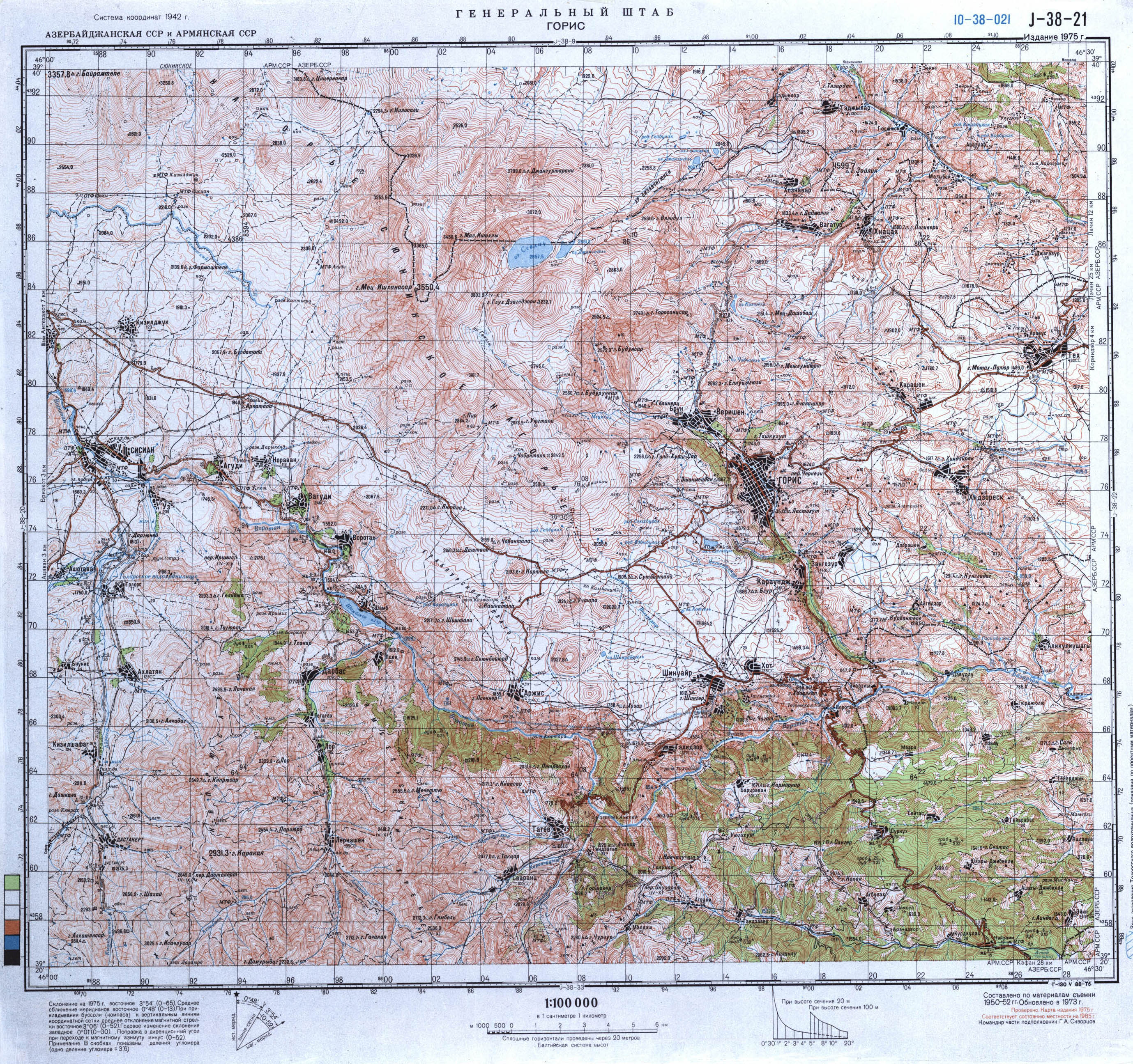
| 83403866 | about 5 years ago | Well, it is obvious. Just search for Eyvazli village. You can check old soviet topomaps if you want. Eyvazli is village of Gubadly region of Azerbaijan. https://maps.vlasenko.net/smtm100/j-38-021.jpg Just look at intersection of lines 20 and 68 (western part of map). You will see Eyvazli village and Azerbaijan border. It is Soviet map, but officially borders are the same after collapse of Union. |
| 72694642 | about 5 years ago | Hello, it is officially under control of Azerbaijan forces. So, according to the rules of openstreetmap the name shown should be in Azerbaijani at first. Some of my changes were deleted by other armenian users, so I will change them back. Please note that, I only change the names that are officially under Azerbaijan control. Everyday some villages and territories are liberated from occupation. I only change the liberated villages. Also, some of my edits were deleted by other users. They deleted Azeri names and added Armenian ones, but they could have only add Armenian without deleting Azeri names. Please note that. I will change only officially liberated territories. |
| 83403866 | about 5 years ago | Yes, it is officially located in Azerbaijan territory. Check other maps and you will see it. Eyvazli village of Gubadly region. https://gomap.az/maps/az/@/map;lt=39.43449595906043;ln=46.395572662353516;z=13 |
| 72694642 | over 6 years ago | I have many questions about that issue. Does that mean that if for example in USA in one locality there are more Chinese people than local ones, they can add the locality name in Chinese language and alphabet? And when you look at openstreetmap from other part of the world, you will see the locality in USA in Chinese language? The other question is about Nagorno-Karabakh republic which is not recognised by any country in the world. Is that correct to add its name as a country and its boundaries? What if I declare a country that nobody recognizes and start to add it in other parts of the world? The same problem was once in Google Maps, finally they changed the names to official ones and started to show both names in both languages, like (Zəngilan/Kovsakan). |
| 72694642 | over 6 years ago | Hi, I changed the name to its official version. I cannot understand why the names of towns and villages in Azerbaijan are shown in Armenian and even in Armenian alphabet. I know that the area is under occuapation and disputed but even if so, i think both names should be added. The territory is officially recognised as Azerbaijan. |