
OSM aurait une icône à afficher pour informer de la présence d’un parcours de Disc Golf ?
Oui oui, ça s’affiche dans OsmAnd sur Android…
Pourquoi toujours pas sur osm.org ?

Oui oui, ça s’affiche dans OsmAnd sur Android…
Pourquoi toujours pas sur osm.org ?
It was like getting back to the start point for all of us, revisiting the basics of OSM with my in-person training in Grab last June 30 for the KartaView x OSM Philippines meetup event. It was a great event that allowed me and fellow mappers to share about our knowledge in Basic ID editor and other mapping methods while also contributing to map data in areas recently affected by the Mt. Kanlaon eruption in the Philippines.
Truth be told, a lot of the participants are already quite experienced when it comes to OSM, but this also provided me the opportunity to have a more hands-on teaching session with those that are still learning or still getting used to the Basic ID Editor. It was a great experience to be able to teach and guide more closely and watch our beginner participants progress and be able to contribute to the task, beginning with creating an OSM Account, to adding features through ID editor and saving their changes!

3年前には横浜市北部の青葉区、緑区、瀬谷区の建物を中心としたマッピングを行った。 今回は都筑区、旭区、港北区について行った。
・港北区は既に8、9割終わっており、 東急日吉駅近辺およびその北部など、取り残されていた地域について行った。
・都筑区は地下鉄駅周辺は終わっており、残りの7割程度を行った。
・旭区は駅周辺や相鉄本線以南はほぼ終わっており、残りの8割程度を行った。
・横浜市北部の前に、こどもの国の真北の三輪緑山の建物のマッピングを行った。 確か3年ほど前に誰か(ひょっとすると、自分自身?)が2、3割の建物のマッピングを行ったので、 先に進むことを期待していたが、その後、その気配がないため、残りのマッピングを行った。
2024.9.10
・ゆかりの地(富山県、兵庫県)を見た。5~8年前とあまり変わっていない。 正直なところ少しがっかりした。 日本全体では、OSMデータファイルのサイズは2倍以上に増えているだろう。 大都会のマッピングが進んだのだろう。
・人口1万数千人のゆかりの田舎町をマッピングしてみた。 時間がかかるのは、建物であるが、農地などのマッピングも行った。 住宅内道路はマッピングされていないものが多かった。 建物については近接して農業用小屋や駐車用小屋などがあると、 国土地理院地図では全体がひとつの大きな建物となっており、 オルト地図や Bingの航空地図でも精度が悪く、 ひと繋がりの建物か、分離した複数の建物か判然としないケースがよくある。 全体として都市部に比べると、人口1万人当たりのマッピング時間は、 3~5倍かかるようだ。
S obzirom na značajne infrastrukturne promjene u Rijeci i njezinoj okolici, u planu je unaprijediti detalje vezane uz odvijanje javnog prijevoza u Rijeci i okolici, posebice na području Grada Rijeke te Opatije, Matulja i Kastva.
Projekt unaprijeđenja javnog prijevoza u Rijeci obuhvaća provjeru ispravnosti podataka o linijama, stajalištima i trasama, uvođenje privremenih trasa i stajališta gradskih i prigradskih linija za vrijeme trajanja opsežnih radova vodovodne i komunalne infrastrukture na području centra Rijeke, ažuriranje nazivlja autobusnih stajališta i ispravljanje lokacije u prostoru, ažuriranje autobusnih linija i trasa prometovanja, ažuriranje tipa, vrste i pozicija stajališta, dodavanje informativnih displeja, autobusnih čekaonica i urbane opreme (klupice, kante za otpad, vozni redovi) na prostoru autobusnih stajališta, uređenje popratnih sadržaja uz autobusna stajališta (peroni, terminali, prostorije kupnje i prodaje karata) te ažuriranje svih podataka vezanih za prodaju karata.
Projektom (faza 1) su obuhvaćene:
Projektom (faza 2) su obuhvaćene:
Projektom (faza 3) su obuhvaćene:
Pri ažuriranju podataka koriste se službeni podaci KD Autotrolej i Grada Rijeke te interne informacije i aktualne obavijesti.
Nije uneseno.
Ovdje se prikazuje dinamička i postotak (%) završenih radova ovisno o vrstama promjena na OSM kartama:
Either include my portion it’s on my map
Otilo
Miejscowość: Gdów Powiat: wielicki Województwo: Małopolskie Kraj: Polska
Na terenie miejscowości Gdów zostały wprowadzone nazwy ulic co spowodowało zmianę numerów domów. Proszę o aktualizacje.
Przykład:
Stary adres: Gdów 365 Nowy Adres: ul. Stadnicka 44 32-420 Gdów
Hi, I’m known as catme0w on the internet, and I’m a contributor to Google Summer of Code 2024. Below are my contributions during GSoC.
This post is not yet complete and will be updated gradually with detailed progress throughout my GSoC journey.
These goals were initially discussed and finalized at https://github.com/stadiamaps/ferrostar/issues/102.
You can find all my contributions to Ferrostar at https://github.com/stadiamaps/ferrostar/pulls?q=is%3Apr+author%3ACatMe0w.
Here’s a web demo: https://stadiamaps.github.io/ferrostar/web-demo/
Lastly, I would like to sincerely thank my mentor Ian and Jacob for their assistance. I’m glad to have met such an outstanding team. Without their support, none of this would have been possible.
원앤온리PT 부산교대점
Zbieram informacje, gdzie zaczyna/kończy się strefa ograniczonej prędkości, bo dane są trochę przestarzałe: note/4404285
Przy okazji, na dalszy etap, za info o ograniczeniach wagi i parkowania i “strefach zamieszkania” czy progach zwalniających też będę wdzięczny :)
Sailing today with P&E.
Forecast was for 10 knots with gusts to 18.
Easy out of the marina and then across the fjord to Nesodden. Very lumpy and heeling over. P&E learnt a new word “goffered” ie to get a wave in the face.
Кроме того, хочу поделиться еще одной радостной новостью. Наш валидатор 3D зданий наконец стал показывать ошибки (не прошло и пяти лет!)

Посмотреть можно например тут.
Так же, если так удобнее, ошибки показываются для каждого здания отдельно.
Основная и чаще всего встречающаяся ошибка – это отсутствие значения высоты (height)=* на билдинг-парте. Билдинг-парт без высоты – вещь совершенно бесполезная и отрендерена быть никак не может.
Также встречаются опечатки в roof:shape, перепутанные roof:direction и roof:orientation, а также неразборчивые даты постройки (start_date)
Так что если не знаете чем заняться – гляньте свой регион.
Когда-то давно, мы с вами рассматривали топ-100 самых проработанных 3D зданий, даже ролик про это сняли.
Прогресс не стоит на месте, и с тех пор топ значительно обновился. Во-первых, в список ворвался Челябинск, а во-вторых, рухнул казавшимся нерушимым рекорд по количеству билдинг-партов на одно здание.
Итак, приветствуем нового чемпиона: Кафедральный собор Рождества Христова в Челябинске:

Этот шедевр включает 6375 билдинг-партов. По словам автора всё делалось вручную, методом копи-пейст. Как автор с ней справился, я не представляю.
Кажется, что с подобным уровнем детализации даже отдельное текстурирование не нужно.
Предыдущий шедевр, напомню, включал 1088 частей и принадлежал мечети «Сердце Чечни» в Грозном.
Полностью с участниками топа можно познакомиться здесь: http://3dcheck.zkir.ru/rus-top.html
Desde que conocí OpenStreetMap, me impresionó la cantidad de trabajo que ha puesto la comunidad en construir un mapa súmamente detallado del mundo, donde se muestran las particularidades de cada lugar, y donde se brinda la posibilidad de aplicar los datos para el uso de todas las personas.
En particular, el municipio donde vivo no cuenta con un mapa muy completo. La cartografía urbana está desactualizada, y nada qué decir de la rural.
Es por eso que hace un par de meses decidí iniciar la campaña de mapeo de todo el territorio, empezando por la zona rural.
Como he trabajado durante un par de años en la administración municipal, tengo conocimiento de la estructura geográfica del municipio. En particular, quise iniciar el proyecto de manera organizada, tomando como punto de partida la vereda número 1: Cascajo Arriba.
Primero, tomé el archivo vectorial de las veredas del municipio, y exporté el polígono de la vereda en formato GeoJSON. Para esto, usé QGIS.
Con el archivo guardado, procedí a la creación del proyecto en el HOT Tasking Manager, al cual tuve acceso gracias a la Comunidad OSM Colombia. Al proyecto le fue signada la tarea #16940.
Usé el archivo en formato GeoJSON para delimitar la zona de trabajo (área prioritaria) y crear 71 tareas.
Para digitalizar los elementos del mapa (edificios, cultivos, bosques, ríos, carreteras, etc.) utilizé la ortofoto de la zona rural del municipio a través del servicio WMS disponible en Colombia en Mapas. Esta ortofoto corresponde a imágenes del año 2023, por lo que son datos muy recientes y confiables para la digitalización de elementos.
Taas jatkuu yksi kesä paikkapistepuutteiden täydentämisen osalta samalla, kun tulee pyöräiltyä milloin minnekin. Työkalut itselläni tähän mikrokartoitukseen kehittyy ja optimoituu hiljalleen sen perusteella, mitä tehokkaampia tapoja ja välineitä tehdä asioita tulee löydettyä.
OpenStreetMapin dataa on mahdollista päivittää mikrokartoitustasolla kahdella eri lähestymistavalla:
Olen valinnut päivitystavaksi tehdä asiat paikan päällä kentällä pyöräillessä ja vain poikkeustapauksissa jatkan kotona. Viimekesäiset varusteet on vaihtuneet kokonaan toisiin, tarjoten hieman paremman kokemuksen. Nämä on nähtävissä kuvasta 1.
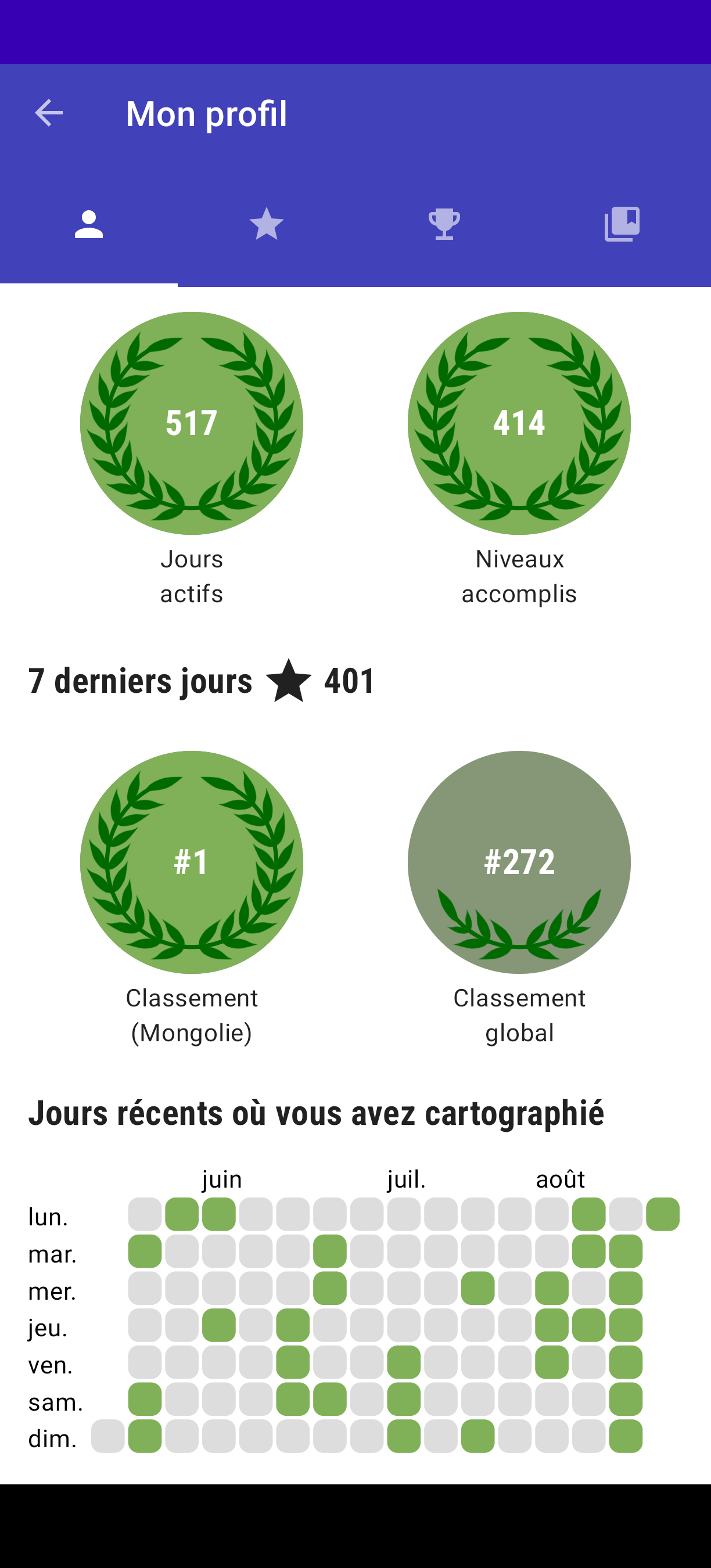
Ma femme étant mongole, je visite le pays plus ou moins régulièrement. J’ai essayé de le cartographier ou d’en ajouter des détails à chaque fois. Mais jusqu’à présent, je n’y étais pas parvenu.
Cette année j’avais prévu d’avoir de la 3/4 G tout le long de mon séjour, mais pour des raisons techniques, je me suis retrouvé en mode WIFI pour 95% du temps que j’y ai passé. J’avais donc prévu d’utiliser Vespucci et StreetComplete de manière intensive.
Comme je suis passé en mode wifi, je n’ai pu utiliser StreetComplete que dans la capitale. Cela ne m’a pas empêché de finir premier au classement :p (genre dès la première quête complétée)
Ich habe eine Anwendung in der, ausgehend von den Koordinaten:
52.27070436093613 / 13.947154283564489
über Leafelet der Ort Kolpin ermittelt wurde. Genauer wäre der Ort Storkow.
Wie kann es zu dieser ungenauen Zurodnung kommen?
BUILDINGS ADDED BY USER ZH9567 IN OPENSTREETMAP AROUND THE KLANG VALLEY AS OF 20 AUGUST 2024
Data generated through Overpass Turbo, with all features with the tag building=* on OpenStreetMap with latest revision made by Zh9567. Note that it include buildings added by others and last updated by the user, but not include buildings added by the user and got updated by other users.
As we can see in the map, Zh9567 mapped many buildings around the Klang Valley. They are mainly concentrated in Klang, southern Shah Alam, Subang Jaya, Puchong, Seri Kembangan, Kajang, Cheras, and Ampang.
As of 20 August 2024, there are 715,932 buildings (23,987 hectares) added into OpenStreetMap in Kuala Lumpur, Putrajaya, and Selangor combined. Zh9567 has added and updated 510,000 buildings (11,007 hectares) around the region, with a total of 71% (or 45.9% if counted by hectares). And these numbers will continue to rise in the future.
This is quite a major contribution in OpenStreetMap. Let’s help improve OpenStreetMap together!
Kindly fill in our survey about knowledge and opinion of maps among Malaysians (for Malaysians only at the moment): https://docs.google.com/forms/d/e/1FAIpQLSc5KOuuNLtZAAkFU8DYO_-xjZixJVTY3NukRORiIfLtGGaQVA/viewform?usp=sf_link
Support us on Patreon: https://www.patreon.com/Zh9567
Support us on Ko-fi: https://ko-fi.com/zh9567
No, not that kind of a minister!
Anyways, at the moment, Heritage Week is on in Ireland, and I gave a talk on Monday in our new library building (on OSM) about “Citizen Science and Linked OpenData” using mostly my holy well survey as an example, but a bit the Ogham Project as well. I used one of the toilets in the library to explain how the general tagging works, because it is quite nano mapped and relatable.
The Minister for Heritage (and other things) was present and kindly posted on Facebook about it afterwards: https://www.facebook.com/MinisterMalcolmNoonan/posts/pfbid09t7ubGw1CgEN6vNZeUqTGFngepAsKsARzxiJbinr6siLtn9ovPuXdEA46spxdW8xl
Just for context, in the first photo, he’s the guy in the middle, and the elderly people are descendants of Hubert Butler (on wikipedia), they were the other VIP guests so to speak.
It’s a busy week for him, so I was pretty happy that he attended and promoted OSMin his post. (Even though we still have to work on the spelling, but at least he didn’t use the plural like so many other people.)
I talked about the Wikiverse as well, of course. Wikimedia Ireland dedicated a blog post to it beforehand as advertisement for the talk. Thanks very much for that as well!


