OpenStreetMap logo OpenStreetMap

Users' Diaries

Recent diary entries

Posted by IrdiIs on 16 June 2024 in English.

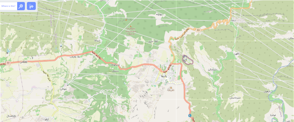
It took me 4 days to finish mapping this village because I could only map for 5–10 minutes every day for the past 4 days. It was fun, though, mapping during the coffee breaks while volunteering on WordCamp Europe.

Contributing to an open source project does not mean contributing to code. There are so many ways to do from translation, meetups, volunteering, etc. My favorite one, especially for WordPress, is to volunteer for WordCamps and this one was my second. It is tons of fun contributing to bringing together around 3000 participants in a 3-day event from all over Europe and more.

Next year will be my third year contributing to WordCamp Europe and I already applied to join the organizing team. Can not wait to start working on it.

Good news is from tomorrow, I will be continuing my personal challenge and keep mapping!

“#100villagesin100days #day13”

Greetings! Welcome to the first entry of my diary. Here I’ll be sharing my experience as an OMGuru, i.e., Open Mapping Guru.

Open Mapping Guru is a training program for next generation individuals who are seriously interested in community driven Open Mapping, just kidding, it’s for anyone who wants to help the community by mapping.

There are a plethora of skills and softwares/interfaces to be learnt here, but more importantly meeting a lot of people of the same mindset is a boon.

For starters, I never got to enroll this with the others as a batch. I got to know about it after two months passed when two people left two seats open. But, the people working in OSM AP Hub are gems. They guided me in every way possible. I could cover all the necessary requirements in a very short amount of time, earning the skills in the way.

When I first started, I was reluctant.. thinking how can this mountain of tasks be covered within such a miniscule amount of time? But our guide from OSM AP Hub curated the tasks so well that I started enjoying it.

Then the Climate Change Challenge event started where we had to pair up as a team.i love it how they gamify the events and we learn the skills in the process. The person who came up with this idea is a genius.

I can’t fathom how it ended so soon. I’m so glad that I could get this opportunity. I determine to enroll again if they permit me, moreover help other aspirants get enrolled in the process.

Thank you for such patience. I’m really grateful.

Location: Maliabari, Digboi, Margherita, Tinsukia, Assam, 786171, India

Welcome to the eleventh OpenStreetMap NextGen development diary.

This week has been focused on the design and implementation of new user profile pages. Today’s profile pages are boring and quite limited — let’s fix that! 🧑

🔖 You can read my other development diaries here:
@NorthCrab/diary/

⭐ This project is open-source and publicly available:
https://github.com/Zaczero/openstreetmap-ng

🛈 This initiative is not affiliated with the OpenStreetMap Foundation.

Last Week’s Recap

Last week the project was opened for new contributors. The codebase is now stable enough to allow for greater cooperation. There are also contributor incentives to ensure your work is always appreciated.

Continue reading

New Profiles

» View in fullscreen

In summary:

See full entry

Posted by dpschep on 14 June 2024 in English. Last updated on 15 June 2024.

In January, I introduced Overpass Ultra v2. Today, I’m pleased to announce some updates to further improve Overpass Ultra’s customization capabilities, enabling you to make custom maps like this one:

Screenshot of a map of gardens in Richmond, Va made with Overpass Ultra

Loading queries from URLs & Gists

In order to facilitate sharing updatable overpass queries&maps, Overpass Ultra is now able to load queries from a URL or Github Gist.

To use this feature, specify either https://wiki.openstreetmap.org/wiki/Tag:query=url:... or https://wiki.openstreetmap.org/wiki/Tag:query=gist:... in the hash parameters. For example to load a Gist:

https://overpass-ultra.us/#query=gist:02ab2139d146dd2ee0306a38d96a9c9d

or to load that same Gist with the more flexible (but more verbose when using Gists) url: option:

https://overpass-ultra.us/#query=url:https://gist.githubusercontent.com/dschep/02ab2139d146dd2ee0306a38d96a9c9d/raw/8d4b0d38eac64e8dbd772284d4cc094708cd3b26/gistfile1.txt

Improved configurability for the Overpass Ultra “interactive map” view

See full entry

FOSS4G is the annual recurring global event hosted by OSGeo, the non-profit organization that supports and promotes the collaborative development of free and open source geographic technologies and open geospatial data.

🔸 CFP for Submission of workshop: From May 8 to July 12, 2024.

🔸 Workshop Evaluation: From July 22 to 31, 2024.

🔸 Full FOSS4G 2024 program: September 1, 2024.

More information in https://2024.foss4g.org

FOSS4G Deadlines

Location: São Brás, Belém, Região Geográfica Imediata de Belém, Região Geográfica Intermediária de Belém, Pará, North Region, Brazil
Posted by CurlingMan13 on 14 June 2024 in English.

I was recently asked how I find and review notes on the OSM US Discord (you should check it out!).

I use the following links to see recent notes. This one is all note actions, last 1k notes: https://resultmaps.neis-one.org/osm-notes-country?c=United%20States

This one is only open notes. It is only opened, commented and reopen actions. You can see the last comment. https://resultmaps.neis-one.org/osm-notes-country-custom?c=United%20States&query=open

I start with the most recent notes and work my way back. The notes can vary wildly. Some are onosm.org ones where a business submitted a request to be listed and all that is needed is to validate it exists, the tags are correct, and it is correctly located (according to reported address), and then you add the business w/ appropriate tags. Some are to identify an error or addition that is beyond the editor being used. Some are clearly spam (Ex: Give CurlingMan13 a beer and a raise!), but you get a feel for it after a while.

Now before I submit that single changeset, I look around the map in that region and search for other notes that I can resolve (some are related, some are easy).

Another good source is NotesReview. You can search for specific text, age, specific users, etc. This one is really good if you want to kill off the oldest notes. https://ent8r.github.io/NotesReview/

Today I have been adding some of the Churches of the evangelical Mission I attend to.

I invite anyone to listen to the word of God (The Bible), and find about their salvation.

Here are some youtube links: * French YT Channel * Spanish YT Channel *English YT Channel

(Matthew 7:21-13) >21 Not everyone who says to me, ‘Lord, Lord,’ will enter the kingdom of heaven, but only the one who does the will of my Father who is in heaven. 22 Many will say to me on that day, ‘Lord, Lord, did we not prophesy in your name and in your name drive out demons and in your name perform many miracles?’ 23 Then I will tell them plainly, ‘I never knew you. Away from me, you evildoers!’

(1 Timothy 2:4) > 4 [God] who wants all people to be saved and to come to a knowledge of the truth.

(Romans 3:20) > 20 Therefore no one will be declared righteous in God’s sight by the works of the law; rather, through the law we become conscious of our sin.

Posted by Robhubi (inaktiv) on 12 June 2024 in German (Deutsch).

Das ist mein letzter Beitrag, bevor ich mich von OSM verabschiede. Es war eine schöne Zeit, aber in den letzten Wochen und Monaten bin ich immer mal wieder auf Rücksichtslosigkeit, Destruktivität und Respektlosigkeit gestoßen. War es früher besser? Ich weiß es nicht, vielleicht wird es mir jetzt nur bewusster. Auf jeden Fall ist die Freude am Projekt immer weniger geworden.

Rückblickend überwiegen aber die vielen Erinnerungen an die so positiven Begegnungen mit den Mapperinnen und Mappern. So schließe ich dieses Kapitel leichten Herzens.

Alles Gute! Robert (robhubi)

Today I mapped Lavdar i Korçës which according to OSM data has a population of around 1152. The village was not very big, and I was quite motivated today, so I moved to another village close to Lavdar.

Polenë, according to OSM data, has a population of around 752. Did not fully map it, but I think I might have mapped around 80% of the buildings. To my surprise, the streets were mapped pretty well.

I do hope I can continue to map daily for the next 4 days because I will be volunteering at WordCamp Europe in Torino. If I do not manage to map, I will catch up when I get back home.

“#100villagesin100days #day12 “

Today i mapped two villages from the list, Mokricë-Zleushë and Tenë.

Mokricë-Zleushë is a small village in Përmet. It is a tiny, remote village which also seems quite far away from the other villages around.

Tenë is a small village in Rrëshen. Another tiny, remote village far from the main road.

I would like to check how far from these remote villages are the closest schools, medical centers, hospitals, main streets and the closest city. I know it is possible leveraging OSM data and most probably QGIS or even JOSM (not sure about this). If anyone got some good tutorials and would not mind sharing, i would deeply appreciate it. Unfortunately, i do not have time currently to deep dive into either of those apps.

“#100villagesin100days #day11”

The link for the public version https://sdm.etica.ai/v/0.5/ I made an effort to make it easy and very cheap to host (currently is a client side static vanilla JavaScript+HTML app) and, as a side effect, the privacy of your data is kept.

Since I joined OpenStreetMap in 2022, I’ve done some tools without a graphical interface, and this one I’d love to receive feedback from potential users on such a very niche topic.

Already at early versions of it (I stated a prototype in 2023 mere debug for the real conflation done non interactively before load on OSM editors), I truly attempted to think how to make it as a plugin for JOSM or think how to extend iD instead of keeping it side-by-side with iD or alt-tabbing with JOSM.

The good news: It does have basic support to use one or more files to match by distance and/or by tagging with the one or more target files and then you download the geojson. Okay, addr:street would need language and country level comparison (because misspellings), and also addr:postcode may already have logic to tolerate near matches. If you know vanilla JavaScript to code a function to your country, then it could be more forgiving.

The bad news: for points of interest, the so-called “edgematch links”, “rubber shedding links” or whatever the term to be use to export file “these 0-N items in dataset A matches these 0-N items in dataset B” necessarily need human-in-the-loop and it happens in unpredictable ways. And links which aren’t obvious 1-to-1 (while there’s room for suggestion) require need human input. It started as the “typical leaflet” plus a text-only, but we might need a way to visualize N:M links (unless any you have an UI suggestion to plot such links already over pins in a map!).

See full entry

I first heard about the OMGuru Fellowship in November 2023 at the FOSS4G conference in Bangkok. Intrigued by the opportunity, I applied and was thrilled to be selected for the mapping fellowship. What followed was an incredible journey of learning, growth, and impactful experiences.

During the fellowship, I was introduced to various powerful tools such as JOSM, RapID, Mapillary, and the EverDoor app. Each of these tools enhanced my mapping skills and broadened my understanding of the technological landscape in the field of geographic information systems.

A significant highlight of the fellowship was participating in a climate change competition. This ongoing challenge provided me with hands-on experience using MapSwipe and MapRoulette and allowed me to lead a team, further honing my leadership and collaborative skills.

Over the past five months, the fellowship has not been without its challenges. Natural disasters such as an earthquake in Papua New Guinea and floods in Afghanistan required urgent mapping efforts for response activities. The OMGuru Fellowship equipped me with the tools and knowledge to contribute meaningfully to these efforts, opening doors to real-world applications of my mapping skills in crises.

The OMGuru Fellowship has been a transformative experience, providing me with invaluable skills and the opportunity to make a tangible impact. I am grateful for the support and guidance from OpenStreetMap and APHub, and I look forward to continuing my journey in the world of open-source mapping.

OMGuru

Introduction

Hello, fellow mappers! I’m excited to share my experiences as a part of the Open Mapping Guru Fellowship program for 2024. This journey has been an amazing mix of learning, challenges, and making a real impact in the world of open mapping.

From OSM Beginner to Validation Fellow

My OpenStreetMap (OSM) journey began in October 2021 during a training organized by the Geomatics Engineering Students’ Association of Nepal (GESAN). I was immediately drawn to the collaborative nature of OSM and its ability to create free, up-to-date maps for everyone. I wanted to do more than just make edits. That’s when I found out about the OM Guru Fellowship, which has tracks for Mapping, Training, and Validation. The Validation track really interested me, and I was lucky to be selected for it. Knowing that my work helps create reliable maps for disaster response, humanitarian efforts, and other important uses gives me a strong sense of purpose. It feels good to know that behind every useful map, there are contributors working hard to make sure it’s right.

Fellowship Experience:

Being a part of OM Guru Fellowship was more than just learning new skills; it was a transformative experience. The fellowship made me think critically about data quality and gave me more knowledge of powerful validation tools. From OSMCha and Osmose for thorough quality checks to MapRoulette for fun task completion, I learned to find and fix errors precisely. Each task was a new challenge, keeping me engaged and helping me improve as a validator.

My Learnings:

The biggest lesson I learned from the fellowship is the power of collaboration in open mapping. Every validation task, every discussion and every challenge shows the collective effort that goes into creating high-quality maps. It’s humbling to be part of this global network of passionate individuals, all working towards the same goal – a more accurate and accessible map for everyone.

My Achievement

See full entry