◈ 집중작성한거(대략 10개안팎 정도) : 군산, 서울, 원주, 익산, 인천, 전주, 춘천
◈ 그럭저럭작성(서너개에서 5개안팎 정도) : 광주, 구미, 김천, 담양, 대구, 부산, 성남, 세종, 시흥, 안성, 영주, 제천, 평택
◈ 한두개씩 : 공주, 안동, 영천, 천안, 횡성
◈ 집중작성한거(대략 10개안팎 정도) : 군산, 서울, 원주, 익산, 인천, 전주, 춘천
◈ 그럭저럭작성(서너개에서 5개안팎 정도) : 광주, 구미, 김천, 담양, 대구, 부산, 성남, 세종, 시흥, 안성, 영주, 제천, 평택
◈ 한두개씩 : 공주, 안동, 영천, 천안, 횡성

Si alguien necesita mostrar algo en un mapa puede usar OpenStreetMap para ello. Varias empresas, instituciones y aplicaciones lo usan ya sea para uso particular, institucional o gubernamental.
Existen listados donde se muestra que países y organizaciones lo usan.
En el caso de México se tiene un listado de ello aquí:
Si usas OpenStreetMap en:
no dudes en agregarlo a esta lista.
Con toda confianza puedes enviarme ya sea por X/Twitter, mastodon o telegram el link del sitio donde se muestre que se está usando OpenStreetMap y con gusto lo subiré.
I completed my first 100+ physical addressing on Magnolia Ave., Birch Run Ave., Redwood Rd., Hickory Rd., Elder Pl., Hemlock Dr., and Beech Pl. The project took about 3+ hours to complete. I’m new but will soon get into other tasks. ChangesetID: changeset/145716852
addr:city=Denville
addr:postcode=07834
addr:state=New Jersey
addr:street=
addr:housenumber=
I got my husband to join me and help me with mapping today. We went from approx. State Line Road in KC on 43rd St (we think of it as 43rd though there is a stretch that’s Westport Rd) and down to the west end of it just beyond Mission.
We went to Sway Coffee Roasters and had a nice cup of coffee/tea, and got to say hello to some sweet dogs that another customer brought with them. The dogs visited everyone within leash distance and everyone seemed happy to see them. Little random encounters are what make me love the city so much.
My plan next is to visit the stretch of 43rd east of Gillham Park, and to touch some of the “nodes” I skipped over when going along the length of it, like St Luke’s and various parks etc.
Dernier update de l’année 2023, une année que je me réjouis de quitter pour diverses raisons.
Toujours un peu la même chose sur OSM avec pas mal de micromapping et quelques ajouts de bus dans l’ouest de la région liégeoise, et c’est ce que l’on retrouve cette semaine dans les vidéos :
Améliorons Seraing (sur OpenStreetMap) - Épisode 23 (Le Proxibus de Seraing) - Version live de ce changeset dans lequel j’ajoute une deuxième branche du Proxibus de Seraing (et me trompe lamentablement dans un détail que je corrige juste après)
Améliorons Flémalle (sur OpenStreetMap) - Épisode 1 (Le terminus des Chaffours) - Version live de ce changeset dans lequel je corrige le terminus des Chaffours à Flémalle. Ah oui, et c’est une nouvelle série parce que j’ai remarqué à quel point cette commune avait besoin d’un bon coup de peinture avec cette vidéo et la suivante qui est…
Améliorons Flémalle (sur OpenStreetMap, principalement en musique) - Épisode 2 (La ligne de bus 42) - Version live de ce changeset dans lequel j’ajoute la ligne de bus 42, toujours dans Flémalle donc
Voilà donc pour cette semaine, et cette année 2023 je suppose. Pour le moment j’ai pu garder ce rythme, et on verra bien si on peut continuer ainsi.
A+
QPFF+F9R, QPFF+CFR, Grand Trunk Rd, Wah, Cantt, Rawalpindi, Punjab 4700, Pakistan
Satellite Town is the Controlled Area near by GT road and Basti Lalarukh wah cantt. A ghost Town in triangle shape with the flavor of dead end.
مسجد ابوبكر الصديق
On www.opensnowmap.org, nordic ski routes relations with a colour=* tag are now rendered automatically with an offset, up to three side by side. Don’t hesitate to provide some feedback if it looks strange on corner cases. Yves
LOKACE: Kříž se nachází ve východní části Mutěnického lesa (Dolní Kapánsko), při cestě.
DEDIKACE: “Ku cti a chvále Boží na památku svého tragicky zemřelého syna Michala věnovali manželé Michal a Marie Turkovi, v Dol. Bojanovicích L. P. 1941.”
NÁPISY: “Na tomto místě zemřel dne 20. 12. 1939 tragickou smrtí Michal Turek. V mladém věku 21 let. Zdráv jsem práci v lese nastoupil nic netušil, že víc se s tohoto místa domů nevrátím. Zde těžký strom mne k zemi porazil a již nikdo mne k životu nevzbudil. Viz jak smrt zrádně číhá ani se nenadáš. Ráno s úsměvem jsem rodný dům opouštěl, v poledne se sestrou zde poseděl a objedvál a ve čtyři hodiny náhle Pán na věčnost mne odvolal. Kdo půjdeš okolo a měls mne rád, zde zastav se a pomodli za mne Otčenáš. Dřímej sladce tichý svůj dočasný sen - my na Tebe v životě nikdy nezapomenem. Buď s bohem synu nám tak milý - naše srdce stále pro Tebe truchlí.”

It was fun editing Leboya bay, it was missing some information and buildings. We went for three days camping and I had fun surveying the area and discovering what the camping site had to offer.
Based on a coincidence, I used Overpass in my area to try to identify objects marked for removal that are older than period X. Unfortunately, I didn’t manage it so easily and at the same time had the idea whether it wouldn’t be better to check this on site via street complete. In the course of the GitHub issue, however, it turned out that it doesn’t really fit the core of Street Complete.
So back to Overpass and the good old query in advance to be able to check it later on site. With the help of other OSM users on Telegram, the following query was created, which can be easily customized:
https://overpass-turbo.eu/s/1Fml
To be on the safe side, the overpass query is shown here as code:
//Check for Stages of decay
//based on the idea of:
//https://github.com/streetcomplete/StreetComplete/issues/5402

[out:json][bbox:{{bbox}}][timeout:800];
//gather informations about non-excisiting objects
//and store the data as "gone"
(
  nw[~"^demolished:.*$"~"."];
  nw[~"^razed:.*$"~"."];
  nw[~"^removed:.*$"~"."];
  nw[~"^destroyed:.*$"~"."];
)->.gone;

//substract any gone-object, that was last modified
//within the last X years
(.gone; - nwr.gone(newer:"{{date:1year}}"););

out geom;
المقطوع
حكفة عيت الحاج علي
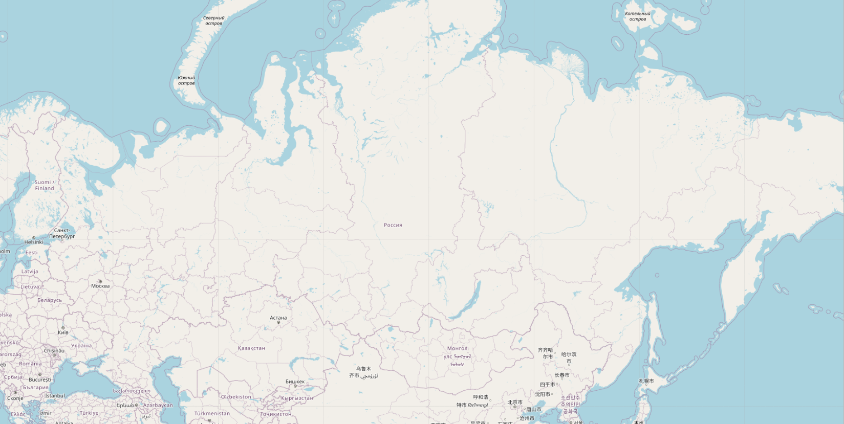
Продолжаем тему генерализации. Как известно, генерализация – это отбор и обобщение той информации, которую мы хотим показать на карте, особенно мелких (обзорных) масштабов.
В OSM c генерализацией все 20 лет всё совсем печально. Напоминаю, мапник на 4-м зуме пустой абсолютно.
Но мы же не будем сидеть сложа руки? Всего несколько строчек кода, и вуаля, на карте появились города:
 Посмотреть картинку в нормальном разрешении можно тут.
Видно не только Екатеринбург и Пермь, а вылезла даже Дудинка, Туруханск и Ленск.
Ни у кого такого нет, даже у гугла, а у меня есть. Вот интересно, мне поставят золотые памятники при жизни?
UPD. Вот в комментах пишут, что всё у всех есть, существует даже плагин для QGIS, который умеет вычислять “картографическую значимость” горных вершин и населенных пунктов. Это только на openstreetmap.org генерализации нет, потому что это не интересно osm-cообществу.
La idea partió desde la busqueda y visualización de Sector III en OpenStreetMap. Al darme cuenta de la práctica inexistencia de edificios y calles además de datos erróneos me creó una “obligación” de arreglar y añadir todo aquello que faltaba en el mapa. No iba a ser fácil pero estaba seguro de que iba a merecer la pena…
En este proyecto, vayamos más allá de lo obvio… La idea “mappear” todo “mappeable”. No pasé por alto cosas aparentemente pequeñas, como papeleras, bancos, farolas y otros “detalles urbanos”. Si bien pueden parecer insignificantes individualmente, hacen que la información sea realmente poderosa, especialmente para aplicaciones basadas en API.
El primero paso fue definir y dividir las áreas en las que se iba a trabajar. Dado que el Sector III de Getafe es bastante amplio, habría que dividir el proyecto en varias partes, en concreto en 41 zonas. Cada zona se iba a realizar de manera detallada y uniforme.
Estas fueran las zonas: * Public Areas [X8]
Urb. Arroyo Culebro (C. Islas Canarias) [X4]
Urb. Las Ladeas (Av. Europa) [X4]
Cooperativa Getafe 2001 [X4]
Urb. Nuevo Hogar [X4]
Buenavista (M. Azaña + 14 Abril + 2da. República) [X3]
Urb. Ruiz Alarnes [X2]
Urb. General Palacios [X2]
Urb. Las Artes [X1]
Urb. Cerro Buenavista [X1]
Urb. Bañolas II [X1]
Colonia Nuestra Señora de Loreto [X1]
Urb. Agora Este [X1]
Urb. Ivima [X1]
Urb. El Artesón [X1]
Urb. Pablo Iglesias [X1]
Urb. Cerro de la Herradura [X1]
Urb. Bañolas I [X1]
Una vez divididas las zonas, tocaba conocer el área. Tanto ayuda local, como diferente fuentes de información (autonómica y nacional) iban a ser clave para hacer un mapa completo y añadir tanta información como sea posible.
Заметку оставляю больше для себя. Если есть чем дополнить, пишите.
iD - редактор на официальном сайте OSM
الثوير
عقاير العلام
بير الدويمة


